Greenville, Georgia
| Greenville, Georgia | |
|---|---|
| City | |
|
The Greenville Historic District was added to the National Register of Historic Places on March 16, 1990. | |
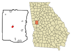 Location in Meriwether County and the state of Georgia | |
| Coordinates: 33°1′40″N 84°42′49″W / 33.02778°N 84.71361°WCoordinates: 33°1′40″N 84°42′49″W / 33.02778°N 84.71361°W | |
| Country | United States |
| State | Georgia |
| County | Meriwether |
| Area | |
| • Total | 1.8 sq mi (4.7 km2) |
| • Land | 1.8 sq mi (4.7 km2) |
| • Water | 0 sq mi (0 km2) |
| Elevation | 869 ft (265 m) |
| Population (2010) | |
| • Total | 876 |
| • Density | 525.6/sq mi (201.3/km2) |
| Time zone | Eastern (EST) (UTC-5) |
| • Summer (DST) | EDT (UTC-4) |
| ZIP code | 30222 |
| Area code(s) | 706 |
| FIPS code | 13-35016[1] |
| GNIS feature ID | 0356105[2] |
| Website | http://www.cityofgreenvillega.com |
Greenville is a city in Meriwether County, Georgia, United States. The population was 946 at the 2000 census. The city is the county seat of Meriwether County.[3] 54.9 miles (88.4 km) southwest of Atlanta. It is part of the Atlanta metropolitan area (Atlanta-Sandy Springs-Marietta, Georgia Metropolitan Statistical Area).
History
Greenville was founded in 1828 as seat of the newly formed Meriweather County.[4]
Geography
Greenville is located at 33°1′40″N 84°42′49″W / 33.02778°N 84.71361°W (33.027845, -84.713562).[5]
According to the United States Census Bureau, the city has a total area of 1.8 square miles (4.7 km2), of which, 1.8 square miles (4.7 km2) of it is land and 0.55% is water.
Demographics
| Historical population | |||
|---|---|---|---|
| Census | Pop. | %± | |
| 1880 | 490 | — | |
| 1900 | 815 | — | |
| 1910 | 909 | 11.5% | |
| 1920 | 760 | −16.4% | |
| 1930 | 672 | −11.6% | |
| 1940 | 683 | 1.6% | |
| 1950 | 733 | 7.3% | |
| 1960 | 726 | −1.0% | |
| 1970 | 1,085 | 49.4% | |
| 1980 | 1,213 | 11.8% | |
| 1990 | 1,167 | −3.8% | |
| 2000 | 946 | −18.9% | |
| 2010 | 876 | −7.4% | |
| Est. 2015 | 862 | [6] | −1.6% |
As of the census[1] of 2000, there were 946 people, 354 households, and 236 families residing in the city. The population density was 520.8 people per square mile (200.7/km²). There were 432 housing units at an average density of 237.8 per square mile (91.6/km²). The racial makeup of the city was 26.43% White, 73.15% African American, 0.11% Native American, 0.11% Pacific Islander, and 0.21% from two or more races. Hispanic or Latino of any race were 0.32% of the population.
There were 354 households out of which 29.4% had children under the age of 18 living with them, 34.5% were married couples living together, 29.4% had a female householder with no husband present, and 33.1% were non-families. 28.5% of all households were made up of individuals and 13.6% had someone living alone who was 65 years of age or older. The average household size was 2.67 and the average family size was 3.35.
In the city the population was spread out with 28.3% under the age of 18, 8.8% from 18 to 24, 28.2% from 25 to 44, 18.6% from 45 to 64, and 16.1% who were 65 years of age or older. The median age was 34 years. For every 100 females there were 84.4 males. For every 100 females age 18 and over, there were 73.8 males.
The median income for a household in the city was $25,114, and the median income for a family was $32,500. Males had a median income of $28,750 versus $21,346 for females. The per capita income for the city was $12,997. About 21.9% of families and 26.1% of the population were below the poverty line, including 34.2% of those under age 18 and 28.7% of those age 65 or over.
Education
Meriwether County School District
The Meriwether County School District holds pre-school to grade twelve, and consists of three elementary schools, two middle schools, and two high schools.[8] The district has 300 full-time teachers and over 3,948 students.[9]
- George E. Washington Elementary School
- Mountain View Elementary School
- Unity Elementary School
- Greenville Middle School
- Manchester Middle School
- Greenville High School
- Manchester High School
Notable people
- Kentavious Caldwell-Pope - 2013 SEC Player of the Year and 8th overall selection in the 2013 NBA draft by the Detroit Pistons.
- Joseph M. Terrell - former Governor of Georgia (1910-1911); from Greenville, buried in the local cemetery.
- Hiram Warner (1802-1881) - Hiram Warner was one of the original members of the Supreme Court of Georgia, eventually becoming that court's second chief justice. Warner also held office as a circuit court judge, a representative in the Georgia General Assembly, and a U.S. congressman.
- Mario Alford - wide receiver for the Cincinnati Bengals of the NFL.
Gallery
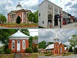
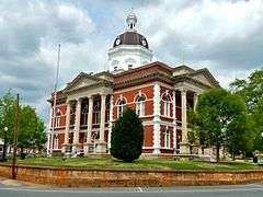 The Meriwether County Courthouse is located in Greenville, the county seat.
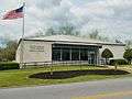 Greenville Post Office (ZIP code: 30222)
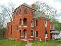 The Meriwether County Jail was built in 1896 and added to the National Register of Historic Places on May 7, 1973.
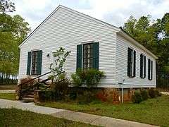 The Greenville Presbyterian Church and Cemetery was added to the National Register of Historic Places on February 5, 2002.
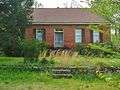 The Harman-Watson-Matthews House was added to the National Register of Historic Places on May 9, 1973.
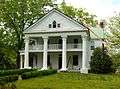 The Burwell O. Hill House was added to the National Register of Historic Places on June 17, 1982.
 The Hiram Warner Hill House was added to the National Register of Historic Places on April 7, 1983.
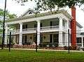 The Render Family Homestead was added to the National Register of Historic Places on March 1, 1984.
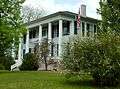 Twin Oaks, also known as Winsor Hall, was added to the National Register of Historic Places on August 26, 1980.
References
- 1 2 "American FactFinder". United States Census Bureau. Retrieved 2008-01-31.
- ↑ "US Board on Geographic Names". United States Geological Survey. 2007-10-25. Retrieved 2008-01-31.
- ↑ "Find a County". National Association of Counties. Retrieved 2011-06-07.
- ↑ Hellmann, Paul T. (May 13, 2013). Historical Gazetteer of the United States. Routledge. p. 232. Retrieved 30 November 2013.
- ↑ "US Gazetteer files: 2010, 2000, and 1990". United States Census Bureau. 2011-02-12. Retrieved 2011-04-23.
- ↑ "Annual Estimates of the Resident Population for Incorporated Places: April 1, 2010 to July 1, 2015". Retrieved July 2, 2016.
- ↑ "Census of Population and Housing". Census.gov. Retrieved June 4, 2015.
- ↑ Georgia Board of Education, Retrieved June 24, 2010.
- ↑ School Stats, Retrieved June 24, 2010.
Municipalities and communities of Meriwether County, Georgia, United States | ||
|---|---|---|
| Cities |  | |
| Towns | ||
| Unincorporated community | ||
| Footnotes | ‡This populated place also has portions in an adjacent county or counties | |