Greenville, Utah
| Greenville, Utah | |
|---|---|
| Unincorporated community | |
 Greenville Location within the state of Utah | |
| Coordinates: 38°15′16″N 112°42′45″W / 38.25444°N 112.71250°WCoordinates: 38°15′16″N 112°42′45″W / 38.25444°N 112.71250°W | |
| Country | United States |
| State | Utah |
| County | Beaver |
| Settled | 1861 |
| Founded by | Samuel Edwards |
| Named for | Green pastures |
| Elevation | 5,666 ft (1,727 m) |
| Time zone | Mountain (MST) (UTC-7) |
| • Summer (DST) | MDT (UTC-6) |
| ZIP codes | 84731 |
| Area code(s) | 435 |
| GNIS feature ID | 1428406[1] |
| Historical population | |||
|---|---|---|---|
| Census | Pop. | %± | |
| 1870 | 175 | — | |
| 1880 | 214 | 22.3% | |
| 1890 | 209 | −2.3% | |
| 1900 | 215 | 2.9% | |
| 1910 | 252 | 17.2% | |
| 1920 | 247 | −2.0% | |
| 1930 | 179 | −27.5% | |
| 1940 | 172 | −3.9% | |
| 1950 | 128 | −25.6% | |
| Source: U.S. Census Bureau[2] | |||
Greenville is an unincorporated community in eastern Beaver County, Utah, United States. It lies along State Route 21 southwest of the city of Beaver, the county seat of Beaver County.[3] Its elevation is 5,666 feet (1,727 m).[1] Although Greenville is unincorporated, it has a post office, with the ZIP code of 84731.[4]
Greenville was first settled in 1861.[5]
References
- 1 2 "Greenville, Utah". Geographic Names Information System. United States Geological Survey. Retrieved 2008-04-12.
- ↑ "Census of Population and Housing". U.S. Census Bureau. Retrieved November 4, 2011.
- ↑ Rand McNally. The Road Atlas '08. Chicago: Rand McNally, 2008, p. 102.
- ↑ Zip Code Lookup
- ↑ Andrew Jenson. Encyclopedic History of the Church. (Salt Lake City: Deseret Book, 1941) p. 304
Municipalities and communities of Beaver County, Utah, United States | ||
|---|---|---|
| Cities | 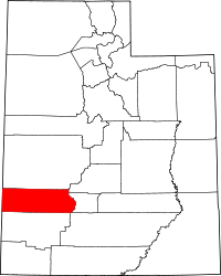 | |
| Town | ||
| Unincorporated communities | ||
| Ghost towns | ||
This article is issued from Wikipedia - version of the 8/23/2015. The text is available under the Creative Commons Attribution/Share Alike but additional terms may apply for the media files.