Groom, Texas
| Groom, Texas | |
|---|---|
| Town | |
 | |
 Location of Groom, Texas | |
 | |
| Coordinates: 35°12′11″N 101°6′24″W / 35.20306°N 101.10667°WCoordinates: 35°12′11″N 101°6′24″W / 35.20306°N 101.10667°W | |
| Country |
|
| State |
|
| County | Carson |
| Government | |
| • Type | Council-Manager |
| • City Council |
Mayor Joe Homer Chris Welch Kenneth Weller Matt Fields Buck Babcock Joe Rae Richardson |
| • City Secretary | Mary Sue Lyles |
| Area | |
| • Total | 0.75 sq mi (1.93 km2) |
| • Land | 0.75 sq mi (1.93 km2) |
| • Water | 0.0 sq mi (0.0 km2) |
| Elevation | 3,255 ft (992 m) |
| Population (2010) | |
| • Total | 574 |
| • Density | 771/sq mi (297.8/km2) |
| Time zone | Central (CST) (UTC-6) |
| • Summer (DST) | CDT (UTC-5) |
| ZIP code | 79039 |
| Area code(s) | 806 |
| FIPS code | 48-31292[1] |
| GNIS feature ID | 1358463[2] |
Groom is a town in Carson County, Texas, United States. The population was 574 at the 2010 census.[3] It is part of the Amarillo, Texas Metropolitan Statistical Area. It is on Interstate Highway 40 (Historic Route 66) 42 miles (68 km) east of Amarillo and 215 miles (346 km) west of Oklahoma City.
Geography
Groom is located in the southeastern corner of Carson County at 35°12′11″N 101°6′24″W / 35.20306°N 101.10667°W (35.203112, -101.106710).[4] Interstate 40 bypasses the town to the north, with access from Exits 110 through 114. Historic Route 66 (Business Route 40) passes through the center of town.
According to the United States Census Bureau, the town has a total area of 0.75 square miles (1.93 km2), all of it land.[3]
Demographics
| Historical population | |||
|---|---|---|---|
| Census | Pop. | %± | |
| 1930 | 564 | — | |
| 1940 | 475 | −15.8% | |
| 1950 | 678 | 42.7% | |
| 1960 | 679 | 0.1% | |
| 1970 | 808 | 19.0% | |
| 1980 | 736 | −8.9% | |
| 1990 | 613 | −16.7% | |
| 2000 | 587 | −4.2% | |
| 2010 | 574 | −2.2% | |
| Est. 2015 | 558 | [5] | −2.8% |
As of the census[1] of 2000, there were 587 people, 240 households, and 178 families residing in the town. The population density was 778.7 people per square mile (302.2/km²). There were 290 housing units at an average density of 384.7 per square mile (149.3/km²). The racial makeup of the town was 94.72% White, 0.17% Native American, 0.17% Asian, 2.90% from other races, and 2.04% from two or more races. Hispanic or Latino of any race were 4.77% of the population.
There were 240 households out of which 31.3% had children under the age of 18 living with them, 63.3% were married couples living together, 7.5% had a female householder with no husband present, and 25.8% were non-families. 25.8% of all households were made up of individuals and 16.3% had someone living alone who was 65 years of age or older. The average household size was 2.45 and the average family size was 2.92.
In the town the population was spread out with 26.6% under the age of 18, 6.8% from 18 to 24, 23.9% from 25 to 44, 22.0% from 45 to 64, and 20.8% who were 65 years of age or older. The median age was 40 years. For every 100 females there were 95.0 males. For every 100 females age 18 and over, there were 93.3 males.
The median income for a household in the town was $31,705, and the median income for a family was $39,063. Males had a median income of $30,577 versus $24,500 for females. The per capita income for the town was $15,593. About 9.4% of families and 13.2% of the population were below the poverty line, including 22.0% of those under age 18 and 11.8% of those age 65 or over.
Landmarks
Giant cross

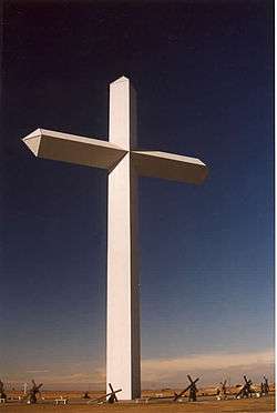
There is a 19-story cross located next to Interstate 40 just northwest of the town limits. This 190-foot-tall (58 m) free-standing cross can be seen from 20 miles (32 km) away. Surrounding the base of the cross are life-sized statues of the 14 Stations of the Cross. Inspired by this cross, residents of Effingham, Illinois, erected a similar cross that is 8 feet (2.4 m) taller. Many claim this cross to be the largest in the Western Hemisphere. However, it is smaller than the cross erected in the Valle de los Caídos in Spain, located at 40°38′29″N 04°09′26″W / 40.64139°N 4.15722°W and elevated 500 feet (152.4 m) overground. The cross is also 18 feet (5.5 m) shorter than the 208 ft (63 m) cross at the Mission Nombre de Dios in St. Augustine, Florida, and shorter than the 213-foot-tall (65 m) Lakeuden Risti cross-shaped church tower in Seinäjoki, Finland. The movie Leap of Faith was filmed on location near the site of the cross in Groom, but the movie was filmed before the cross was built.
Leaning water tower
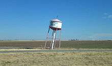
Also in Groom one can find a leaning water tower which currently serves as a decorative item. It originally was a functioning water tower which was slated for demolition until Ralph Britten bought it and moved it to serve as a sign for his truck stop and tourist information center (located on a stretch of interstate that was once a part of U.S. Route 66). This truck stop can still be seen, set back off the road behind the tower, now boarded up and in disrepair following a devastating fire decades ago.[7]
The leaning water tower still remains a popular target for cameras, and the town of Groom turns on a large colored star mounted on the top around Christmas time.[8] The water tower is a common image from Route 66 photography books.
Education
The Town of Groom is served by the Groom Independent School District and is home to the Groom High School Tigers.
History
Early exploration
The route from Fort Smith, Arkansas, to Santa Fe, New Mexico, along the Canadian River was charted circa 1849 by Captain Randolph Barnes Marcy. Published in 1859, Marcy's book, The Prairie Traveler: A Handbook for Overland Expeditions, contained maps and illustrations of routes between the Mississippi and the Pacific and was used as a basic manual by westward-bound wagon trains and travelers for years.[9]
Colonel B. B. Groom
Colonel B. B. Groom, an experienced cattleman near Lexington, Kentucky, leased from the New York and Texas Land Company 592,920 acres (2,399.5 km2) of land in Hutchinson, Carson, Gray, and Roberts counties in the Texas Panhandle in 1882, resulting in the organization of the Francklyn Land and Cattle Company. Groom purchased an estimated 1,300 head of shorthorns in 1882 and selected the Diamond F brand, approved by the Francklyn officials and filed as the company's brand in October 1882. Unfortunately, Groom's vision of the finest and most desirable cattle ranch in the United States did not materialize for him. The Francklyn Land and Cattle Company became insolvent in 1886. The bondholders foreclosed and organized a new company known as White Deer Lands (later White Deer Land Company), under the management of the agent Timothy Dwight Hobart, one of the subsequent founders of Pampa, Texas.[9][10]
Harrison Groom
Colonel Groom's son, Harrison Groom, established a camp at the edge of a little lake just west of the present town of White Deer.[9]
The town
The site of Groom was chosen in 1902, along the route of the Chicago, Rock Island and Gulf Railway. Groom was first incorporated in 1911.[11]
References in media
Cross Canadian Ragweed's song "42 Miles", off their album Highway 377, tells the story of the band's breaking down in Groom, Texas, and interacting with Keith Barkley at Keith's Auto in Groom.
Notable people
- Steve Haskins, professional golfer.
References
- 1 2 "American FactFinder". United States Census Bureau. Retrieved 2008-01-31.
- ↑ "US Board on Geographic Names". United States Geological Survey. 2007-10-25. Retrieved 2008-01-31.
- 1 2 "Geographic Identifiers: 2010 Census Summary File 1 (G001): Groom town, Texas". U.S. Census Bureau, American Factfinder. Retrieved July 23, 2015.
- ↑ "US Gazetteer files: 2010, 2000, and 1990". United States Census Bureau. 2011-02-12. Retrieved 2011-04-23.
- ↑ "Annual Estimates of the Resident Population for Incorporated Places: April 1, 2010 to July 1, 2015". Retrieved July 2, 2016.
- ↑ "Census of Population and Housing". Census.gov. Retrieved June 4, 2015.
- ↑ Wesley Treat; Heather Shades; Rob Riggs; Mark Moran; Mark Sceurman (2009-05-05). Weird Texas: Your Travel Guide to Texas's Local Legends and Best Kept Secrets. p. 170. ISBN 9781402766879. Retrieved 2012-05-29. ("Weird Texas". Retrieved 2012-05-29.)
- ↑ "Groom TX - Tower Fuel Stop. RT66-1107". Illinois Digital Archives.
- 1 2 3 The Log House on White Deer Creek, Eloise Lane Retrieved 2009-06-22
- ↑ "Francklyn Land and Cattle Company". The Handbook of Texas Online. Retrieved February 14, 2015.
- ↑ The Handbook of Texas Online Retrieved 2009-06-22
Municipalities and communities of Carson County, Texas, United States | ||
|---|---|---|
| Towns |  | |
| Unincorporated community | ||