Grundkallen
 Grundkallen Lighthouse | |
 Sweden | |
| Location |
20 km (12 mi) northeast of Öregrund Sweden |
|---|---|
| Coordinates | 60°29′43″N 18°50′59″E / 60.49528°N 18.84972°ECoordinates: 60°29′43″N 18°50′59″E / 60.49528°N 18.84972°E |
| Year first constructed | 1961 |
| Foundation | concrete |
| Construction | concrete tower |
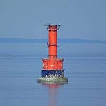
| Tower shape | cylindrical tower with double balcony and lantern on a 2-storey crew quarters, helipad on the top |
| Markings / pattern | red tower, black basement |
| Height | 34 m (111.5 ft) |
| Focal height | 32 m (105.0 ft) |
| Characteristic | LFl (3) WRG 20s. |
| Admiralty number | C6285 |
| NGA number | 10028 |
| ARLHS number | SWE-024 |
| Sweden number | SV-2187 |
| Managing agent | Swedish Maritime Administration (Sjöfartsverket)[1] |
Grundkallen is a Swedish lighthouse on a shallow of the same name in the southern part of the Gulf of Bothnia, some 20 kilometres (12 miles) northeast of Öregrund. The current 34-metre (111.5 ft) lighthouse was built in 1961 to replace a lightship in the same location. It is a round concrete tower with a helipad on top and a round two-storey crew quarters in the bottom, both painted red, mounted on a round caisson which is painted black. The lighthouse, owned by the Swedish Maritime Administration, is automated and unmanned.[2]
The wreck of Herakles-Bulk
On 3 March 2004 at around 00:30 (UTC+02) a Finnish pusher-barge combination Herakles-Bulk sank near the Grundkallen lighthouse. The combination had left Oxelösund two days earlier and was heading north with the barge fully laden with coal. On 2 March she ran into a storm and the captain, not certain if the vessel could be safely turned around in such conditions to seek shelter closer to the coast, decided to evacuate half of the crew by helicopter. When the port engine began overheating and later the starboard engine lost all power, the combination was no longer able to keep the bow into the wind and began to drift uncontrollably in the storm. The remaining crew was soon evacuated and shortly afterwards Herakles-Bulk collided with the lighthouse, causing superficial damage, and foundered in the nearby shallows.[3]
The 159-metre barge broke in two and an approximately 95 metres long section settled in the bottom on an even keel only tens of metres from the lighthouse. Part of the side structure and a ramp protrude above the surface. Another section, approximately 60 metres long, is located about 300 metres south-southeast from the lighthouse, with the forecastle of the barge protruding in an oblique angle above the surface.[3][4] The wrecks do not pose a hazard to navigation.[5]
See also
References
- ↑ Grundkallen The Lighthouse Directory. University of North Carolina at Chapel Hill. Retrieved April 4, 2016
- ↑ Rowlett, Russ. "Lighthouses of Sweden: Southern Bothnia". The Lighthouse Directory. University of North Carolina at Chapel Hill. Retrieved 13 April 2011.
- 1 2 Työntöproomuyhdistelmä HERAKLES-BULK, vaaratilanne ja uppoaminen Selkämerellä 2.–3.3.2004. Onnettomuustutkintakeskuksen tutkintaselostus B 02/2004 M.
- ↑ Swedish Maritime Administration: Notices to Mariners, SWEDEN, Nr 87 (2005-10-12). Retrieved 2010-07-12.
- ↑ Tornator 2/04.