Hampden Township, Coffey County, Kansas
| Hampden Township | |
|---|---|
| Township | |
 Location in Coffey County | |
| Coordinates: 38°11′35″N 095°42′06″W / 38.19306°N 95.70167°WCoordinates: 38°11′35″N 095°42′06″W / 38.19306°N 95.70167°W | |
| Country | United States |
| State | Kansas |
| County | Coffey |
| Area | |
| • Total | 29.55 sq mi (76.54 km2) |
| • Land | 21.74 sq mi (56.31 km2) |
| • Water | 7.81 sq mi (20.23 km2) 26.43% |
| Elevation | 1,060 ft (323 m) |
| Population (2000) | |
| • Total | 114 |
| • Density | 5.2/sq mi (2/km2) |
| GNIS feature ID | 0477463 |
Hampden Township is a township in Coffey County, Kansas, United States. As of the 2000 census, its population was 114.
Geography
Hampden Township covers an area of 29.55 square miles (76.5 km2) and contains no incorporated settlements. According to the USGS, it contains two cemeteries: Sherwood and Stringtown.
Mathias Lake is within this township. The stream of Wolf Creek runs through this township.
Wolf Creek Generating Station, a 1250MW nuclear power plant, operates here.
Transportation
Hampden Township contains one airport or landing strip, Wolf Creek Airport.
References
External links
Municipalities and communities of Coffey County, Kansas, United States | ||
|---|---|---|
| Cities | 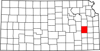 | |
| Unincorporated communities |
| |
| Townships | ||
This article is issued from Wikipedia - version of the 9/29/2015. The text is available under the Creative Commons Attribution/Share Alike but additional terms may apply for the media files.