Hanover, New Mexico
| Hanover, New Mexico | |
|---|---|
| Census-designated place | |
 Hanover, New Mexico | |
| Coordinates: 32°48′48″N 108°05′28″W / 32.81333°N 108.09111°WCoordinates: 32°48′48″N 108°05′28″W / 32.81333°N 108.09111°W | |
| Country | United States |
| State | New Mexico |
| County | Grant |
| Area[1] | |
| • Total | 1.397 sq mi (3.62 km2) |
| • Land | 1.397 sq mi (3.62 km2) |
| • Water | 0 sq mi (0 km2) |
| Elevation | 6,368 ft (1,941 m) |
| Population (2010)[2] | |
| • Total | 167 |
| • Density | 120/sq mi (46/km2) |
| Time zone | Mountain (MST) (UTC-7) |
| • Summer (DST) | MDT (UTC-6) |
| ZIP code | 88041 |
| Area code(s) | 575 |
| GNIS feature ID | 906824[3] |
Hanover is a census-designated place in Grant County, New Mexico, United States. Its population was 167 as of the 2010 census. Hanover has a post office with ZIP code 88041.[4][5] New Mexico State Road 152 and New Mexico State Road 356 pass through the community.
References
- ↑ "US Gazetteer files: 2010, 2000, and 1990". United States Census Bureau. 2011-02-12. Retrieved 2011-04-23.
- ↑ "American FactFinder". United States Census Bureau. Retrieved 2011-05-14.
- ↑ "Hanover". Geographic Names Information System. United States Geological Survey.
- ↑ United States Postal Service (2012). "USPS - Look Up a ZIP Code". Retrieved 2012-02-15.
- ↑ "Postmaster Finder - Post Offices by ZIP Code". United States Postal Service. Retrieved August 7, 2013.
Municipalities and communities of Grant County, New Mexico, United States | ||
|---|---|---|
| City | 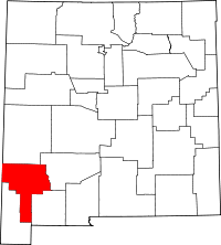 | |
| Towns | ||
| Village | ||
| CDPs | ||
| Other unincorporated communities | ||
| Ghost towns | ||
This article is issued from Wikipedia - version of the 7/29/2014. The text is available under the Creative Commons Attribution/Share Alike but additional terms may apply for the media files.