Harrison Township, Chautauqua County, Kansas
| Harrison Township | |
|---|---|
| Township | |
 Location in Chautauqua County | |
| Coordinates: 37°03′00″N 096°27′05″W / 37.05000°N 96.45139°WCoordinates: 37°03′00″N 096°27′05″W / 37.05000°N 96.45139°W | |
| Country | United States |
| State | Kansas |
| County | Chautauqua |
| Area | |
| • Total | 55.07 sq mi (142.64 km2) |
| • Land | 55 sq mi (142.44 km2) |
| • Water | 0.07 sq mi (0.19 km2) 0.13% |
| Elevation | 886 ft (270 m) |
| Population (2000) | |
| • Total | 114 |
| • Density | 2.1/sq mi (0.8/km2) |
| GNIS feature ID | 0469108 |
Harrison Township is a township in Chautauqua County, Kansas, USA. As of the 2000 census, its population was 114.
Geography
Harrison Township covers an area of 55.07 square miles (142.6 km2) and contains no incorporated settlements. According to the USGS, it contains two cemeteries: Osro Falls and Rose Dale.
The streams of Cedar Creek, Dry Creek, Possum Trot Creek, Rock Creek and Spring Branch run through this township.
References
External links
Municipalities and communities of Chautauqua County, Kansas, United States | ||
|---|---|---|
| Cities | 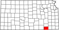 | |
| Unincorporated communities | ||
| Townships | ||
This article is issued from Wikipedia - version of the 11/11/2013. The text is available under the Creative Commons Attribution/Share Alike but additional terms may apply for the media files.