Harrodsburg, Kentucky
| Harrodsburg, Kentucky | |
|---|---|
| City | |
|
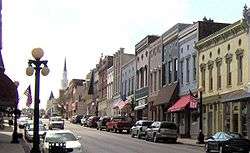
Downtown Harrodsburg, 2007 | |
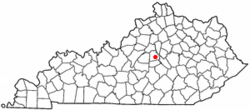 Location of Harrodsburg, Kentucky | |
| Coordinates: 37°45′50″N 84°50′46″W / 37.76389°N 84.84611°WCoordinates: 37°45′50″N 84°50′46″W / 37.76389°N 84.84611°W | |
| Country | United States |
| State | Kentucky |
| County | Mercer |
| Founded | June 16, 1774 |
| Incorporated | March 1, 1836 |
| Named for | James Harrod |
| Government | |
| • Mayor | Eddie Long |
| Area | |
| • Total | 5.3 sq mi (14 km2) |
| • Land | 5.3 sq mi (14 km2) |
| • Water | 0.0 sq mi (0 km2) |
| Elevation | 850 ft (260 m) |
| Population (2010) | |
| • Total | 8,340 |
| • Density | 1,573.6/sq mi (607.6/km2) |
| Time zone | Eastern (EST) (UTC-5) |
| • Summer (DST) | EDT (UTC-4) |
| ZIP code | 40330 |
| Area code(s) | 859 |
| FIPS code | 21-34966 |
| GNIS feature ID | 0493831 |
| Website | harrodsburgcity.org |
Harrodsburg is a home rule-class city[1] in Mercer County, Kentucky, in the United States. It is the seat of its county.[2] The population was 8,340 at the 2010 census.
Although Harrodsburg was formally established by the House of Burgesses after Boonesborough and was not incorporated by the Kentucky legislature until 1836,[3] it is usually considered the oldest city in Kentucky and has been honored as the oldest permanent American settlement west of the Appalachians.
History
Harrodstown (sometimes Harrod's Town) was laid out and founded by its namesake James Harrod on June 16, 1774.[4] Amid Dunmore's War, the settlement was abandoned later the same year as a result of Native American attacks, but it was resettled a year later in 1775. Fear of attacks from the Native Americans during the American Revolutionary War left it one of only three settlements in Kentucky after 1777, along with Logan's Fort and Boonesborough. Also known as Oldtown, Harrodstown was the first seat of Virginia's Kentucky (1776), Lincoln (1780), and Mercer (1785) counties upon their formations.[5] It remains the seat of Mercer County in Kentucky.
The settlement was formally established by the Virginia legislature in 1785 as Harrodsburg.[4] In 1789, it was named the location of the Kentucky Federal District Court.[6] The Kentucky legislature incorporated Harrodsburg in 1836.[3]
During the Civil War, the town was pro-Confederate[5] but Union control permitted the organization of the 19th Regiment Kentucky Volunteer Infantry at nearby Camp Harwood for a three-year enlistment commencing January 2, 1862, under the command of Col. William J. Landram. Following the Battle of Perryville, much of the city was converted into makeshift hospitals; 1600 sick and wounded Confederate soldiers were captured during a raid by the 9th Kentucky Cavalry under Lt Col. John Boyle on October 10, 1862. The city then remained under martial law for the remainder of the war.[5]
The Louisville Southern Railroad (LS) network reached the city in 1888. Louisville Southern Railway's construction commenced in 1884 and ran from Louisville through Shelbyville and Lawrenceburg to Harrodsburg, which was reached in 1888. A spur was constructed to Burgin, where the Louisville Southern joined the Cincinnati Southern's Cincinnati, New Orleans and Texas Pacific Railway CNO&TP mainline. Now all run and operated by Norfolk Southern Railway.
Pioneer Memorial Park (now Old Fort Harrod State Park) was opened on June 16, 1927. In 1936, Pres. Franklin Delano Roosevelt honored the city with a monument honoring the 'first permanent settlement west of the Appalachians'.[5]
Company D of the 192nd Tank Battalion in the Battle of Bataan was from Harrodsburg.[7]
Home to Shaker Village. http://shakervillageky.org
Geography
Harrodsburg is located at 37°45′50″N 84°50′46″W / 37.76389°N 84.84611°W (37.764019, -84.845974).[8] According to the United States Census Bureau, the city has a total area of 5.3 sq mi (13.7 km2), all land.
Transportation
U.S. 127 runs North-South through Harrodsburg. U.S. 127 Bypass goes around Harrodsburg. U.S. 68 runs East-West through Harrodsburg, but U.S. 68 turns onto U.S. 127 some of the time in Harrodsburg. SR 152 also runs East-West through Harrodsburg.
These are the following routes that runs through Harrodsburg.
Climate
Harrodsburg is in the humid subtropical climate zone, although verging on a humid continental climate.[9] Summers are hot and humid, and winters are cool with mild periods.
Average high is 87 °F in July and August, the warmest months, with the average lows of 26 °F in January, the coolest month. The highest recorded temperature was 105 °F in September 1954. The lowest recorded temperature was -18 °F in January 1985. Average annual precipitation is 45.73 inches (1,162 mm), with the wettest month being May, averaging 4.68 inches (119 mm).[10]
| Climate data for Harrodsburg, Kentucky | |||||||||||||
|---|---|---|---|---|---|---|---|---|---|---|---|---|---|
| Month | Jan | Feb | Mar | Apr | May | Jun | Jul | Aug | Sep | Oct | Nov | Dec | Year |
| Average high °F | 43 | 49 | 58 | 68 | 76 | 84 | 87 | 87 | 81 | 70 | 58 | 47 | 67 |
| Average low °F | 26 | 29 | 36 | 45 | 54 | 63 | 67 | 65 | 59 | 47 | 39 | 30 | 47 |
| Average precipitation inches | 3.36 | 3.52 | 4.28 | 3.81 | 4.68 | 4.29 | 4.56 | 3.85 | 3.09 | 2.95 | 3.45 | 3.89 | 45.73 |
| Average high °C | 6 | 9 | 14 | 20 | 24 | 29 | 31 | 31 | 27 | 21 | 14 | 8 | 19 |
| Average low °C | −3 | −2 | 2 | 7 | 12 | 17 | 19 | 18 | 15 | 8 | 4 | −1 | 8 |
| Average precipitation mm | 85.3 | 89.4 | 108.7 | 96.8 | 118.9 | 109 | 115.8 | 97.8 | 78.5 | 74.9 | 87.6 | 98.8 | 1,161.5 |
| Source: The Weather Channel [11] | |||||||||||||
Demographics
| Historical population | |||
|---|---|---|---|
| Census | Pop. | %± | |
| 1800 | 122 | — | |
| 1810 | 313 | 156.6% | |
| 1830 | 1,051 | — | |
| 1840 | 1,254 | 19.3% | |
| 1850 | 1,481 | 18.1% | |
| 1860 | 1,668 | 12.6% | |
| 1870 | 2,205 | 32.2% | |
| 1880 | 2,202 | −0.1% | |
| 1890 | 3,230 | 46.7% | |
| 1900 | 2,876 | −11.0% | |
| 1910 | 3,147 | 9.4% | |
| 1920 | 3,765 | 19.6% | |
| 1930 | 4,029 | 7.0% | |
| 1940 | 4,673 | 16.0% | |
| 1950 | 5,262 | 12.6% | |
| 1960 | 6,061 | 15.2% | |
| 1970 | 6,741 | 11.2% | |
| 1980 | 7,265 | 7.8% | |
| 1990 | 7,335 | 1.0% | |
| 2000 | 8,014 | 9.3% | |
| 2010 | 8,340 | 4.1% | |
| Est. 2015 | 8,394 | [12] | 0.6% |
As of the census[14] of 2000, there were 8,014 people, 3,449 households, and 2,234 families residing in the city. The population density was 1,510.5/sq mi (583.2/km2). There were 3,709 housing units at an average density of 699.1/sq mi (269.9/km2). The racial makeup of the city was 88.92% White, 7.52% African American, 0.14% Native American, 0.76% Asian, 0.02% Pacific Islander, 1.14% from other races, and 1.50% from two or more races. Hispanics or Latinos of any race were 2.15% of the population.
There were 3,449 households out of which 31.3% had children under the age of 18 living with them, 45.4% were married couples living together, 15.3% had a female householder with no husband present, and 35.2% were non-families. 32.1% of all households were made up of individuals and 16.6% had someone living alone who was 65 years of age or older. The average household size was 2.32 and the average family size was 2.91.
The age distribution was 25.1% under the age of 18, 9.0% from 18 to 24, 28.2% from 25 to 44, 20.9% from 45 to 64, and 16.8% who were 65 years of age or older. The median age was 36 years. For every 100 females there were 85.7 males. For every 100 females age 18 and over, there were 79.8 males.
The median income for a household in the city was US $27,500, and the median income for a family was $34,503. Males had a median income of $31,214 versus $21,216 for females. The per capita income for the city was $15,327. About 14.2% of families and 17.1% of the population were below the poverty line, including 21.1% of those under age 18 and 13.2% of those age 65 or over.
Education
Public education is provided by the Mercer County School District. The following list consists of the schools located within the district:[15]
- Harrodsburg Area Technology Center
- Mercer County Senior High School
- Kenneth D. King Middle School
- Mercer County Intermediate School
- Mercer County Elementary School
- Harlow Early Learning Center
Economy
- Hitachi Automotive Products is based in Harrodsburg
- Corning Incorporated has a plant located in Harrodsburg, which makes Gorilla Glass
Sister city
Notable people
- Ralph G. Anderson, founder Belcan Corporation, philanthropist
- Maria Thompson Daviess (1872-1924), author
- Jason Dunn, National Football League player
- David Winfield Huddleston, Christian author and minister
- Frances Wisebart Jacobs, philanthropist
- Dennis Johnson, National Football League player
- William Logan, politician
- Beriah Magoffin, Governor of Kentucky (1859 − 1862) and namesake of Magoffin County, Kentucky
- William Sullivan, politician and lawyer
- John Burton Thompson, politician
- Al Wilson, actor and stunt pilot
- Craig Yeast, National Football League player
See also
References
- ↑ "Summary and Reference Guide to House Bill 331 City Classification Reform" (PDF). Kentucky League of Cities. Retrieved December 30, 2014.
- ↑ "Find a County". National Association of Counties. Retrieved 2011-06-07.
- 1 2 Commonwealth of Kentucky. Office of the Secretary of State. Land Office. "Harrodsburg, Kentucky". Accessed 30 Jul 2013.
- 1 2 Rennick, Robert M. (1987). Kentucky Place Names. University Press of Kentucky. p. 132. Retrieved 28 Apr 2013.
- 1 2 3 4 Kleber, John E. (1992). The Kentucky Encyclopedia. Lexington KY: The University Press of Kentucky. ISBN 0-8131-1772-0.
- ↑ "Statutes at Large, 1st Congress, 1st Session". A Century of Lawmaking for a New Nation: U.S. Congressional Documents and Debates, 1774–1875. Library of Congress. Retrieved 2010-11-13.
- ↑ Life Magazine 1942
- ↑ "US Gazetteer files: 2010, 2000, and 1990". United States Census Bureau. 2011-02-12. Retrieved 2011-04-23.
- ↑ How Stuff Works Map of American climate zones. Retrieved on 2010-04-03
- ↑ Monthly Averages for Harrodsburg, Kentucky Retrieved on 2010-04-03
- ↑ "Monthly Averages for Harrodsburg KY". The Weather Channel.
- ↑ "Annual Estimates of the Resident Population for Incorporated Places: April 1, 2010 to July 1, 2015". Retrieved July 2, 2016.
- ↑ "Census of Population and Housing". Census.gov. Retrieved June 4, 2015.
- ↑ "American FactFinder". United States Census Bureau. Retrieved 2008-01-31.
- ↑ Mercer County School District Retrieved on 2010-05-04
External links
| Wikimedia Commons has media related to Harrodsburg, Kentucky. |
| Wikivoyage has a travel guide for Harrodsburg, Kentucky. |
- City of Harrodsburg
- Mercer County Chamber of Commerce
- Harrodsburg / Mercer County Tourist Commission
Municipalities and communities of Mercer County, Kentucky, United States | ||
|---|---|---|
| Cities |  | |
| CDP | ||
| Unincorporated communities | ||
| Ghost town | ||