Hastings, Michigan
| Hastings | |
|---|---|
| City | |
|
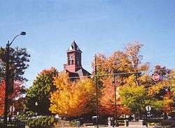
Barry County Courthouse in downtown Hastings | |
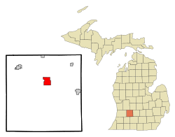 Location of Hastings, Michigan | |
| Coordinates: 42°38′50″N 85°17′13″W / 42.64722°N 85.28694°W | |
| Country | United States |
| State | Michigan |
| County | Barry |
| Area[1] | |
| • Total | 5.28 sq mi (13.68 km2) |
| • Land | 5.20 sq mi (13.47 km2) |
| • Water | 0.08 sq mi (0.21 km2) |
| Elevation | 807 ft (246 m) |
| Population (2010)[2] | |
| • Total | 7,350 |
| • Estimate (2012[3]) | 7,299 |
| • Density | 1,413.5/sq mi (545.8/km2) |
| Time zone | Eastern (EST) (UTC-5) |
| • Summer (DST) | EDT (UTC-4) |
| ZIP code | 49058 |
| Area code(s) | 269 |
| FIPS code | 26-37120[4] |
| GNIS feature ID | 1618841[5] |
Hastings is a city in the U.S. state of Michigan, the county seat of Barry County as well as the county's only city.[6] The population was 7,350 at the 2010 census. The city borders Hastings Charter Township on the north, east, and south, and Rutland Charter Township on the west.
Hastings is part of the Grand Rapids-Wyoming metropolitan area.
Major highways
History
In 1836 three entrepreneurs named Dibble, Kingsbury and Kendall bought 480 acres (1.9 km2) along the Thornapple River from Detroit banker Eurotas P. Hastings. The three platted the area into lots, and soon a small community arose. In 1843, the state legislature designated Hastings as the County Seat of Barry County. The first paper, the Barry County Pioneer, began publishing in 1851, and a second paper, the Republican Banner, began in 1856. The latter publication, a weekly paper published on Thursdays, continues to be published as the Hastings Banner.
Hastings was incorporated as a village in 1855, with a population of around 300, and on March 11, 1871, Hastings officially become a city. The Barry County Courthouse, which is still in use today, was built in 1893. The city grew slowly, reaching 6,500 people in 1960 and remaining nearly flat through 1990.
Demographics
| Historical population | |||
|---|---|---|---|
| Census | Pop. | %± | |
| 1870 | 1,793 | — | |
| 1880 | 2,531 | 41.2% | |
| 1890 | 2,972 | 17.4% | |
| 1900 | 3,172 | 6.7% | |
| 1910 | 4,383 | 38.2% | |
| 1920 | 5,132 | 17.1% | |
| 1930 | 5,227 | 1.9% | |
| 1940 | 5,175 | −1.0% | |
| 1950 | 6,096 | 17.8% | |
| 1960 | 6,375 | 4.6% | |
| 1970 | 6,501 | 2.0% | |
| 1980 | 6,418 | −1.3% | |
| 1990 | 6,549 | 2.0% | |
| 2000 | 7,095 | 8.3% | |
| 2010 | 7,350 | 3.6% | |
| Est. 2015 | 7,284 | [7] | −0.9% |
2010 census
As of the census[2] of 2010, there were 7,350 people, 2,910 households, and 1,849 families residing in the city. The population density was 1,413.5 inhabitants per square mile (545.8/km2). There were 3,231 housing units at an average density of 621.3 per square mile (239.9/km2). The racial makeup of the city was 96.9% White, 0.5% African American, 0.6% Native American, 0.3% Asian, 0.5% from other races, and 1.2% from two or more races. Hispanic or Latino of any race were 2.7% of the population.
There were 2,910 households of which 34.9% had children under the age of 18 living with them, 44.2% were married couples living together, 14.4% had a female householder with no husband present, 5.0% had a male householder with no wife present, and 36.5% were non-families. 31.0% of all households were made up of individuals and 14.9% had someone living alone who was 65 years of age or older. The average household size was 2.47 and the average family size was 3.07.
The median age in the city was 36.2 years. 26.6% of residents were under the age of 18; 9% were between the ages of 18 and 24; 24.7% were from 25 to 44; 24.1% were from 45 to 64; and 15.4% were 65 years of age or older. The gender makeup of the city was 46.9% male and 53.1% female.
2000 census
As of the census[4] of 2000, there were 7,095 people, 2,759 households, and 1,826 families residing in the city. The population density was 1,353.3 per square mile (522.8/km²). There were 2,898 housing units at an average density of 552.8/sq mi (213.5/km²). The racial makeup of the city was 97.31% White, 0.14% African American, 0.47% Native American, 0.32% Asian, 0.58% from other races, and 1.18% from two or more races. Hispanic or Latino of any race were 2.14% of the population.
There were 2,759 households out of which 35.9% had children under the age of 18 living with them, 49.9% were married couples living together, 12.5% had a female householder with no husband present, and 33.8% were non-families. 28.9% of all households were made up of individuals and 13.7% had someone living alone who was 65 years of age or older. The average household size was 2.50 and the average family size was 3.08.
In the city the population was spread out with 27.7% under the age of 18, 9.1% from 18 to 24, 29.2% from 25 to 44, 18.6% from 45 to 64, and 15.3% who were 65 years of age or older. The median age was 34 years. For every 100 females there were 88.2 males. For every 100 females age 18 and over, there were 83.1 males.
The median income for a household in the city was $39,033, and the median income for a family was $44,886. Males had a median income of $35,226 versus $24,727 for females. The per capita income for the city was $18,042. About 5.9% of families and 8.1% of the population were below the poverty line, including 8.3% of those under age 18 and 5.8% of those age 65 or over.
Geography
According to the United States Census Bureau, the city has a total area of 5.28 square miles (13.68 km2), of which 5.20 square miles (13.47 km2) is land and 0.08 square miles (0.21 km2) is water.[1] The Thornapple River passes through the city from east to west.
Climate
The Köppen Climate Classification subtype for this climate is "Dfb" (Warm Summer Continental Climate).[9]
| Climate data for Hastings, Michigan | |||||||||||||
|---|---|---|---|---|---|---|---|---|---|---|---|---|---|
| Month | Jan | Feb | Mar | Apr | May | Jun | Jul | Aug | Sep | Oct | Nov | Dec | Year |
| Average high °C (°F) | 31 (−1) |
33 (1) |
44 (7) |
59 (15) |
70 (21) |
80 (27) |
84 (29) |
82 (28) |
75 (24) |
63 (17) |
47 (8) |
35 (2) |
58.6 (14.8) |
| Average low °C (°F) | 15 (−9) |
15 (−9) |
24 (−4) |
35 (2) |
45 (7) |
55 (13) |
59 (15) |
57 (14) |
50 (10) |
39 (4) |
30 (−1) |
20 (−7) |
37 (2.9) |
| Average precipitation mm (inches) | 2.0 (51) |
1.7 (43) |
2.2 (56) |
3.0 (76) |
3.5 (89) |
3.7 (94) |
3.1 (79) |
3.2 (81) |
3.4 (86) |
2.8 (71) |
2.7 (69) |
2.2 (56) |
33.5 (851) |
| Source: Weatherbase [10] | |||||||||||||
Schools
Hastings School District
- Hastings High School (website) has been located at 520 West South Street since 1970, previously located at 232 West Grand Street.
- Hastings Middle School (website) is located at 232 West Grand Street.
- Central Elementary (website) is located at 509 South Broadway.
- Southeastern Elementary (website) is located at 1300 South East Street.
- Northeastern Elementary (website) is located 519 East Grant Street.
- Star Elementary (website) is located at 1900 Star School Road.
- Barry County Special Education (website)
Private Schools
- St. Rose Of Lima (website) is a Catholic elementary school offering grades K-6 as well as a licensed preschool program. It is located at 707 South Jefferson Street. It associated with the St Rose of Lima Parish (website) and named for Rose of Lima (1586–1617), the first Catholic saint of the Americas.
- Barry County Christian School (website) is located at 2999 McKeown Road.
Community College
Since 1996, Kellogg Community College (with its main campus in Battle Creek, Michigan) maintains a regional campus at the Fehsenfeld Center in Hastings. (website)
New public library
The new LEED Gold-certified Hastings Public Library opened on June 7, 2007.
Events
Since 2013, downtown Hastings has hosted the annual Barry-Roubaix: Killer Gravel Road Race,[11] a cycling event and community celebration that has grown to attract over 3000 participants.
Notable people
- Lady Baldwin, MLB baseball player in 1800s
- Dave Joppie, MLB player and coach
- John C. Ketcham, congressman
- Loyal Edwin Knappen, judge of United States District Court for the Western District of Michigan
- Charles Rufus Morey, art historian
- Fred Rehor, pre-NFL professional football player for the Massillon Tigers
- Bruce Rendon, politician
- Albert Leroy Rule, documentary film producer
References
- 1 2 "US Gazetteer files 2010". United States Census Bureau. Retrieved 2012-11-25.
- 1 2 "American FactFinder". United States Census Bureau. Retrieved 2012-11-25.
- ↑ "Population Estimates". United States Census Bureau. Retrieved 2013-06-03.
- 1 2 "American FactFinder". United States Census Bureau. Retrieved 2008-01-31.
- ↑ "US Board on Geographic Names". United States Geological Survey. 2007-10-25. Retrieved 2008-01-31.
- ↑ "Find a County". National Association of Counties. Retrieved 2011-06-07.
- ↑ "Annual Estimates of the Resident Population for Incorporated Places: April 1, 2010 to July 1, 2015". Retrieved July 2, 2016.
- ↑ "Census of Population and Housing". Census.gov. Retrieved June 4, 2015.
- ↑ "Hastings, Michigan Köppen Climate Classification (Weatherbase)". Weatherbase.
- ↑ "Weatherbase.com". Weatherbase. 2013. Retrieved on June 28, 2013.
- ↑ ., Molly (21 Mar 2013). "BARRY ROUBAIX: 62 MILES OF DIRT, GRAVEL AND SNOW". Cyclocross Magazine. Hastings, MI. Retrieved 4 Jan 2015.
External links
Municipalities and communities of Barry County, Michigan, United States | ||
|---|---|---|
| City | 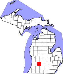 | |
| Villages | ||
| Charter townships | ||
| Civil townships | ||
| Unincorporated communities | ||
Coordinates: 42°38′45″N 85°17′27″W / 42.64583°N 85.29083°W