Hasuda, Saitama
| Hasuda 蓮田市 | |||
|---|---|---|---|
| City | |||
|
Hasuda City Hall | |||
| |||
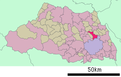 Location of Hasuda in Saitama Prefecture | |||
 Hasuda Location of Hasuda in Saitama Prefecture | |||
| Coordinates: 35°59′40.2″N 139°39′44.6″E / 35.994500°N 139.662389°ECoordinates: 35°59′40.2″N 139°39′44.6″E / 35.994500°N 139.662389°E | |||
| Country | Japan | ||
| Region | Kantō | ||
| Prefecture | Saitama Prefecture | ||
| Area | |||
| • Total | 27.28 km2 (10.53 sq mi) | ||
| Population (February 2016) | |||
| • Total | 62,284 | ||
| • Density | 2,280/km2 (5,900/sq mi) | ||
| Time zone | Japan Standard Time (UTC+9) | ||
| - Tree | flowering dogwood | ||
| - Flower | Nymphaea | ||
| Phone number | 048-768-3111 | ||
| Address | 2799-1 Kurohama, Hasuda-shi, Saitama-ken 349-0193 | ||
| Website | Official website | ||


Hasuda (蓮田市 Hasuda-shi) is a city located in Saitama Prefecture, in the central Kantō region of Japan. As of 1 February 2016, the city had an estimated population of 62,284 and a population density of 2280 persons per km². Its total area was 27.28 square kilometres (10.53 sq mi).
Geography
Located in eastern Saitama Prefecture, Hasuda is directly north of the prefectural capital of Saitama City.
Surrounding municipalities
History
The area of modern Hasuda has been settled since the prehistoric period, and there are numerous archaeological sites, including shell middens and burial mounds within the city limits. In addition, traces of samurai residences and castles from the Sengoku period remain. Much of what is now Hasuda was part of Iwatsuki Domain under the Edo period Tokugawa shogunate. After the Meiji restoration, the village of Ayase was created within Minamisaitama District with the establishment of the municipalities system on April 1, 1889. It was raised to town status on October 1, 1934 and renamed Hasuda. Hasuda annexed the neighboring villages of Kurohama and Hirano on May 3, 1954 and was elevated to city status on October 1, 1972.
On March 31, 2010, Hasuda was to be merged with the neighboring town of Shiraoka (from Minamisaitama District).[1] However, the merger was canceled shortly after Shiraoka managed to grow its population to 50,000 people, qualifying it as a city.
Economy
Due to this location, Hasuda is primarily a bedroom community with over half of its population commuting to neighboring Saitama City or to the Tokyo metropolis for work. However, much of the city remains agricultural.
Education
- Kindergarten
- Oyama kindergarten
- Kurohama kindergarten
- Shirayuri kindergarten
- Shinjuku kindergarten
- Hasuda Kindergarten
- Nursery
- Nakamura home nursery room
- Hasuda Municipal Kaizuka nursery
- Hasuda Municipal Kurohama Nursery
- Hasuda Municipal Chuo nursery
- Hasuda Municipal Hasuda South nursery
- Hasuda Municipal East nursery
- Hasuda Municipal Uruido nursery
- Elementary school
- Hasuda Municipal Kurohama Kita Elementary school
- Hasuda Municipal Kurohama Elementary School
- Hasuda Municipal Kurohama Nishi Elementary School
- Hasuda Municipal Kurohama Minami Elementary School
- Hasuda Municipal Hasuda North Elementary School
- Hasuda Municipal Hasuda Central Primary School
- Hasuda Municipal Hasuda Minami Elementary School
- Hasuda Municipal Plain Elementary School
- Middle Schools
- Hasuda Municipal Kurohama Middle School
- Hasuda Municipal Kurohama Nishi Middle School
- Hasuda Municipal Hasuda Middle School
- Hasuda Municipal Hasuda south Middle School
- Hasuda Municipal Hirano Middle School
- High Schools
- Saitama Hasuda Shoin High School
- Vocational school
- National Hospital Organization Higashisaitamabyoin University School of Nursing
- Special Education School
- Saitama Prefectural Hasuda Special Education School
Transportation
Railway
Highway
Local attractions
- Kurohama Shell Midden, a Jomon period National Historic Monument
References
External links
| Wikimedia Commons has media related to Hasuda, Saitama. |
- Official website (Japanese)
| Wards of Saitama | ||
|---|---|---|
| Core cities | ||
| Special cities | ||
| Cities | ||
| Chichibu District | ||
| Hiki District | ||
| Iruma District | ||
| Kitaadachi District | ||
| Kitakatsushika District | ||
| Kodama District | ||
| Minamisaitama District | ||
| Ōsato District | ||