Hatherton, Staffordshire
| Hatherton | |
|---|---|
|
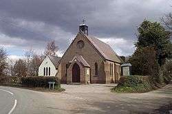
St. Saviour, Hatherton | |
| Coordinates: 52°41′27″N 2°03′41″W / 52.6908°N 2.0615°WCoordinates: 52°41′27″N 2°03′41″W / 52.6908°N 2.0615°W | |
| Country | England |
| County | Staffordshire |
Hatherton is a settlement and civil parish located 3 1⁄4 miles (5.2 km) south-east of Penkridge, and on the western edge of modern-day Cannock, Staffordshire, England,[1] and lying adjacent to and north of Watling Street, now the A5.[2]
The civil parish include the village of Calf Heath.[3]
Hatherton was given to Wolverhampton monastery by Lady Wulfruna in 994.[2] Its name, Hagerthorndun in the Domesday Book, means "the hill where Hawthorns grow".[2] It was once an exclave of Wolverhampton.
Hatherton gave its name to the title of Baron Hatherton, and thus to the now-derelict, nearby, Hatherton Canal.[4]
The Four Crosses inn at Hatherton features an inscription dated '1636N'.[2] Hatherton Hall is an 1817, late-Georgian house, stucco finished, replacing a former Norman hall.[2] The village church, St Saviour, dates from 1876.[2]
References
- ↑ "History of Hatherton in South Staffordshire - Map and description". Retrieved 27 October 2012.
- 1 2 3 4 5 6 Raven, Michael (2005). A Guide to Staffordshire and the Black Country, the Potteries and the Peak. Ashley, Market Drayton. pp. 168–169. ISBN 0906114330.
- ↑ South Staffordhire council
- ↑ Hadfield, Charles (1985). The Canals of the West Midlands. David and Charles. ISBN 0-7153-8644-1.
External links
 Media related to Hatherton, Staffordshire at Wikimedia Commons
- Hatherton in the Domesday Book
| Unitary authorities | |
|---|---|
| Boroughs or districts | |
| Major settlements | |
| Rivers | |
| Canals | |
| Topics | |