Hawthorne, New Jersey
| Hawthorne, New Jersey | |
|---|---|
| Borough | |
| Borough of Hawthorne | |
|
| |
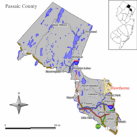 Map of Hawthorne in Passaic County. Inset: Location of Passaic County highlighted in the State of New Jersey. | |
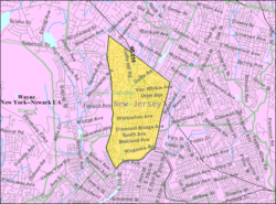 Census Bureau map of Hawthorne, New Jersey | |
| Coordinates: 40°57′25″N 74°09′31″W / 40.956957°N 74.158561°WCoordinates: 40°57′25″N 74°09′31″W / 40.956957°N 74.158561°W[1][2] | |
| Country |
|
| State |
|
| County | Passaic |
| Incorporated | March 24, 1898 |
| Named for | Nathaniel Hawthorne |
| Government[3] | |
| • Type | Faulkner Act (Mayor-Council) |
| • Body | Borough Council |
| • Mayor | Richard S. Goldberg (R, term ends December 31, 2017)[4][5] |
| • Administrator | Eric Maurer[6] |
| • Clerk | Lori DiBella[7] |
| Area[1] | |
| • Total | 3.364 sq mi (8.715 km2) |
| • Land | 3.334 sq mi (8.636 km2) |
| • Water | 0.030 sq mi (0.079 km2) 0.90% |
| Area rank |
318th of 566 in state 10th of 16 in county[1] |
| Elevation[8] | 85 ft (26 m) |
| Population (2010 Census)[9][10][11] | |
| • Total | 18,791 |
| • Estimate (2015)[12] | 19,074 |
| • Rank |
136th of 566 in state 6th of 16 in county[13] |
| • Density | 5,635.3/sq mi (2,175.8/km2) |
| • Density rank |
93rd of 566 in state 6th of 16 in county[13] |
| Time zone | Eastern (EST) (UTC-5) |
| • Summer (DST) | Eastern (EDT) (UTC-4) |
| ZIP codes | 07506-07507[14] |
| Area code(s) | 973[15] |
| FIPS code | 3403130570[1][16][17] |
| GNIS feature ID | 0885249[1][18] |
| Website |
www |
Hawthorne (pronounced HAW-thorn) is a borough in Passaic County, New Jersey, United States. As of the 2010 United States Census, the borough's population was 18,791[9][10][11] reflecting an increase of 573 (+3.1%) from the 18,218 counted in the 2000 Census, which had in turn increased by 1,134 (+6.6%) from the 17,084 counted in the 1990 Census.[19]
Hawthorne was originally part of the now-defunct Manchester Township, which was later subdivided to create Hawthorne, Haledon, North Haledon, Prospect Park, Totowa and most of the First Ward of Paterson. The Borough of Hawthorne was incorporated from portions of Manchester Township by an act of the New Jersey Legislature on March 24, 1898.[20] The borough was named for novelist Nathaniel Hawthorne.[21][22]
Geography
According to the United States Census Bureau, the borough had a total area of 3.364 square miles (8.715 km2), including 3.334 square miles (8.636 km2) of land and 0.030 square miles (0.079 km2) of water (0.90%).[1][2]
Unincorporated communities, localities and place names located partially or completely within the borough include Goffle, North Hawthorne and Van Winkle.[23]
The borough borders North Haledon, Prospect Park, and Paterson in Passaic County; and Fair Lawn, Glen Rock, Ridgewood and Wyckoff in Bergen County.[24]
Demographics
| Historical population | |||
|---|---|---|---|
| Census | Pop. | %± | |
| 1900 | 2,096 | — | |
| 1910 | 3,400 | 62.2% | |
| 1920 | 5,135 | 51.0% | |
| 1930 | 11,868 | 131.1% | |
| 1940 | 12,610 | 6.3% | |
| 1950 | 14,816 | 17.5% | |
| 1960 | 17,735 | 19.7% | |
| 1970 | 19,173 | 8.1% | |
| 1980 | 18,200 | −5.1% | |
| 1990 | 17,084 | −6.1% | |
| 2000 | 18,218 | 6.6% | |
| 2010 | 18,791 | 3.1% | |
| Est. 2015 | 19,074 | [12][25] | 1.5% |
| Population sources: 1900-1920[26] 1900-1910[27] 1900-1930[28] 1930-1990[29] 2000[30][31] 2010[9][10][11] | |||
2010 Census
At the 2010 United States Census, there were 18,791 people, 7,454 households, and 4,949 families residing in the borough. The population density was 5,635.3 per square mile (2,175.8/km2). There were 7,756 housing units at an average density of 2,326.0 per square mile (898.1/km2). The racial makeup of the borough was 88.62% (16,652) White, 2.27% (426) Black or African American, 0.21% (40) Native American, 2.82% (530) Asian, 0.00% (0) Pacific Islander, 4.28% (804) from other races, and 1.80% (339) from two or more races. Hispanics or Latinos of any race were 15.42% (2,897) of the population.[9]
There were 7,454 households, of which 29.5% had children under the age of 18 living with them, 50.7% were married couples living together, 11.4% had a female householder with no husband present, and 33.6% were non-families. 27.6% of all households were made up of individuals, and 11.1% had someone living alone who was 65 years of age or older. The average household size was 2.52 and the average family size was 3.12.[9]
In the borough, 21.4% of the population were under the age of 18, 7.3% from 18 to 24, 28.6% from 25 to 44, 28.3% from 45 to 64, and 14.4% who were 65 years of age or older. The median age was 40.2 years. For every 100 females there were 92.7 males. For every 100 females age 18 and over, there were 89.4 males.[9]
The Census Bureau's 2006-2010 American Community Survey showed that (in 2010 inflation-adjusted dollars) median household income was $72,985 (with a margin of error of +/- $6,585) and the median family income was $83,136 (+/- $7,364). Males had a median income of $64,906 (+/- $7,150) versus $44,641 (+/- $2,852) for females. The per capita income for the borough was $33,872 (+/- $1,921). About 4.9% of families and 7.1% of the population were below the poverty line, including 11.4% of those under age 18 and 7.2% of those age 65 or over.[32]
Same-sex couples headed 48 households in 2010, a 50% increase from the 32 counted in 2000.[33]
2000 Census
As of the 2000 United States Census[16] there were 18,218 people, 7,260 households, and 4,929 families residing in the borough. The population density was 5,364.9 people per square mile (2,068.8/km2). There were 7,419 housing units at an average density of 2,184.8 per square mile (842.5/km2). The racial makeup of the borough was 93.75% White, 0.75% African American, 0.14% Native American, 1.89% Asian, 0.02% Pacific Islander, 1.58% from other races, and 1.88% from two or more races. Hispanic or Latino of any race were 7.43% of the population.[30][31]
There were 7,260 households out of which 28.8% had children under the age of 18 living with them, 54.1% were married couples living together, 10.3% had a female householder with no husband present, and 32.1% were non-families. 26.5% of all households were made up of individuals and 11.1% had someone living alone who was 65 years of age or older. The average household size was 2.50 and the average family size was 3.07.[30][31]
In the borough the population was spread out with 21.8% under the age of 18, 6.5% from 18 to 24, 33.5% from 25 to 44, 22.7% from 45 to 64, and 15.5% who were 65 years of age or older. The median age was 38 years. For every 100 females there were 91.1 males. For every 100 females age 18 and over, there were 87.7 males.[30][31]
The median income for a household in the borough was $55,340, and the median income for a family was $65,451. Males had a median income of $46,270 versus $33,277 for females. The per capita income for the borough was $26,551. About 2.6% of families and 3.4% of the population were below the poverty line, including 4.0% of those under age 18 and 5.4% of those age 65 or over.[30][31]
Government
Local government
The Borough of Hawthorne is governed under the Faulkner Act, formally known as the Optional Municipal Charter Law, within the Mayor-Council system of municipal government by a Mayor and a seven-member Borough Council.[3][34]
A Charter Study Commission, formed in the 1980s after two major commercial businesses left the borough, led to a recommendation for the adoption of a Mayor-Council form in which there are four wards to give residents a representative in each area of the community, in addition to a mayor and two at-large members of the borough council, all of whom are directly elected by residents, with all members of the governing body serving four-year terms of office. After residents approved the commission's recommendations, the first election under the Mayor-Council form was held in 1989. The four ward seats are up for vote together and the three at-large seats and the mayoral position up for vote together two years later. All elections are held on a partisan basis as part of the November general election.[35]
As of 2016, the Mayor of the Borough of Hawthorne is Republican Richard S. Goldberg, whose term of office ends December 31, 2017.[4] Members of the Hawthorne Borough Council are Council President John Bertollo (Ward 2, 2019), Council Vice President Frank E. Matthews (Ward 4, 2019), Bruce Bennett (R, at large, 2017), John V. Lane (R, at large, 2017), Dominic Mele (R, at large, 2017), Gary G. Sinning (Ward 3, 2019) and Joseph R. Wojtecki (Ward 1, 2019).[36][37][38][39][40]
On July 29, 2008, former Mayor Patrick Botbyl announced he would resign effective August 15, 2008.[41] A special election was held on November 4, 2008, in which Richard Goldberg defeated Joseph Wojtecki to become the mayor of Hawthorne for the remainder of Botbyl's term.[42]
Emergency services
The Hawthorne Police Department is staffed with one Chief, three Captains, four Lieutenants, five Sergeants, 17 Patrol Officers, and three Detectives. The Police Headquarters is located at 445 Lafayette Avenue.[43]
The Hawthorne Volunteer Fire Department, established in 1916, is an all-volunteer department, which maintains five stations. HFD staffs three Engines (Engine 1, Engine 3, Engine 4), one Platform Aerial (Tower 2), and a Heavy Rescue (Rescue 5). HFD has one Department Chief and five Assistant Chiefs. The Fire Department Headquarters is located at 828 Lafayette Avenue.[44]
The Hawthorne Volunteer Ambulance Corps is an independent non-profit corporation dedicated to providing emergency medical services (EMS) to the Borough of Hawthorne and surrounding communities since 1932. HVAC maintains three full-size BLS units, one First Responder/Command Vehicle, and one chief's vehicle. The EMS Headquarters is located at 970 Goffle Road.[45]
Federal, state and county representation
Hawthorne is located in the 9th Congressional District[46] and is part of New Jersey's 38th state legislative district.[10][47][48] Prior to the 2011 reapportionment following the 2010 Census, Hawthorne had been in the 35th state legislative district.[49]
New Jersey's Ninth Congressional District is represented by Bill Pascrell (D, Paterson).[50] New Jersey is represented in the United States Senate by Cory Booker (D, Newark, term ends 2021)[51] and Bob Menendez (D, Paramus, 2019).[52][53]
For the 2016–2017 session (Senate, General Assembly), the 38th Legislative District of the New Jersey Legislature is represented in the State Senate by Robert M. Gordon (D, Fair Lawn) and in the General Assembly by Tim Eustace (D, Maywood) and Joseph Lagana (D, Paramus).[54] The Governor of New Jersey is Chris Christie (R, Mendham Township).[55] The Lieutenant Governor of New Jersey is Kim Guadagno (R, Monmouth Beach).[56]
Passaic County is governed by a seven-member Board of Chosen Freeholders, who are elected at-large to staggered three-year terms office on a partisan basis, with two or three seats coming up for election each year as part of the November general election in a three-year cycle. At a reorganization meeting held in January, the board selects a Director and Deputy Director from among its members to serve for a one-year term.[57] As of 2015, Passaic County's Freeholders are Freeholder Director Hector C. Lora (D, term ends December 31, 2015; Passaic),[58] Freeholder Deputy Director Bruce James (D, 2017; Clifton),[59] John W. Bartlett (D, 2015; Wayne),[60] Theodore O. Best, Jr. (D, 2017; Paterson),[61] Ronda Cotroneo (D, 2015; Ringwood),[62] Terry Duffy (D, 2016; West Milford),[63] and Pat Lepore (D, 2016; Woodland Park).[64][65][66] Constitutional officers elected on a countywide basis are County Clerk Kristin M. Corrado (R, 2019),[67] Sheriff Richard H. Berdnik (2016)[68] and Surrogate Bernice Toledo (2016).[69][70][71]
Politics
As of March 23, 2011, there were a total of 12,060 registered voters in Hawthorne, of which 2,938 (24.4% vs. 31.0% countywide) were registered as Democrats, 3,934 (32.6% vs. 18.7%) were registered as Republicans and 5,181 (43.0% vs. 50.3%) were registered as Unaffiliated. There were 7 voters registered to other parties.[72] Among the borough's 2010 Census population, 64.2% (vs. 53.2% in Passaic County) were registered to vote, including 81.7% of those ages 18 and over (vs. 70.8% countywide).[72][73]
In the 2012 presidential election, Democrat Barack Obama received 49.9% of the vote (4,195 cast), ahead of Republican Mitt Romney with 48.9% (4,114 votes), and other candidates with 1.2% (101 votes), among the 8,480 ballots cast by the borough's 12,679 registered voters (70 ballots were spoiled), for a turnout of 66.9%.[74][75] In the 2008 presidential election, Republican John McCain received 4,618 votes (50.6% vs. 37.7% countywide), ahead of Democrat Barack Obama with 4,256 votes (46.6% vs. 58.8%) and other candidates with 78 votes (0.9% vs. 0.8%), among the 9,132 ballots cast by the borough's 12,101 registered voters, for a turnout of 75.5% (vs. 70.4% in Passaic County).[76] In the 2004 presidential election, Republican George W. Bush received 4,614 votes (52.7% vs. 42.7% countywide), ahead of Democrat John Kerry with 3,863 votes (44.1% vs. 53.9%) and other candidates with 52 votes (0.6% vs. 0.7%), among the 8,753 ballots cast by the borough's 11,624 registered voters, for a turnout of 75.3% (vs. 69.3% in the whole county).[77]
In the 2013 gubernatorial election, Republican Chris Christie received 62.0% of the vote (3,385 cast), ahead of Democrat Barbara Buono with 36.9% (2,015 votes), and other candidates with 1.2% (63 votes), among the 5,586 ballots cast by the borough's 12,874 registered voters (123 ballots were spoiled), for a turnout of 43.4%.[78][79] In the 2009 gubernatorial election, Republican Chris Christie received 3,139 votes (53.7% vs. 43.2% countywide), ahead of Democrat Jon Corzine with 2,324 votes (39.8% vs. 50.8%), Independent Chris Daggett with 265 votes (4.5% vs. 3.8%) and other candidates with 36 votes (0.6% vs. 0.9%), among the 5,844 ballots cast by the borough's 11,836 registered voters, yielding a 49.4% turnout (vs. 42.7% in the county).[80]
Education
The Hawthorne Public Schools serve public school students in Kindergarten through twelfth grade. As of the 2011-12 school year, the district's five schools had an enrollment of 2,168 students and 173.0 classroom teachers (on an FTE basis), for a student–teacher ratio of 12.53:1.[81] Schools in the district (with 2011-12 enrollment data from the National Center for Education Statistics[82]) are three K-5 elementary schools — Jefferson Elementary School[83] (266 students), Roosevelt Elementary School[84] (541) and Washington Elementary School[85] (286) — Lincoln Middle School[86] (567) serves students from the 6th through 8th grades and Hawthorne High School[87] (663) serves students from grades 9 through 12.[88]
In addition to public schools, the K-8 Catholic school, St. Anthony's, operates under the supervision of the Roman Catholic Diocese of Paterson.[89] Hawthorne Christian Academy is an evangelical Christian school established in 1981 by the Hawthorne Gospel Church, serving students in preschool through twelfth grade.[90]
Transportation
Roads and highways
As of May 2010, the borough had a total of 61.77 miles (99.41 km) of roadways, of which 47.63 miles (76.65 km) were maintained by the municipality, 12.45 miles (20.04 km) by Passaic County and 1.69 miles (2.72 km) by the New Jersey Department of Transportation.[91]
Public transportation
New Jersey Transit provides train service at the Hawthorne station[92] providing service on the Main Line to Secaucus Junction and Hoboken Terminal.[93]
New Jersey Transit provides bus service on the 148 route to the Port Authority Bus Terminal in Midtown Manhattan, with local service on the 722 route.[94][95]
Community
Hawthorne is home to the Hawthorne Caballeros Drum and Bugle Corps, which was founded in 1946 and competes as an all-age corps in Drum Corps Associates. The Caballeros are headquartered at Hawthorne's American Legion Post 199.
Bedrin/WalMart Market controversy
A controversy has erupted since the Council voted to allow 24/7 hours of operation in order to accommodate the development of a WalMart Market at 204 Wagaraw Road.[96] Although the planning board approved a supermarket with 42,000 square feet (3,900 m2) of floor space, the identity of the occupant, WalMart Inc., and the hours of operation, 24/7, were not made clear in the public notification. Beginning in January 2012, a group of concerned citizens began asking questions of the developer, County Planning Board, Hawthorne Planning Board and the Hawthorne Borough Council. Residents have raised concerns about the possibility for increased crime that a 24/7 operation could bring given a parking lot large enough for 250+ automobiles and increased drug use at the 24/7 7-Eleven in Hawthorne. Other concerns include increased traffic to an already congested area, decease in public safety, decrease in property values, increased noise and air pollution, and an overall negative association of WalMart being associated with Hawthorne.[97]
In May 2014, the Borough Council passed an ordinance that would prohbit big box retailers from opening in the borough's main retail districts; Wal-Mart had announced in March 2013 that it would abandon its efforts to open in Hawthorne.[98][99]
Notable people
People who were born in, residents of, or otherwise closely associated with Hawthorne include:
- Fulvio Cecere (born 1960), actor.[100]
- Maurice Carthon (born 1961), former running back for the New York Giants.[101]
- Lois A. Cuccinello, former member of the Passaic County Board of Chosen Freeholders who became the first woman to serve as Freeholder Director in four decades.[102]
- Beth Fowler (born 1940), actress.[103]
- Maria Mazziotti Gillan (born 1940), poet, professor and editor; winner of an American Book Award (2008).[104]
- John Girgenti (born 1947), New Jersey State Senator from the 35th Legislative District.[105]
- Debbie Harry (born 1945), rock and roll musician who originally gained fame as the frontwoman for the new wave band Blondie.[106][107]
- William Cahoone Johnson, Jr., died helping passengers on to lifeboats on the RMS Titanic [108]
- Dale Memmelaar (born 1937), offensive lineman in the NFL from 1959 through 1967.[109]
- Roberta Naas (born 1958), journalist.
- Ivan Sergei (born 1972), television actor.[110][111]
References
- 1 2 3 4 5 6 2010 Census Gazetteer Files: New Jersey County Subdivisions, United States Census Bureau. Accessed May 21, 2015.
- 1 2 US Gazetteer files: 2010, 2000, and 1990, United States Census Bureau. Accessed September 4, 2014.
- 1 2 2012 New Jersey Legislative District Data Book, Rutgers University Edward J. Bloustein School of Planning and Public Policy, March 2013, p. 151.
- 1 2 Mayor Richard S. Goldberg, Borough of Hawthorne. Accessed July 28, 2016.
- ↑ 2016 New Jersey Mayors Directory, New Jersey Department of Community Affairs. Accessed June 14, 2016.
- ↑ Administration, Borough of Hawthorne. Accessed July 28, 2016.
- ↑ Borough Clerk, Borough of Hawthorne. Accessed July 28, 2016.
- ↑ U.S. Geological Survey Geographic Names Information System: Borough of Hawthorne, Geographic Names Information System. Accessed March 5, 2013.
- 1 2 3 4 5 6 DP-1 - Profile of General Population and Housing Characteristics: 2010 for Hawthorne borough, Passaic County, New Jersey, United States Census Bureau. Accessed August 14, 2012.
- 1 2 3 4 Municipalities Grouped by 2011-2020 Legislative Districts, New Jersey Department of State, p. 15. Accessed January 6, 2013.
- 1 2 3 Profile of General Demographic Characteristics: 2010 for Hawthorne borough, New Jersey Department of Labor and Workforce Development. Accessed August 14, 2012.
- 1 2 PEPANNRES - Annual Estimates of the Resident Population: April 1, 2010 to July 1, 2015 - 2015 Population Estimates for New Jersey municipalities, United States Census Bureau. Accessed May 22, 2016.
- 1 2 GCT-PH1 Population, Housing Units, Area, and Density: 2010 - State -- County Subdivision from the 2010 Census Summary File 1 for New Jersey, United States Census Bureau. Accessed July 31, 2013.
- ↑ Look Up a ZIP Code for Hawthorne, NJ, United States Postal Service. Accessed August 14, 2012.
- ↑ Area Code Lookup - NPA NXX for Hawthorne, NJ, Area-Codes.com. Accessed January 26, 2015.
- 1 2 American FactFinder, United States Census Bureau. Accessed September 4, 2014.
- ↑ A Cure for the Common Codes: New Jersey, Missouri Census Data Center. Accessed August 15, 2012.
- ↑ US Board on Geographic Names, United States Geological Survey. Accessed September 4, 2014.
- ↑ Table 7. Population for the Counties and Municipalities in New Jersey: 1990, 2000 and 2010, New Jersey Department of Labor and Workforce Development, February 2011. Accessed August 14, 2012.
- ↑ Snyder, John P. The Story of New Jersey's Civil Boundaries: 1606-1968, Bureau of Geology and Topography; Trenton, New Jersey; 1969. p. 209. Accessed August 16, 2012.
- ↑ Hutchinson, Viola L. The Origin of New Jersey Place Names, New Jersey Public Library Commission, May 1945. Accessed August 31, 2015.
- ↑ Gannett, Henry. The Origin of Certain Place Names in the United States, p. 138. United States Government Printing Office, 1905. Accessed August 31, 2015.
- ↑ Locality Search, State of New Jersey. Accessed May 21, 2015.
- ↑ Areas touching Hawthorne, MapIt. Accessed August 14, 2015.
- ↑ Census Estimates for New Jersey April 1, 2010 to July 1, 2015, United States Census Bureau. Accessed May 22, 2016.
- ↑ Compendium of censuses 1726-1905: together with the tabulated returns of 1905, New Jersey Department of State, 1906. Accessed July 31, 2013.
- ↑ Thirteenth Census of the United States, 1910: Population by Counties and Minor Civil Divisions, 1910, 1900, 1890, United States Census Bureau, p. 338. Accessed August 15, 2012.
- ↑ Fifteenth Census of the United States : 1930 - Population Volume I, United States Census Bureau, p. 711. Accessed December 19, 2011.
- ↑ Table 6. New Jersey Resident Population by Municipality: 1930 - 1990, New Jersey Department of Labor and Workforce Development. Accessed June 28, 2015.
- 1 2 3 4 5 Census 2000 Profiles of Demographic / Social / Economic / Housing Characteristics for Hawthorne borough, New Jersey, United States Census Bureau. Accessed August 14, 2012.
- 1 2 3 4 5 DP-1: Profile of General Demographic Characteristics: 2000 - Census 2000 Summary File 1 (SF 1) 100-Percent Data for Hawthorne borough, Passaic County, New Jersey, United States Census Bureau. Accessed August 14, 2012.
- ↑ DP03: Selected Economic Characteristics from the 2006-2010 American Community Survey 5-Year Estimates for Hawthorne borough, Passaic County, New Jersey, United States Census Bureau. Accessed August 15, 2012.
- ↑ Lipman, Harvy; and Sheingold, Dave. "North Jersey sees 30% growth in same-sex couples", The Record (Bergen County), August 14, 2011, backed up by the Internet Archive as of February 3, 2013. Accessed December 1, 2014.
- ↑ Form of Government, Borough of Hawthorne. Accessed August 15, 2012.
- ↑ History, Borough of Hawthorne. Accessed December 19, 2011.
- ↑ Borough Council, Borough of Hawthorne. Accessed July 28, 2016.
- ↑ 2016 Municipal User Friendly Budget, Borough of Hawthorne. Accessed July 28, 2016.
- ↑ Passaic County 2016 Directory, Passaic County, New Jersey, March 2016. Accessed July 28, 2016. As of date accessed, the four ward members are listed incorrectly with 2018 term-end years.
- ↑ November 3, 2015 Summary Report Passaic County Official Results, Passaic County, New Jersey, updated November 12, 2015. Accessed July 28, 2016.
- ↑ November 5, 2013 Summary Report Passaic County, Passaic County, New Jersey, updated November 15, 2013. Accessed July 28, 2016.
- ↑ Welch, Christian. "Botbyl Plans to Resign", The Gazette, August 6, 2008, p.2.
- ↑ Kays, Heather. "Mystery Surrounds Mayor's Exit", The Herald News, August 5, 2008.
- ↑ Police Department, Borough of Hawthorne. Accessed July 28, 2016.
- ↑ Home Page, Hawthorne Volunteer Fire Department. Accessed July 28, 2016.
- ↑ About Us, Hawthorne Volunteer Ambulance Corps. Accessed July 28, 2016.
- ↑ Plan Components Report, New Jersey Redistricting Commission, December 23, 2011. Accessed January 6, 2013.
- ↑ 2016 New Jersey Citizen's Guide to Government, p. 58, New Jersey League of Women Voters. Accessed July 20, 2016.
- ↑ Districts by Number for 2011-2020, New Jersey Legislature. Accessed January 6, 2013.
- ↑ 2011 New Jersey Citizen's Guide to Government, p. 58, New Jersey League of Women Voters. Accessed May 22, 2015.
- ↑ Directory of Representatives: New Jersey, United States House of Representatives. Accessed January 5, 2012.
- ↑ About Cory Booker, United States Senate. Accessed January 26, 2015. "He now owns a home and lives in Newark's Central Ward community."
- ↑ Biography of Bob Menendez, United States Senate, January 26, 2015. "He currently lives in Paramus and has two children, Alicia and Robert."
- ↑ Senators of the 114th Congress from New Jersey. United States Senate. Accessed January 26, 2015. "Booker, Cory A. - (D - NJ) Class II; Menendez, Robert - (D - NJ) Class I"
- ↑ Legislative Roster 2016-2017 Session, New Jersey Legislature. Accessed January 17, 2016.
- ↑ "About the Governor". State of New Jersey. Retrieved 2010-01-21.
- ↑ "About the Lieutenant Governor". State of New Jersey. Retrieved 2010-01-21.
- ↑ Clerk-Freeholders, Passaic County, New Jersey. Accessed January 27, 2015.
- ↑ Hector C. Lora, Passaic County, New Jersey. Accessed January 27, 2015.
- ↑ Bruce James, Passaic County, New Jersey. Accessed January 27, 2015.
- ↑ John W. Bartlett, Passaic County, New Jersey. Accessed January 27, 2015.
- ↑ Theodore O. Best Jr., Passaic County, New Jersey. Accessed January 27, 2015.
- ↑ Ronda Cotroneo, Passaic County, New Jersey. Accessed January 27, 2015.
- ↑ Terry Duffy, Passaic County, New Jersey. Accessed January 27, 2015.
- ↑ Pat Lepore, Passaic County, New Jersey. Accessed January 27, 2015.
- ↑ Freeholders, Passaic County, New Jersey. Accessed January 27, 2015.
- ↑ 2014 County Data Sheet, Passaic County, New Jersey. Accessed January 27, 2015.
- ↑ County Clerk, Passaic County, New Jersey. Accessed January 27, 2015.
- ↑ Richard H. Berdnik, Passaic County Sheriff's Office. Accessed January 27, 2015.
- ↑ County Surrogate, Passaic County, New Jersey. Accessed January 27, 2015.
- ↑ Kleimann, James. "Passaic County general election results 2014", NJ Advance Media for NJ.com, November 4, 2014. Accessed January 27, 2015.
- ↑ 2014 Passaic County Directory, Passaic County, New Jersey. Accessed January 27, 2015.
- 1 2 Voter Registration Summary - Passaic, New Jersey Department of State Division of Elections, March 23, 2011. Accessed January 16, 2013.
- ↑ GCT-P7: Selected Age Groups: 2010 - State -- County Subdivision; 2010 Census Summary File 1 for New Jersey, United States Census Bureau. Accessed January 16, 2013.
- ↑ "Presidential General Election Results - November 6, 2012 - Passaic County" (PDF). New Jersey Department of Elections. March 15, 2013. Retrieved December 24, 2014.
- ↑ "Number of Registered Voters and Ballots Cast - November 6, 2012 - General Election Results - Passaic County" (PDF). New Jersey Department of Elections. March 15, 2013. Retrieved December 24, 2014.
- ↑ 2008 Presidential General Election Results: Passaic County, New Jersey Department of State Division of Elections, December 23, 2008. Accessed January 16, 2013.
- ↑ 2004 Presidential Election: Passaic County, New Jersey Department of State Division of Elections, December 13, 2004. Accessed January 16, 2013.
- ↑ "Governor - Passaic County" (PDF). New Jersey Department of Elections. January 29, 2014. Retrieved December 24, 2014.
- ↑ "Number of Registered Voters and Ballots Cast - November 5, 2013 - General Election Results - Passaic County" (PDF). New Jersey Department of Elections. January 29, 2014. Retrieved December 24, 2014.
- ↑ 2009 Governor: Passaic County, New Jersey Department of State Division of Elections, December 31, 2009. Accessed January 16, 2013.
- ↑ District information for Hawthorne School District, National Center for Education Statistics. Accessed January 26, 2015.
- ↑ School Data for the Hawthorne Public Schools, National Center for Education Statistics. Accessed January 13, 2013.
- ↑ Jefferson Elementary School, Hawthorne Public Schools. Accessed July 31, 2013.
- ↑ Roosevelt Elementary School, Hawthorne Public Schools. Accessed July 31, 2013.
- ↑ Washington Elementary School, Hawthorne Public Schools. Accessed July 31, 2013.
- ↑ Lincoln Middle School, Hawthorne Public Schools. Accessed July 31, 2013.
- ↑ Hawthorne High School, Hawthorne Public Schools. Accessed July 31, 2013.
- ↑ New Jersey School Directory for the Hawthorne Public Schools, New Jersey Department of Education. Accessed July 31, 2013.
- ↑ Passaic County Schools, Roman Catholic Diocese of Paterson. Accessed August 14, 2015.
- ↑ About HCA, Hawthorne Christian Academy. Accessed December 19, 2011.
- ↑ Passaic County Mileage by Municipality and Jurisdiction, New Jersey Department of Transportation, May 2010. Accessed July 18, 2014.
- ↑ Hawthorne station, New Jersey Transit. Accessed December 2, 2014.
- ↑ Main/Bergen-Port Jervis Line, New Jersey Transit. Accessed December 2, 2014.
- ↑ Passaic County Bus / Rail Connections, New Jersey Transit, backed up by the Internet Archive as of July 26, 2010. Accessed December 2, 2014.
- ↑ Passaic County System Map, New Jersey Transit. Accessed August 14, 2015.
- ↑ Cattafi, Kristie. "Objections to Walmart continue in Hawthorne", The Gazette, March 13, 2012. Accessed August 15, 2012.
- ↑ Cattafi, Kristie. "Residents express opposition to Walmart supermarket possibly coming to Hawthorne", The Gazette, February 16, 2012. Accessed August 15, 2012.
- ↑ Kleimann, James. "Wal-Mart, other big box stores kept out of Hawthorne", NJ Advance Media for NJ.com, May 9, 2014. Accessed August 31, 2015. "Wal-Mart and other big box stores won't be setting up shop in Hawthorne anytime soon, with the borough council passing an ordinance Wednesday night that prohibits big box development on two main commercial stretches, according to The Record."
- ↑ Park, Minjae. "Hawthorne shuns big-box developments like Walmart", The Record (Bergen County), May 7, 2014. Accessed August 31, 2015. "Wal-Mart announced in March 2013 it would scrap plans to bring a supermarket to Wagaraw Road after its application was met with fierce resistance from some residents, who argued the supermarket undercut community aspirations for a better development suitor. On Wednesday night, the council — which had argued Walmart would bring in much-needed tax ratables — unanimously adopted a zoning ordinance that forecloses the possibility of any big-box developments returning to a stretch of Wagaraw Road, including the 8.6-acre lot where Wal-Mart planned to locate."
- ↑ Koetting, Rebecca. "Local acts way to NYPD Blue fame", The Shopper News. Accessed January 13, 2013. "The part is being played by Fulvio Cecere, of the Hawthorne High School Class of 1978. Though Cecere currently resides in Canada, he still maintains close ties to the borough, where his parents call Diamond Bridge Avenue home."
- ↑ Sturken, Barbara. "Off the Field, Giants Call New Jersey Home", The New York Times, March 31, 1991. Accessed August 15, 2012. "Others hitting the books during the off-season include Maurice Carthon, fullback, who lives in Hawthorne."
- ↑ Biography of Freeholder Lois A. Cuccinello, Passaic County, New Jersey. Accessed December 20, 2006.
- ↑ Beckerman, Jim. "Fowler draws on salon ties for role", The Record (Bergen County), March 12, 2008. Accessed March 12, 2008. "Born in Jersey City, raised in Rutherford (she cut her acting teeth with the Bergen County Players in Oradell), she lived in Teaneck, Hawthorne and Glen Rock before settling, eight years ago, in New Milford."
- ↑ Page, Jeffrey. "MARIA MAZZIOTTI GILLAN, HAWTHORNE POET -- `PEOPLE LOVE THE POEMS THAT MOVE THEM'", The Record (Bergen County), December 20, 1998. Accessed January 26, 2015.
- ↑ Senator Girgenti's Legislative Website, New Jersey Legislature. Accessed July 16, 2007.
- ↑ Rohan, Virginia. "Hawthorne's Debbie Harry continues to record and wow audiences", The Record (Bergen County), June 18, 2007. "Harry, who grew up in Hawthorne, expected to perform about a half dozen of the new songs on this month's True Colors tour, which stops at Radio City tonight."
- ↑ Farber, Jim via Daily News (New York). "Blondie's back: Band keeps the spirit and sex of New York Pop-Punk aliv", The Beaver County Times, April 11, 2004. Accessed January 13, 2013. "The last ditty, 'Shakedown', lets Harry vent hen New Jersey pride (she grew up in Hawthorne) in colorfully rude ways."
- ↑ Levin, Jay. "Hawthorne seaman died helping to save the lives of others on the Titanic", The Record (Bergen County), April 15, 2012. Accessed April 15, 2012.
- ↑ Dale Memmelaar, Database Football. Accessed December 9, 2008.
- ↑ Bobbin, Jay. "Mailbag", Eugene Register-Guard, November 27, 1999. Accessed January 13, 2013. "Sergei is actually a native of Hawthorne, N.J."
- ↑ Rohan, Virginia. "North Jersey-bred and talented too", The Record (Bergen County), June 18, 2007. "Ivan Sergei: Class of 1989, Hawthorne High School"
External links
| Wikimedia Commons has media related to Hawthorne, New Jersey. |
- Hawthorne Borough website
- Hawthorne Public Schools
- Hawthorne Public Schools's 2014–15 School Report Card from the New Jersey Department of Education
- School Data for the Hawthorne Public Schools, National Center for Education Statistics
- Hawthorne High School Alumni Forum
- Hawthorne NYS&W train station restoration and preservation
Municipalities and communities of Passaic County, New Jersey, United States | ||
|---|---|---|
| Cities |  | |
| Boroughs | ||
| Townships | ||
| CDPs | ||
| Other unincorporated communities | ||