Heights of Guan
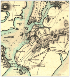
The Heights of Guan, a variant of "Gowanus", was the New York colonial era name given to a series of hills which extend in a ridge along the western portion of Long Island. The ridge extends in an east northeast direction starting from Bay Ridge, Brooklyn with hills of varying heights of 100 to 150 feet (30-45m), with the southern slope of the ridge having a relatively steep drop and the rear, a more gradual slope. The ridge marks the terminal moraine of the Wisconsin Glacier that formed the North Shore of Long Island, south of the ridge is the outwash plain bordered by the Atlantic Ocean.
During the American Revolution the hills played a strategic role during the Battle of Brooklyn. The ridge formed a natural defensive line against an attacking force from the south due to the steepness of the southern slope and the heavily wooded terrain covered in dense brush. There were only four passes through the Heights of Guan.[1]
- Gowanus Pass: Where 7,000 troops under General James Grant attacked 2,000 troops under Lord Stirling after the initial skirmish of the battle at the Red Lion Inn.
- Flatbush Pass (Battle Pass), where the Flatbush Road cut through the pass. The Americans had chopped down a large oak tree called the Dongan Oak to block the road and the pass at a location which is in today's Prospect Park.
- Bedford Pass: The troops defending this pass retreated toward the Battle Pass after being outflanked. Today the location of the pass is a small street known as Clove Road.
- Jamaica Pass: The lightly guarded pass on the Jamaica road that the British used to outflank the Americans after capturing the four American horseman on guard. Howe forced William Howard, owner of Howard's Tavern located on the Jamaica Road to the south of the Heights of Guan, and his fourteen-year-old son, to show him the way to an old Rockaway Indian trail, called the Rockaway Path, which skirted the pass itself. It is in today's Evergreen Cemetery.[2]
In the decades after the war, population growth was not as great here as in other nearby rural areas. Roads were improved, however, and with urban sprawl after the mid-19th century various railroads crossed the Heights including the South Brooklyn Railway. Prospect Reservoir and Ridgewood Reservoir were built on the Heights to serve the water needs of the growing City of Brooklyn, and Eastern Parkway later ran along the ridgeline between them. Park Slope and Crown Heights became prosperous suburban commuter towns.
External links
References
- ↑ Scheer, George F. Rebels and Redcoats: The American Revolution Through the Eyes of Those that Fought and Lived it. Hugh F. Rankin. Da Capo Press.
- ↑ Stiles, Henry Reed. A History of the City of Brooklyn. p. 267.