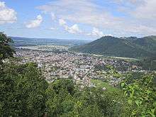
Hetauda
| Hetauda हेटौंडा | |
|---|---|
| Sub-Metropolitan City | |
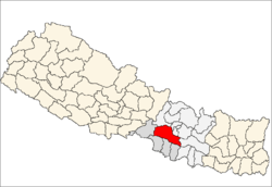
 Hetauda Location in Nepal | |
| Coordinates: 27°25′N 85°02′E / 27.417°N 85.033°ECoordinates: 27°25′N 85°02′E / 27.417°N 85.033°E | |
| Country |
|
| Zone | Narayani Zone |
| District | Makwanpur District |
| Government | |
| • Type | Sub-metropolitan city |
| Area | |
| • Total | 187.7 km2 (72.5 sq mi) |
| Elevation | 345 m (1,132 ft) |
| Population (2011) | |
| • Total | 84,671 |
| • Density | 450/km2 (1,200/sq mi) |
| Time zone | NST (UTC+5:45) |
| Post code | 44100, 44107 |
| Area code(s) | 057 |
| Website | www.hetaudamun.gov.np |
Hetauda (Nepali: हेटौडा) is a sub-metropolitan city in the Makwanpur District of the Narayani Zone of southern Nepal. It is the administrative headquarters of the Makwanpur District and the headquarters of Nepal's Central Development Region. The city has 84,671 inhabitants in 2011. At the time of the 1991 Nepal census, it had a population of 53,836 people living in 10,420 households.[1]
Hetauda is 132 km from Nepal's capital, Kathmandu, via the old Tribhuvan Highway. There are now two alternate roads that are less than 80 km, i.e. just 2-3 hrs drive from Kathmandu valley, but they have not been fully blacktopped. Construction works are being carried out. Also first tunneling road is being constructed which is believed to shorten the distance between Hetauda-Kathmandu. It is expected that traveling time from Kathmandu to Hetauda via tunnel road will be just 57 min and 13 sec only.
The city is surrounded by three rivers—the Rapti to the west, the Samari to the north, and the Karra to the south—and is part of an important industrial regions. The settlement developed because of its location along the Tribhuvan Highway, and was later linked to another major national thoroughfare: the Mahendra Highway, also known as the East-West Highway.
Geography
The city is situated in a unique geographical structure called Doon, which means that it has a geography like a valley.[2] It is surrounded by mountains: the Mahabharata Range to the north and the Sivalik Hills to the south. The rivers Rapti, Samari, and Karra run through the city and flow southwest to meet the Narayani, one of the bigger rivers of Nepal.
Flora and fauna
The major forest species in and around the city is the sal tree (Shorea robusta). On the banks of Rapti and Karra rivers, the Indian rosewood (Dalbergia sissoo) can be found interspersed with sal and other tropical species. The ashoka tree (Saraca asoca) is also part of the city's greenery. Community groups work to preserve the area's natural resources; the Rani Community Forestry User Group in particular is well known in Nepal for its intensive sustainable forest management.
Several government bodies—including District Forest Office Makwanpur, District Soil Conservation Office Makwanpur and District Plant Resources Office Makwanpur, under the Ministry of Forest and Soil Conservation—are headquartered in Hetauda. Some international non-governmental organizations support the sustainable development of forest resources in the area.
Economy
The Hetauda Industrial District (HID) is one of the biggest industrial districts in Nepal. It houses not only some of the biggest industries in the nation, but also cottage and medium-scale industries. However, because of political events in the past decade, HID has been shrinking year after year as industries either move to other countries or shut down. One of the most notable of these is the former Hetauda textile industry.
Hetauda is mostly a working-class residential town, and therefore a sizable portion of the population is employed by industry or government. Individual entrepreneurship is another source of livelihood for residents, who mostly favor investment in the transportation sector. Trucking is a popular business proposition because a majority of goods bound for Kathmandu go through Hetauda. Recently, passenger service to Kathmandu using Indian Tata Sumo SUVs has taken hold.
Tourist attractions
One of the most popular attractions of Hetauda is Martyr Memorial Park, or Sahid Smarak (Nepali: शहीद स्मारक), which was completed in 1994. The park honors Nepalese martyrs, from those who lost their lives in the British colonial wars to those who overthrew the autocratic Panchayat system in 1989. Its main attraction is a series of sculptures of these martyrs on a big boulder. The faces were sculpted by student volunteers from Lalit Kala Campus. The park is also popular as a picnic spot and as an escape from the hustle and bustle of city life. It has a swimming pool and a zoo that houses some endangered and some common wild animals, from monkeys to leopards.
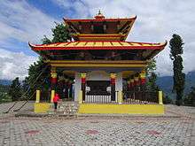
Another major site is Makwanpur Gadhi, east of the city, a fort of historical importance dating back to the unification of Nepal. King Prithvi Narayan Shah, who led the unification process, was married to the princess of Makwanpur, whose father was a king of the Sen dynasty that ruled the region. Historians say that this marriage was a political strategy by the king, who saw the benefit of an alliance with Makwanpur to encircle Kathmandu Valley.
Other nearby tourist attractions are:
- Chisapani Gadhi
- View Tower
- Pathivara Temple
- Palung Valley
- Daman Simbhanjyang
- Manakamana Temple
- Banaskhandi Temple
- Gumba Danda
- Kusmanda Sarowar Triveni Dham
- Bhutandevi Mandir
Transport
Hetauda is an hour's drive from the Nepalese border city of Birgunj, which is adjacent to Raxaul, India. Both of the existing highways to Kathmandu—the Tribhuvan Highway and the Mahendra Highway—traverse the city.
Hetauda's commercial prominence started with the construction of the Tribhuvan, the first highway built in the country. The eradication of malaria from the region's tropical forest paved the way for a settlement to grow. Another highway link that has been discussed for over a decade would, through a series of tunnels, reduce the driving distance to Kathmandu—currently 133 km via the Tribhuvan Highway—to less than 60 km. Such a route, if built, could make Hetauda a transit point for trade between the fast-growing economies of India and China. Currently, two unpaved roads provide a shorter route to Kathmandu for light vehicles; one goes through the villages of Fakhel and Pharping, and the other through Markhu and Sisneri. Likewise the project of national significance, Kathmandu-Nijgadh fast-track, approximately 77 kilometers long, if built in future is also likely to be connected providing linking road to the city.
The nearest airport is Simara Airport, about a 30-minute drive from the city.
Education
Education in Hetauda started with the establishment of Shree Bhutan Devi Secondary School (now Shree Bhutan Devi Higher Secondary School). Today, higher education institutions include:
- Shree Bansha Gopal College
- Makwanpur Multiple Campus
- Hetauda School of Management and Social Sciences
- Hetauda Campus
- Hetauda City College
- Solidarity International Academy
- Zenith International College
- Institute of Forestry, Hetauda
- Nawodit Nepal College
- Shree Jana Jyoti Higher Secondary School, Hetauda
- Mahendra Multiple Campus
Health Services
There are various hospitals in Hetauda.
- Hetauda Hospital(Governmental)
- Hetauda Community Eye Hospital
- Chure Hill Hospital
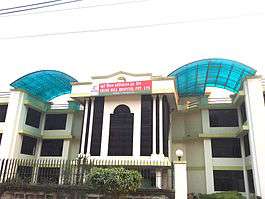
- Devi Hospital
- Hetauda Samudiyek Hospital
Hetauda Hospital is a government hospital located in the centre of Hetauda.
Chure Hill Hospital Private limited is a recently established multi speciality hospital located in Thanabharyang -11 hetauda. Chure Hill Hospital has been focussing on Orthopaedics and Neurosurgery in this region. This hospital has all facilities required for trauma patients as this region is very prone to road traffic accidents. Major Hospitals includes:
Hetauda Hospital
Chure Hill Hospital Private Limited - A Neuro Trauma Centre
Hetauda Eye Hospital
Media
Manakamana FM (92.9 MHz) was the first operating radio station of the city.Currently Hetauda has several community radio stations: Shakti FM (103.4 MHz), Radio Makwanpur FM (101.3), and Radio Kalash (89.4). There are other FM radio stations in the private sector, including Hetauda FM (96.6 MHz), Radio Thaha Sanchar (99.6), and Radio Sarobar (92.5). Radio Sarobar is the only comedy station broadcasting from Hetauda.
RAdio Sarobar 92.5 Mhz
Radio Sarobar 92.5 MHz Is the Only One Comedy Radio Station From makwanpur District. The Radio Station is established By Gagan Media Private Limited.
There are several local newspapers—Hetauda Sandesh, Hetauda Today, Samridha Samaj, Sajha Kura and Pradesh Dainik—and a television channel known as TeamTV.
2015 earthquake
According to Colin Stark at Columbia University, during the earthquake of 25 April 2015, "a part of India slid about one [foot] to 10 feet northwards and underneath Nepal in a matter of seconds. The part below Bihar slid under Nepal along a zone from Bharatpur, through Hetauda, to Janakpur."[3]
See also
References
- ↑ "Nepal Census 2001". Nepal's Village Development Committees. Digital Himalaya. Retrieved 9 December 2008.
- ↑ Let us be clear that Hetauda does not lie in Terai Region but in Inner Terai.
- ↑ "Part of India slid underneath Nepal". The Hindu. 29 April 2015. Archived from the original on 22 October 2016. Retrieved 22 October 2016.