Tribhuvan Highway
| |
|---|---|
| त्रिभूवन राजपथ | |
 | |
| Route information | |
|
Part of | |
| Length: | 158 km (98 mi) |
| Major junctions | |
| From: | Kathmandu |
|
| |
| To: |
527D
|
| Location | |
| Primary destinations: | Hetauda |
| Highway system | |
| Roads in Nepal | |
The Tribhuvan Highway (Nepali: त्रिभूवन राजपथ) connects the outskirts of Kathmandu, the capital of Nepal, with Birganj/Raxaul on the Nepal-India border.[1][2] NH 28 and NH 28A links Raxaul with Lucknow/Barauni and other locations in India.
History
Known informally as Byroad, the Tribhuvan Highway is the oldest of Nepal’s highways and links Naubise, 25 kilometres (16 mi) west of Kathmandu with the Indian border at Birganj/Raxaul.[2] It was named in memory of King Tribhuvan (1906–1955).
Its construction was completed with Indian assistance in 1956, and it provided the first serviceable road connection with India.[2] The first regular daily bus service on the highway was operated by Nepal Transport Service in 1959. The bus route ended at the railway station at Amlekhganj, from where travellers took the Nepal Government Railway (NGR) the rest of the way to Birgunj and Raxaul.
Before Tribhuvan Highway was built, travelers used the historic trade route passing through Kulekhani, Chitlang, Chandragiri Pass and Thankot.[3]
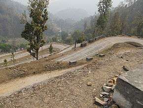
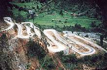
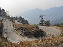
Route
The best stretch is through the Terai region. Thereafter, it is an unending series of climbs and descents through the Sivalik Hills north of Hetauda. Its total length extends to some 158 kilometres (98 mi) from north to south. It is 32 kilometres (20 mi) as the crow flies from Hetauda to Naubise, but Tribhuvan Highway makes it an astonishing 107 kilometres (66 mi).[2] At Naubise, the Tribhuwan Highway intersects the Prithvi Highway.[4]
Daman on Tribhuvan Highway has probably the finest view of the Himalayas extending on a good day from Dhaulagiri in the west to Everest in the east.[2]
Hetauda is the junction point of the Mahendra Highway and the Tribhuvan Highway.[2]
Fast track alternative
There are at least half a dozen routes to the Terai region via Makawanpur from the capital city, including Tribhuvan Highway, Kanti Highway, Ganesh Man Road, and Madan Bhandari Road. The four-lane fast track extending from the outer ring road in Kathmandu to Nijgadh in the Terai region will be the shortest and will only be 76 kilometres (47 mi). The track will have a tunnel of 1.3 km at Thingana of Makawanpur. It has been under construction since 2008.[5]
References
- ↑ "Highways in Nepal". Adarsha Nepal Adventure. Retrieved 2010-05-18.
- 1 2 3 4 5 6 Woodhatch, Tom. "Nepal handbook". p. 431. Google books. Retrieved 2010-05-18.
- ↑ "Kathmandu – Kulekhani". Rainbow trek and expedition. Retrieved 2010-05-18.
- ↑ "The Rajpath from Kathmandu biking route". Archived from the original on April 26, 2009. Retrieved 2010-05-18.
- ↑ "Kathmandu-Nijgadh road: New lifeline to prosperity". The Rising Nepal, 9 November 2008. Retrieved 2010-05-18.
| Wikimedia Commons has media related to Tribhuvan Highway. |
| Highways |
|
|---|---|