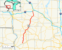
Wisconsin Highway 131
| ||||
|---|---|---|---|---|
 | ||||
| Route information | ||||
| Maintained by WisDOT | ||||
| Length: | 78.90 mi[1] (126.98 km) | |||
| Existed: | by 1927[2] – present | |||
| Major junctions | ||||
| South end: |
| |||
|
| ||||
| North end: |
| |||
| Location | ||||
| Counties: | Crawford, Vernon, Richland, Monroe | |||
| Highway system | ||||
| ||||

State Trunk Highway 131 (also called Highway 131, STH 131 or WIS 131) is a 78.9-mile (127.0 km) state highway in the U.S. state of Wisconsin. The highway is located in Wisconsin's Driftless Area, and it passes through Crawford, Vernon, Richland, and Monroe counties. It runs from WIS 60 near Wauzeka north to US Highway 12 (US 12) and WIS 16 in Tomah. WIS 131 is maintained by the Wisconsin Department of Transportation (WisDOT).
WIS 131 was designated in 1923 on a road between Ferryville and Gays Mills. It was realigned and several times in the next fifteen years, and it ultimately connected Wauzeka and Tomah in 1948. The highway was rerouted in northern Vernon County in the 1970s in expectation of a new dam on the Kickapoo River; however, when the dam project stalled in 1975, part of the rerouting between Rockton and Ontario was put on hold as well. WisDOT consequently performed very little maintenance on this section of WIS 131 for two decades after the dam project stopped, and it fell into disrepair. The state ultimately rebuilt the highway in the early 2000s, and the refurbished highway opened in 2003.
Route description
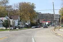
WIS 131 runs through hilly, rural terrain characteristic of the Driftless Area and Western Upland for its entire length. The route generally passes through farmland or wooded areas, though it also enters several small towns. WIS 131 begins in Crawford County at a 3-way intersection with WIS 60 northeast of Wauzeka and north of the Wisconsin River.[3] The highway heads in a generally northward direction from the intersection toward Steuben. WIS 131 begins to follow the Kickapoo River here, running within the river's deep river valley through Wilton. The highway enters Steuben from the southeast and heads east as Farris Street toward another 3-way intersection with WIS 179. WIS 131 heads north from this intersection as Midway Street for about a block before turning east and leaving Steuben as Railroad Street. The highway turns north again outside of Steuben and passes through Barnum, Petersburg and Bell Center before intersecting WIS 171 in Gays Mills. North of Gays Mills, WIS 131 heads north-northeast toward Soldiers Grove. The route enters Soldiers Grove as Church Street before turning east onto Pine Street and intersecting US 61. WIS 131 becomes concurrent with US 61 and heads north into Vernon County toward Readstown. The concurrency between WIS 131 and US 61 is part of the National Highway System; this portion of WIS 131 and its short concurrency with US 14 are the only parts of the highway which are part of the NHS.[4] WIS 131 and US 61 enter Readstown as Soldiers Grove Road and meet US 14 at a three-way intersection, where WIS 131 leaves US 61 and follows US 14 east for 0.4 miles (0.64 km). WIS 131 then leaves Readstown to the north as 4th Street. Outside of Readstown, WIS 131 cuts east and passes through the community of Kickapoo Center before turning back north toward Viola.[5] The highway enters Viola from the southwest as Commercial Street, passes Kickapoo High School[6] and briefly becomes concurrent with WIS 56. WIS 131 enters northwest Richland County while in Viola, and it remains in the county for a short distance northward.[7]
After it returns to Vernon County, WIS 131 heads north toward La Farge. The highway enters La Farge from the south as State Street and follows WIS 82 west for four blocks before turning north and leaving the village as Mill Street. The road passes through the Kickapoo Valley Reserve north of La Farge and remains in the reserve for most of its length through Ontario.[8] WIS 131 runs through unincorporated Rockton and bypasses Wildcat Mountain State Park to the west before entering the village of Ontario. The road crosses the Kickapoo River seven times on the 7.3 miles (11.7 km) between Rockton and Ontario.[5][9] In Ontario, WIS 131 meets WIS 33 and follows the route east briefly before turning north and entering Monroe County. The highway heads north into Wilton, where it becomes concurrent with WIS 71. WIS 131 follows WIS 71 northeast out of Wilton as Walker Street, and the two highways are concurrent for 3.4 miles (5.5 km). The two highways parallel the Elroy-Sparta State Trail for most of their concurrency, and the trail crosses over the roads before they separate at a 3-way intersection northeast of Wilton.[10] WIS 131 heads due north from this intersection toward Tomah. Between Wilton and Tomah, WIS 131 is designated as a Long Truck Route by WisDOT; trucks are not subject to weight or length restrictions on this section of the highway.[11] The highway intersects with Interstate 90 (I-90) in south Tomah and enters the city as Superior Avenue. This section of WIS 131 is the busiest of its entire route; according to WisDOT, the average daily traffic along this portion in 2006 was 7200 vehicles.[12] WIS 131 terminates at a four-way intersection with US 12 and WIS 16 in southern Tomah; the road continues northward as US 12.
History
WIS 131 was first designated between 1924 and 1927 on a route from WIS 35 near Ferryville to WIS 11 in Gays Mills. When WIS 11 was assigned to a different route before 1927, WIS 131 took on its route from Gays Mills north to WIS 27 in Soldiers Grove.[2][13] WIS 131 was extended further northward to La Farge in 1939 after a county highway was transferred to state control. In 1947, WisDOT switched the designations of WIS 131 and WIS 171 south and west of Gays Mills; WIS 131 was designated between Gays Mills and Wauzeka, and its original route between Ferryville and Gays Mills became WIS 171. WIS 131 was extended farther north to its current terminus in Tomah in 1948.[14]

In the 1970s, the state government planned to dam the Kickapoo River between La Farge and Ontario. As WIS 131 crossed the river eleven times between these towns, the state had to relocate the highway as well.[15] The first section of WIS 131 to be moved, between Ontario and Rockton, was realigned away from the river onto a route built to the east between 1978 and 1981.[16][17] The original section of the highway was abandoned so the dam could flood the area. This section was later turned into a recreational trail in the Kickapoo Valley Reserve.[18] The portion of WIS 131 between Rockton and Ontario was supposed to be moved east as well; the new highway would run north past Rockton to a realigned WIS 33, which it would follow into Ontario. The state built the first half-mile of this new route, but construction stopped on the new highway after the dam project was suspended after a cost-benefit analysis. The dam project ultimately failed, and the community did not resolve several land ownership issues until 2000. This pushed back any plans to resolve the relocation of WIS 131, and the road between Rockton and Ontario consequently received little to no maintenance during the intervening period.[19] The state first planned to complete the proposed relocation of the highway, but residents and environmentalists opposed this plan, and it eventually fell through. The state then planned a $20 million project to rebuild the existing stretch of WIS 131 instead; plans for this project were finalized in January 2000.[20] Environmentalists tried to stop this plan as well, and the Kickapoo Valley Stewardship Alliance sued WisDOT, claiming it had violated the Water Resources Development Act of 1996 and the Transportation Act of 1966.[20] The U.S. District Court for the Western District of Wisconsin struck down the lawsuit, and construction continued on the road. The improved section of WIS 131 was completed and dedicated in August 2003.[21]
Major intersections
| County | Location | mi[1] | km | Destinations | Notes |
|---|---|---|---|---|---|
| Crawford | Wauzeka | 0.0 | 0.0 | ||
| Steuben | 7.1 | 11.4 | |||
| Gays Mills | 19.3 | 31.1 | |||
| Soldiers Grove | 27.0 | 43.5 | South end of US 61 concurrency | ||
| Vernon | Readstown | 31.1 | 50.1 | North end of US 61 concurrency; west end of US 14 concurrency | |
| 31.5 | 50.7 | East end of US 14 concurrency | |||
| Viola | 38.9 | 62.6 | West end of WIS 56 concurrency | ||
| Richland | 39.2 | 63.1 | East end of WIS 56 concurrency | ||
| Vernon | La Farge | 45.2 | 72.7 | East end of WIS 82 concurrency | |
| 45.4 | 73.1 | West end of WIS 82 concurrency | |||
| Ontario | 58.1 | 93.5 | West end of WIS 33 concurrency | ||
| 58.2 | 93.7 | East end of WIS 33 concurrency | |||
| Monroe | Wilton | 66.0 | 106.2 | West end of WIS 71 concurrency | |
| 69.4 | 111.7 | East end of WIS 71 concurrency | |||
| Tomah | 78.3 | 126.0 | |||
| 78.9 | 127.0 | ||||
1.000 mi = 1.609 km; 1.000 km = 0.621 mi
| |||||
References
| Wikimedia Commons has media related to Wisconsin Highway 131. |
- 1 2 Google (2009-01-15). "Overview map of State Highway 131 Distances Between Interchanges" (Map). Google Maps. Google. Retrieved 2009-01-15.
- 1 2 Rand McNally Junior Auto Road Map: Wisconsin (Map). Rand McNally. 1927. Retrieved 2011-03-26.
- ↑ Crawford Co (PDF) (Map). Wisconsin Department of Transportation. Retrieved 2009-02-06.
- ↑ The National Highway System: Wisconsin (PDF) (Map). Federal Highway Administration. Retrieved 2009-02-21.
- 1 2 Vernon Co (PDF) (Map). Wisconsin Department of Transportation. Retrieved 2009-01-25.
- ↑ "Viola Area Education". Viola, Wisconsin. Retrieved 2009-01-26.
- ↑ Richland Co (PDF) (Map). Wisconsin Department of Transportation. Retrieved 2009-01-24.
- ↑ Kickapoo Valley Reserve Map (Map). Kickapoo Valley Reserve. Retrieved 2009-01-24.
- ↑ Google (2009-01-17). "overview map of State Highway 131 Between Rockton and Ontario" (Map). Google Maps. Google. Retrieved 2009-01-17.
- ↑ Monroe Co (PDF) (Map). Wisconsin Department of Transportation. Retrieved 2009-01-25.
- ↑ Wisconsin Long Truck Operators Map (PDF) (Map). Wisconsin Department of Transportation. Retrieved 2009-02-21.
- ↑ City of Tomah Annual Average Daily Traffic (PDF) (Map). Wisconsin Department of Transportation. Retrieved 2009-01-25.
- ↑ Rand McNally Auto Trails Map: Wisconsin (Map). Rand McNally. 1924. Retrieved 2011-03-26.
- ↑ Bessert, Chris. "Wisconsin Highways: Highways 130-139 (Highway 131)". Wisconsin Highways. Retrieved 2007-03-20.
- ↑ Bessert, Chris. "Wisconsin Highways: In Depth: STH-131 in the Kickapoo River Valley". Wisconsin Highways. Retrieved 2009-01-16.
- ↑ Stark (Map). Rockford Map Publishers, Inc. 1978. Retrieved 2011-03-26.
- ↑ Stark (Map). Rockford Map Publishers, Inc. 1981. Retrieved 2011-03-26.
- ↑ "Wild Area Now Wisconsin's - Tribe to Share In Control of Kickapoo Land". Wisconsin State Journal. 2000-12-30.
- ↑ Vanden Brook, Tom (1998-09-08). "River road is paved with apprehensions - All agree Kickapoo Valley route needs fixing, but plans are too big to some". Milwaukee Journal Sentinel.
- 1 2 Trevelen, Ed (2001-08-30). "Highway 131 Project to Continue - Opponents Wanted Court to Stop It". Wisconsin State Journal.
- ↑ Marks, Jerry (2004). "STH 131: Mobility in Harmony With Economic Stewardship" (PDF). Wisconsin Transportation Builder (Fall): 8–13. Archived from the original on May 5, 2006. Retrieved 2011-03-18.