Hogsett, West Virginia
| Hogsett, West Virginia | |
|---|---|
| Unincorporated community | |
 Hogsett, West Virginia | |
| Coordinates: 38°41′33″N 82°10′34″W / 38.69250°N 82.17611°WCoordinates: 38°41′33″N 82°10′34″W / 38.69250°N 82.17611°W | |
| Country | United States |
| State | West Virginia |
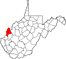
| County | Mason |
| Elevation | 558 ft (170 m) |
| Time zone | Eastern (EST) (UTC-5) |
| • Summer (DST) | EDT (UTC-4) |
| Area code(s) | 304 & 681 |
| GNIS feature ID | 1551470[1] |
Hogsett is an unincorporated community on the east bank of the Ohio River in Mason County, West Virginia, USA. It is located on West Virginia Route 2 some 10.7 miles (17.2 km) south-southwest of Point Pleasant[2] at the mouth of Flatfoot Creek. The community once had a post office, which is now closed.[3]
References
- ↑ "Hogsett". Geographic Names Information System. United States Geological Survey.
- ↑ Mason County, West Virginia General Highway Map (PDF) (Map). West Virginia Department of Transportation. 2011. p. 2. Retrieved February 17, 2013.
- ↑ "Hogsett Post Office (historical)". Geographic Names Information System. United States Geological Survey.
This article is issued from Wikipedia - version of the 9/4/2016. The text is available under the Creative Commons Attribution/Share Alike but additional terms may apply for the media files.