Hollins, Oldham

Coordinates: 53°31′19″N 2°07′26″W / 53.522°N 2.124°W
Hollins is an urban area in the town of Oldham in Greater Manchester, lying 1.7 miles south of Oldham town centre.
A former hamlet set amongst open moorland and farmland along Hollins Road, the 19th century growth of Oldham saw Hollins form a contiguous urban area with Hollinwood, Limeside, Garden Suburb, Werneth, Coppice and Copster Hill.[1]
The Merton Playing Fields is last remaining undeveloped land in the area.[2]
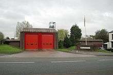
Hollins Fire Station is located in this area. It was opened in 1981 to replace the now demolished Werneth Fire Station.[3][4]
The area is served by Lyndhurst Primary School. The area was formerly served by Hollins Comprehensive School. See List of schools in Oldham.[5]
Hollins Methodist Church on Millgate has served the area since 1840.[6]
A Buddhist Temple, Ketumani Buddhist Vihara, has been established in Hollins since 2000.[7]
Transport
First Manchester provides the following bus services along Hollins Road:
180 providing services to Greenfield via Oldham and to Manchester via Failsworth.
184 to Huddersfield via Oldham and Uppermill and to Manchester via Failsworth.[8]
Stagecoach Manchester provides service 76 to Oldham and to Manchester via Limeside and Newton Heath.[9]
 |
Werneth | Werneth | Coppice | |
| Hollinwood | |
Copster Hill | ||
| ||||
| | ||||
| Limeside | Garden Suburb | Hathershaw |
References
- ↑ http://www.pixnet.co.uk/Oldham-hrg/newsletters/2012-03.html |Oldham Historical Research Group. Retrieved 3 December 2016
- ↑ http://sports-facilities.co.uk/sites/view/6007918 |Retrieved 4 December 2016
- ↑ http://www.manchesterfire.gov.uk/my_area/oldham/hollins/ |Hollins Fire Station Retrieved 3 December 2016
- ↑ http://oldhamfirebrigade.synthasite.com/history-of-the-brigade.php |Retrieved 3 December 2016>
- ↑ http://www.oldham.gov.uk/info/200545/education_history/670/the_story_of_education_in_oldham |Retrieved 3 December2016
- ↑ http://www.genuki.org.uk/big/eng/LAN/Hollinwood/Hollins |Retrieved 3 December 2016
- ↑ http://www.ketumati.org/index.php |Retrieved 3 December 2016
- ↑ https://www.firstgroup.com/greater-manchester/plan-journey/timetables/?operator=11&service=180/184&page=1&redirect=no| Retrieved 29 November 2016
- ↑ https://tis-kml-stagecoach.s3.amazonaws.com/PdfTimetables/XJAO076.pdf| Retrieved 29 November 2016