Hollo, Pennsylvania
| Hollo | |
|---|---|
| Unincorporated community | |
 Hollo Location within the state of Pennsylvania | |
| Coordinates: 40°43′22″N 75°17′44″W / 40.72278°N 75.29556°WCoordinates: 40°43′22″N 75°17′44″W / 40.72278°N 75.29556°W | |
| Country | United States |
| State | Pennsylvania |
| County | Northampton |
| Township | Lower Nazareth |
| Time zone | Eastern (EST) (UTC-5) |
| • Summer (DST) | EDT (UTC-4) |
| ZIP codes | 18045, 18064 |
| Area code(s) | 610 |
| GNIS feature ID | 1203827[1] |
Hollo (also Hallo, Niesky, or Nisky) is an unincorporated community in Northampton County, Pennsylvania, United States. Located at 40°43′22″N 75°17′44″W / 40.72278°N 75.29556°W (40.7228753, -75.2954566),[1] Hollo lies a short distance southeast (about one minute of latitude south and one minute of longitude east) of the borough of Nazareth,[2] at an altitude of 436 feet (133 m).[1] The intersection of Nazareth Road (Route 248) and Hollo Road lies in northeastern Lower Nazareth Township, southeast of Nazareth and northwest of the city of Easton.[3] Hollo is split between the Easton zip code of 18045 and the Nazareth zip code of 18064.
References
- 1 2 3 "Hollo, Pennsylvania". Geographic Names Information System. United States Geological Survey.
- ↑ U.S. Geological Survey Geographic Names Information System: Nazareth, Pennsylvania
- ↑ DeLorme. Pennsylvania Atlas & Gazetteer. 8th ed. Yarmouth: DeLorme, 2003, p. 68. ISBN 0-89933-280-3.
 |
Nazareth | Eastlawn Gardens | Stockertown, Tatamy | |
| Georgetown | |
Newburg Homes, Palmer Township | ||
| ||||
| | ||||
| Hecktown, Newburg | Newburg Homes, Bethlehem Township | Palmer Park |
Municipalities and communities of Northampton County, Pennsylvania, United States | ||
|---|---|---|
| Cities | 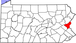 | |
| Boroughs | ||
| Townships | ||
| CDPs | ||
| Unincorporated communities | ||
| Footnotes | ‡This populated place also has portions in an adjacent county or counties | |
This article is issued from Wikipedia - version of the 9/4/2016. The text is available under the Creative Commons Attribution/Share Alike but additional terms may apply for the media files.