Home, Kansas
| Home, Kansas | |
|---|---|
| census-designated place | |
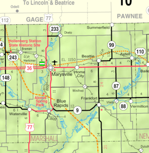 KDOT map of Marshall County (legend) | |
 Home | |
| Coordinates: 39°50′30″N 96°31′11″W / 39.84167°N 96.51972°WCoordinates: 39°50′30″N 96°31′11″W / 39.84167°N 96.51972°W | |
| Country | United States |
| State | Kansas |
| County | Marshall |
| Population (2000) | |
| • Total | 151 |
| Time zone | CST (UTC-6) |
| • Summer (DST) | CDT (UTC-5) |
| ZIP code | 66438 |
Home (also called Home City[1]) is an unincorporated community and census-designated place in southern Franklin Township, Marshall County, Kansas, United States.[2]
Its altitude is 1,345 feet (410 m), and it is located at 39°50′30″N 96°31′11″W / 39.84167°N 96.51972°W (39.8416678, -96.5197389).[1] Home lies along U.S. Route 36 – the Pony Express Highway – and a Union Pacific rail line, east of the city of Marysville,[2] the county seat of Marshall County.[3]
The town gets its name from the first post office, which was established in 1874 in someone's home.[4][5] The post office eventually was moved to its own building, which is now facing possible closure due to postal service austerity measures.[5]
References
- 1 2 U.S. Geological Survey Geographic Names Information System: Home, Kansas
- 1 2 DeLorme. Kansas Atlas & Gazetteer. 4th ed. Yarmouth: DeLorme, 2009, 24. ISBN 0-89933-342-7.
- ↑ "Find a County". National Association of Counties. Retrieved 2011-06-07.
- ↑ "Kansas Post Offices, 1828-1961 (archived)". Kansas Historical Society. Archived from the original on October 9, 2013. Retrieved 14 June 2014.
- 1 2 Marin, Robert (June 15, 2011). "Home, Kansas could lose its post office". KWCH-TV. Retrieved 14 June 2014.
Municipalities and communities of Marshall County, Kansas, United States | ||
|---|---|---|
| Cities | 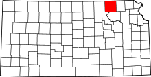 | |
| CDP | ||
| Unincorporated communities | ||
| Ghost towns | ||
| Townships | ||
This article is issued from Wikipedia - version of the 3/29/2016. The text is available under the Creative Commons Attribution/Share Alike but additional terms may apply for the media files.