Houten
| Houten | |||
|---|---|---|---|
| Municipality | |||
|
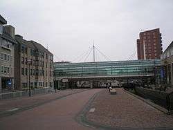
Town hall and station in Houten | |||
| |||
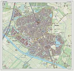
.svg.png) Location in Utrecht | |||
| Coordinates: 52°2′N 5°10′E / 52.033°N 5.167°ECoordinates: 52°2′N 5°10′E / 52.033°N 5.167°E | |||
| Country | Netherlands | ||
| Province | Utrecht | ||
| Government[1] | |||
| • Body | Municipal council | ||
| • Mayor | Wouter de Jong (CU) | ||
| Area[2] | |||
| • Total | 58.99 km2 (22.78 sq mi) | ||
| • Land | 55.41 km2 (21.39 sq mi) | ||
| • Water | 3.58 km2 (1.38 sq mi) | ||
| Elevation[3] | 2 m (7 ft) | ||
| Population (May 2014)[4] | |||
| • Total | 48,471 | ||
| • Density | 875/km2 (2,270/sq mi) | ||
| Time zone | CET (UTC+1) | ||
| • Summer (DST) | CEST (UTC+2) | ||
| Postcode | 3990–3999 | ||
| Area code | 030 | ||
| Website |
www | ||


Houten [ˈɦɔutə(n)] (![]() pronunciation ) is a municipality in the Netherlands, in the province of Utrecht.
pronunciation ) is a municipality in the Netherlands, in the province of Utrecht.
Population centres
The municipality consists of the following towns:
- 't Goy
- Houten
- Schalkwijk
- Tull en 't Waal
Houten (town)
The main town in the municipality is Houten, a commuter town about 9 km southeast of Utrecht. On 1 January 2012, the town had 48,314 (CBS) inhabitants. The built-up area was 5.08 km2 (1.96 sq mi) in area, and contained 18,451 residences.[5] The slightly larger statistical district of Houten had a population of about 39,100 in 2004.[6]
History of Houten
Remains of a Roman villa have been found in the old centre of Houten, made visible in a street pattern. There used to be a Roman villa on that spot. This building was discovered in the fifties. In the Dark Ages Houten took shape as a rural centre. The area of the municipality of Houten was divided in the so-called 'gerechten' (districts). The names of these districts are still in use: Schonauwen, Wulven, Waijen, Heemstede.
A lot of elements in present-day Houten are reminders of its history. Prominent in the old centre 'Het Oude Dorp' are the Roman Catholic Church (1884) and the Protestant Church (1563). The first accounts of this church date from the ninth century, the oldest parts of the church are probably from the eleventh century. Another prominent building is the restaurant/cafe 'De Engel', already mentioned in the 16th century as a tavern.[7]
Former access roads to the old centre are still recognisable by their names, such as the 'Odijkseweg' and 'Loerikseweg'. Houten had many orchards, but few have survived.
The expanding city 1966–1998
Modern Houten started to take shape in the last decades of the 20th century (1966–1998). It was first designated by the office of Wissing-Derks as a 'Groeikern' – a centre of growth – to meet the needs of the growing city of Utrecht. From the beginning urban planner-designer Robert Derks was involved with the development of the New Town Houten. In 1979 the construction of 10,000 dwellings started and the population grew from 4,000 to more than 30,000 late in the nineties.
Second designation as a centre of urban growth 1992–2015
Until 2015, some 7,000 new houses are being built in Houten-Zuid, following the same urban design principles as the existing Northern part of Houten, but with some differences. The body of water to the east is large in comparison with water bodies in the old parts of Houten. The pentagonal green zone in Houten-Zuid embracing the centre is different from the greenzone in Houten-Noord, which runs through the whole city in a linear structure, crossing the new city centre and with larger parks at either end. Another difference is that in some places cars share the road with bicycle paths (this concept was later applied in the northern part as well). The southern part was also designed by Robert Derks and his office for urban design Stedebouw BV.
Transport
Rail
Houten has two railway stations, Houten (opened in 1868, closed in 1935, re-opened on a different location in 1982 and restructured in 2010) and Houten Castellum (opened in 2010). These stations are served by local commuter trains to Utrecht (northbound) and Geldermalsen (southbound, with subsequent connections to Tiel and 's-Hertogenbosch/Breda). The railway has been doubled from two tracks to four, to accommodate for an extra stop at Castellum with a frequency of four trains per hour in each direction.
.jpg) Old railway building
Old railway building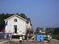 Relocation of old railway building (24 aug 2007)
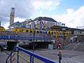 Houten Station (1982)
Bus
Busses travel to regional destinations.
Bike
Like most Dutch cities, Houten is well adapted to the high number of cyclists. A large network of bike paths make it convenient to cycle to various destinations and within the town the bike is the most popular mean of transport.
On October 29, 2008, Houten was chosen as Fietsstad 2008 — the top BikeCity of the Netherlands for 2008.[8]
Car
To the west, Houten has its own exit from the A27 motorway, and the N409 (single carriageway with bus lane) runs from Houten to Nieuwegein. To the east and south, there are only local roads, not designed for through traffic. A connection to the A12 motorway to the north is the N421 (single carriageway).
The only way to get from one district to another is via the ring road which circles around Houten, thus preventing through traffic in residential areas. Maximum speed on most of the ring road is 70 km/h (43 mph)[9]
Urban planning and architecture
Sustainable urban design
Houten is internationally known for its urban design. Because of the city structure, people are encouraged to travel by bike and train. Distinctive qualities of Houten include the accessibility of the railway station, green and water zones throughout the whole city, numerous soccer and basketball fields, high standard of accommodation for different groups and the child-friendly bicycle paths. It is one of the safest cities in the Netherlands. Cyclists and cars are able to avoid each other: an extensive network of bicycle tracks connects the different districts of the town, while cars have to go to the city ring road before they can go to another part of the city.
Thomas House is a small-scale housing complex in Houten for adults with intellectual disabilities, opened in 2013.[10]
Remarkable buildings in Houten
- Aluminiumcentre (Micha de Haas)
- Pyramid-shaped apartment complex Het Domein (Das brothers)
- Total petrol station (Samyn and Partners)
- Fire department (Samyn and Partners)
Famous people from Houten
- Chriet Titulaer (born 1943), television presenter and a writer of popular scientific material.
References
- ↑ "Wie is Wouter de Jong?" [Who is Wouter de Jong?] (in Dutch). Gemeente Houten. Retrieved 7 April 2014.
- ↑ "Kerncijfers wijken en buurten" [Key figures for neighbourhoods]. CBS Statline (in Dutch). CBS. 2 July 2013. Retrieved 12 March 2014.
- ↑ "Postcodetool for 3995DW". Actueel Hoogtebestand Nederland (in Dutch). Het Waterschapshuis. Retrieved 7 April 2014.
- ↑ "Bevolkingsontwikkeling; regio per maand" [Population growth; regions per month]. CBS Statline (in Dutch). CBS. 26 June 2014. Retrieved 24 July 2014.
- ↑ Statistics Netherlands (CBS), Bevolkingskernen in Nederland 2001 . Statistics are for the continuous built-up area.
- ↑ Statistics Netherlands (CBS), Gemeente Op Maat 2004: Houten .
- ↑ Houten te voet of the fiets, publication by the municipality of Houten (2001)
- ↑ http://www.fietsstad2008.nl/houten_thema_verkeersveilighei.php
- ↑ Gemeente Houten – Veelgestelde vragen over verkeer (in Dutch, frequently asked questions about traffic)
- ↑ "Foto's: Koningin Máxima bezoekt Thomashuis in Houten".
External links
| Wikimedia Commons has media related to Houten. |
 |
Utrecht | |
Bunnik | |
| Nieuwegein | |
|||
| ||||
| | ||||
| Lek Vianen |
Lek Culemborg (GE) |
Wijk bij Duurstede |
Municipalities of Utrecht | ||
|---|---|---|
 | ||
| ||