Hudson River Waterfront Walkway

The Hudson River Waterfront Walkway, also known as the Hudson River Walkway,[1] is an ongoing and incomplete project located on Kill van Kull and the western shore of Upper New York Bay and the Hudson River, implemented as part of a New Jersey state-mandated master plan to connect the municipalities from the Bayonne Bridge to the George Washington Bridge with an urban linear park and provide contiguous unhindered access to the water's edge.
There is no projected date for its completion, though large segments have been built or incorporated into it since its inception.[2][3] The southern end in Bayonne may eventually connect to the Hackensack RiverWalk, another proposed walkway along Newark Bay and Hackensack River on the west side of the Hudson County peninsula, and form part of a proposed Harbor Ring around the harbor. Its northern end is in Palisades Interstate Park, allowing users to continue along the river bank and alpine paths to the New Jersey/New York state line and beyond. (A connection to the Long Path, a 330-mile (530 km) hiking trail with terminus near Albany, is feasible.)
As of 2007, eleven miles (18 km) of walkway have been completed, with an additional five miles (8 km) designated HRWW along Broadway in Bayonne. A part of the East Coast Greenway, or ECG, a project to create a nearly 3000-mile (4828 km) urban path linking the major cities along the Atlantic coast runs concurrent with the HRWW.[4][5]
The walkway is showing signs of ageing with some pilings on which it is built succumbing to marine worms and damage done by Hurricane Sandy which undermined bedding.[6]
Route
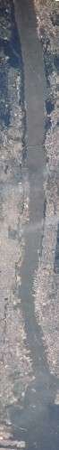
The distance of the walkway from beginning to end is approximately 18.5 miles (29.8 km) as it follows the contour of the shore-line.[7] It traverses established residential and commercial areas, re-developed piers, wetland preservation zones, industrial and transportation infrastructure, and is dotted with public and private marinas. Expansive views of the water and the New York skyline can be seen from most of its length. It will eventually pass through the following municipalities (which have combined population of approximately 550,000).
- Bayonne (2000 population of 61,842)
- Jersey City (240,055)
- Hoboken (50,005)
- Weehawken (13,501)
- West New York (45,768)
- Guttenberg (10,807)
- North Bergen (58,092)
- Edgewater (9,635)
- Fort Lee (35,461)
History
A walkway or promenade along the northeastern New Jersey waterfront was first discussed at a state level in the late 1970s. In 1988, the New Jersey Department of Environmental Protection created the Coastal Zone Management Rules, which outlined the regulations and specifications for its construction. They require anyone building within 100 feet (30 m) of the water's edge to provide a minimum of 30 feet (9.1 m) wide open, public space along it. Construction must be permitted by the agency and paid for by the developer. In 1999, the National Association of Home Builders and the New Jersey Builders Association challenged the obligation in court as an unfair taking of private property under eminent domain, saying that property owners should be compensated as specified by the "Takings clause" of the Fifth Amendment. A federal judge rejected the suit, upholding a state rule that requires property owners to provide access to the waterfront.[8][9][10]
Obstacles and advantages
- The land upon which the walkway is built (or to be built) is held privately and publicly. Much is used by the Port Authority of New York and New Jersey.
- Privately held land is not required to have a walkway until it is re-developed. In some instances, some gated-developments have provided only minimal perpendicular access which is often not clearly indicated.
- The topography is diverse, with canals or coves that come quite far inland, requiring the walkway to either go around them or cross them with bridges.
- Transportation, industrial, or maritime infrastructure is found along the route, and construction of HRWW could interfere with their operation and public safety.
- Much of the land which the walkway crosses had maritime or industrial uses and became obsolete or was abandoned. Chapel Avenue provides access at Caven Point in Jersey City, but the area south of there is still actively used for these purposes.
- Each municipality implements and enforces its own zoning rules, and often negotiates with developers with a local rather than regional interest, and have other municipal open-space projects to which funds must be dedicated.
- Most housing and commercial real-estate developers see the advantage of providing access to the water as an amenity.
- Some sections of the walkway are easily accessible by public transportation, such as the Hudson-Bergen Light Rail, NY Waterway ferries, and New Jersey Transit bus terminals at Hoboken Terminal and Exchange Place.
Parks and points of interest


- Bergen Point
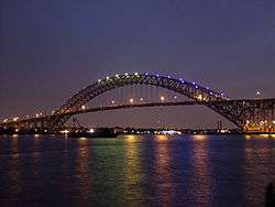
- Bayonne Bridge, world's third-longest steel arch bridge
- Kill van Kull Park
- Bradys Dock
- former Standard Oil Tank Cleaning Services/Texaco Tank Farm
- Port Johnson
- Constable Hook
- Robbins Reef Light
- Bayonne Golf Course - site of most extensive brownfields reclamation project in New Jersey
- The Peninsula at Bayonne Harbor, site of former Military Ocean Terminal at Bayonne
- Tear of Grief - gift from Russia commemorating September 11, 2001
- Cape Liberty Cruise Port
- Port Jersey
- Waterfront Observation Tower and bird sanctuary for endangered least tern
- Greenville Yards
- Liberty National Golf Course-southern section
- Caven Point
- Caven Athletic Complex
- US Army Corps of Engineers station
- Port Liberte
- Liberty State Park-Caven Point Branch
- US Army Reserve Center
- Liberty National Golf Course-main section
- Liberty State Park
- Black Tom, site of World War I sabotage explosion
- Central Railroad of New Jersey Terminal
- Hornblower Cruises ferry to Ellis Island and Liberty Island
- Liberty Science Center
- Morris Canal Big Basin
- Paulus Hook
- Liberty State Park-Peninsula Park
- Morris Canal-Little Basin
- Colgate Clock, with claims to being the world's largest
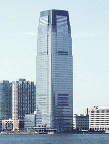
- Goldman Sachs Tower, tallest building in New Jersey.
- Exchange Place, downtown Jersey City's "financial" district
- Katyń Memorial
- Pavonia
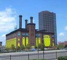
- Hudson and Manhattan Railroad Powerhouse
- Harsimus Cove[11] site one of early European settlements
- Pavonia/Newport, site of Erie Railroad's Pavonia Terminal (1861–1958)
- Holland Tunnel Ventilation Tower, with twin across river
- 13 panel exhibition of history of environment, development of lower Hudson River
- Long Slip
- Hoboken
- Hoboken Terminal, 1908 national landmark and major transportation hub
- Pier A
- Marineview Plaza, urban renewal project in the Brutalist style
- Stevens Institute of Technology
- Castle Point, serpentine rock bluff
- Sybil's Cave, long-abandoned site of spring and inspiration for Edgar Allan Poe's "The Mystery of Marie Roget"
- Elysian Park
- Hoboken Historical Museum
- Hudson Tea Building, massive former Lipton Tea plant
- North Hudson
- Weehawken Cove, where Henry Hudson's Half Moon anchored in 1609
- Lincoln Harbor
- Riva Point
- The Atrium, home to events sponsored by the proposed Hudson River Performing Arts Center
- King's Bluff, at the foot of which the Burr-Hamilton duel took place in 1804
- Lincoln Tunnel Ventilation Towers
- Weehawken Municipal Athletic Fields
- West Shore Railroad Tunnel, used by Hudson-Bergen Light Rail
- Weehawken Port Imperial
- Kestrel, a historic steam yacht
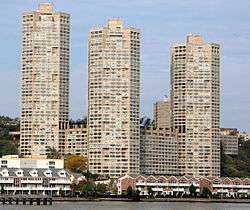
- Galaxy Towers, a trio of octagonal highrises built in the late 1970s
- Palisades Medical Center
- Edgewater
- Edgewater Driving Range
- Hess Oil Tank Farm
- Edgewater Cemetery, with 19th and 20th century graves
- The Binghamton, decommissioned ferry and registered national historic place
- Mitsuwa Marketplace
- Municipal Building
- Edgewater Landing
- Veterans Park/Edgewater Community Center-site of plaque commemorating Vriessendael, the first European settlement in what would become contemporary Bergen County
- Edgewater Colony
- Palisades Interstate Park
- Mt. Constitution, atop which sits Fort Lee Historic Park, site of George Washington's 1776 encampment Fort Constitution[12][13][14]
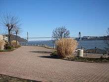
- George Washington Bridge
See also
- Hudson Waterfront
- Hudson River Park
- Riverside Park (Manhattan)
- Manhattan Waterfront Greenway
- East River Greenway
- Brooklyn Bridge Park
References
- ↑ LaMarca, Stephen. "Experience the Hudson River Walkway" The Union City Reporter. September 18, 2011. pages 4 and 7
- ↑ Kelly, Mike (October 16, 2008). "Hudson River Walkway is far from finished". The Record. Retrieved 2009-02-23.
- ↑ Hortillosa, Summer Dawn. "PHOTOS: Hudson River Walkway tour to showcase waterfront's beauty, history". NJ.com. September 13, 2011.
- ↑ "HRWW and East Coast Greenway". Liberty Water Gap Trail. accessed September 16, 2011.
- ↑ "East Coast Greenway". Vanasse Hangen Brustlin, Inc. accessed September 16, 2011.
- ↑ Hack, Charles (March 9, 2013). "New Jersey Land Conservation Rally will address Hudson River waterfront today at NJIT". The Jersey Journal. Retrieved 2013-03-10.
- ↑ Hevesi, Dennis (August 15, 1999). "A River Walk's Piecemeal Birth". The New York Times.
- ↑ "Judge Upholds Law on Waterfront Access". The New York Times. August 19, 1999. Accessed October 7, 2007.
- ↑ Hevesi, Dennis (August 15, 1999). "A River Walk's Piecemeal Birth". New York Times. Retrieved 2009-02-23.
- ↑ "Daily poll: Do you believe coastal access rules should be changed?". NJ.com/The Jersey Journal. March 24, 2011
- ↑ Applebome, Peter. "Our Towns; A Promenade and a Trail, Ready to Meet a Greenway", The New York Times, August 3, 2005. Accessed October 7, 2007.
- ↑ "Revolution: Pre-Revolution". Retrieved 2009-03-11.
- ↑ Winson, Terrie (March 2002). "Lenni Lenape". Retrieved 2009-03-12.
- ↑ Adams, Hudson River Guidebook, p. 106
External links
- Bergen County HRWW
- Global Marine Terminal
- Bayonne masterplan
- Hudson River Waterfront
- NY Harbour Bike Route
Municipalities and communities of Hudson County, New Jersey, United States | ||
|---|---|---|
| Cities | 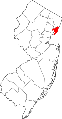 | |
| Borough | ||
| Towns | ||
| Townships | ||
Coordinates: 40°34′16″N 74°13′02″W / 40.571066°N 74.217281°W