Humboldt, Saskatchewan
| Humboldt | ||
|---|---|---|
| City | ||
| City of Humboldt | ||
|
City of Humboldt welcome sign | ||
| ||
| Nickname(s): 'Boldt, The 'Boldt | ||
 Humboldt | ||
| Coordinates: 52°12′07″N 105°07′23″W / 52.20194°N 105.12306°WCoordinates: 52°12′07″N 105°07′23″W / 52.20194°N 105.12306°W | ||
| Country | Canada | |
| Province | Saskatchewan | |
| Established | 1875 | |
| Incorporated (town) | April 1, 1907 | |
| Incorporated (city) | November 7, 2000 | |
| Government | ||
| • Mayor | Rob Muench, (2016) | |
| • Humboldt City Council | Larry Jorgenson, Sandy Weyland, Roger Nordick, Michael Behiel, Owen Hopfner, Lorne Pratchler[1] | |
| • MLA, Humboldt | Donna Harpauer (SKP), (2011) | |
| • MP, Saskatoon—Humboldt | Brad Trost (CPC), (2011) | |
| Area | ||
| • Total | 11.66 km2 (4.50 sq mi) | |
| Elevation | 548.60 m (1,799.87 ft) | |
| Population (2011) | ||
| • Total | 5,678 | |
| • Density | 421.9/km2 (1,093/sq mi) | |
| Time zone | CST (UTC-6) | |
| Area code(s) | 306 | |
| Highways |
| |
| Railways | Canadian National | |
| Website | http://www.humboldt.ca | |
| [2][3] | ||

Humboldt is a Canadian city located in the province of Saskatchewan, 113 km east of Saskatoon at the junction of Highway 5 and Highway 20. The city is surrounded by the Rural Municipality of Humboldt No. 370.
History
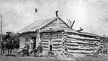
Named after German explorer Alexander von Humboldt, Humboldt began as a telegraph station located on the Carlton Trail, a wagon route used in the early days of Western Canada as a route from Fort Garry (Winnipeg) to Fort Edmonton. The name "Humboldt" was approved in 1875 for a site in the North West Territories along the Canadian Pacific Telegraph Line at which a repair station was built (8 km south-west of the present city site). Built in 1878, the Humboldt Telegraph Station[4] played an integral part in communications for the developing West.[5]
With the Métis uprising led by Louis Riel taking place at Batoche just 100 km northwest, Humboldt became the communication link between Prime Minister John A. Macdonald and his forces in the West, thus a site of strategic significance. General Frederick Middleton arrived in April 1885 with 950 soldiers, established a garrison at the station, and used it as his base for scouting operations. At that time, the Humboldt station was crucial, since the telegraph line further west was periodically cut – so Humboldt was the last secure link to the East.[6]
On May 1, 1885, Humboldt became the site of a large supply depot under Maj. Lt.-Colonel G. T. Denison of the Governor Generals' Body Guard. A combined force of approximately 460 men built an elaborate series of entrenchments, converting the station into a fortified military encampment to protect the supplies. The troops left Humboldt in July 1885. The area was also the site of the first stagecoach robbery in Western Canada.[7] Parts of the Carlton Trail in the form of wagon tracks/ruts still exist in the Humboldt area.
Humboldt in its beginnings was primarily German Catholic. It became the largest settlement in the Territorial Abbey of Saint Peter-Muenster also called St. Peter's Colony[8] established by Benedictine monks from St John's Abbey in Collegeville, Minnesota.[9] Immigration to the area from both the Northern Plains states of the USA and Germany was promoted by the German American Land Company. Many immigrants from the German Empire settled in areas in and around Humboldt such as Muenster, Fulda, Pilger, St Gregor and Englefeld. Immigrants from the Russian Empire who were ethnic Germans settled in the area west of Humboldt and south of the hamlet of Carmel.[10]
After being established as a community, Humboldt became an important location in Saskatchewan previously known as the "Heart of the Sure Crop District" for its reliable growing weather, which led the town to become a centre for farming equipment and supply businesses.
Climate
Humboldt experiences a humid continental climate (Köppen climate classification Dfb).[11]and falls into the USDA Plant Hardiness Zone 3a.[12] It is a great distance from any large bodies of water, and thus lacks any moderating influences on its climate. The latitudinal difference of Saskatchewan can typically explain a 6–8 °C difference mean in annual temperatures across the province. Winters sometimes can be being very cold and long with short warm summers.
The highest temperature ever recorded in Humboldt was 41.1 °C (106 °F) on 19 July 1941.[13] The coldest temperature ever recorded was −50.6 °C (−59 °F) on 12 January 1916.[14]
| Climate data for Humboldt | |||||||||||||
|---|---|---|---|---|---|---|---|---|---|---|---|---|---|
| Month | Jan | Feb | Mar | Apr | May | Jun | Jul | Aug | Sep | Oct | Nov | Dec | Year |
| Record high °C (°F) | 6.0 (42.8) |
15.0 (59) |
20.6 (69.1) |
32.2 (90) |
36.0 (96.8) |
39.0 (102.2) |
41.1 (106) |
38.3 (100.9) |
34.4 (93.9) |
31.1 (88) |
21.1 (70) |
10.0 (50) |
41.1 (106) |
| Average high °C (°F) | −11.9 (10.6) |
−8.3 (17.1) |
−1.9 (28.6) |
9.1 (48.4) |
17.2 (63) |
21.4 (70.5) |
23.9 (75) |
23.8 (74.8) |
17.1 (62.8) |
9.0 (48.2) |
−2.5 (27.5) |
−9.8 (14.4) |
7.3 (45.1) |
| Daily mean °C (°F) | −16.9 (1.6) |
−13.3 (8.1) |
−6.6 (20.1) |
3.3 (37.9) |
10.4 (50.7) |
15.2 (59.4) |
17.4 (63.3) |
16.9 (62.4) |
10.8 (51.4) |
3.5 (38.3) |
−6.8 (19.8) |
−14.3 (6.3) |
1.6 (34.9) |
| Average low °C (°F) | −21.8 (−7.2) |
−18.1 (−0.6) |
−11.3 (11.7) |
−2.5 (27.5) |
3.6 (38.5) |
8.9 (48) |
10.9 (51.6) |
10.1 (50.2) |
4.4 (39.9) |
−2.1 (28.2) |
−11.1 (12) |
−18.8 (−1.8) |
−4.0 (24.8) |
| Record low °C (°F) | −50.6 (−59.1) |
−46.7 (−52.1) |
−46.1 (−51) |
−33.0 (−27.4) |
−16.7 (1.9) |
−10.0 (14) |
−4.4 (24.1) |
−6.7 (19.9) |
−12.2 (10) |
−24.0 (−11.2) |
−36.5 (−33.7) |
−43.9 (−47) |
−50.6 (−59.1) |
| Average precipitation mm (inches) | 15.1 (0.594) |
9.0 (0.354) |
15.1 (0.594) |
23.3 (0.917) |
43.2 (1.701) |
67.6 (2.661) |
82.2 (3.236) |
51.0 (2.008) |
37.2 (1.465) |
22.5 (0.886) |
12.1 (0.476) |
14.4 (0.567) |
392.5 (15.453) |
| Source: Environment Canada[15][16] | |||||||||||||
Demographics


As reported in the 2011 census, Humboldt grew by 13.6% since 2006 for a population of 5,678.
| Major ethnic groups, 2011 | ||
|---|---|---|
| Ethnic group[17] | Population | Percent |
| German | 3,165 | 57.4% |
| English | 905 | 16.4% |
| Ukrainian | 860 | 15.6% |
| Irish | 640 | 11.6% |
| Scandinavian | 635 | 11.5% |
| French | 520 | 9.4% |
| Scottish | 495 | 9% |
| Russian | 350 | 6.4% |
| Total respondent population | 5.510 | 100% |
| Canada census – Humboldt, Saskatchewan community profile | |||
|---|---|---|---|
| 2011 | 2006 | 2001 | |
| Population: | 5,678 (+13.6% from 2006) | 4,998 (-3.2% from 2001) | 5,161 (1.7% from 1996) |
| Land area: | 13.46 km2 (5.20 sq mi) | 11.72 km2 (4.53 sq mi) | 11.66 km2 (4.50 sq mi) |
| Population density: | 421.9/km2 (1,093/sq mi) | 426.4/km2 (1,104/sq mi) | 442.6/km2 (1,146/sq mi) |
| Median age: | 45.2 (M: 42.6, F: 47.1) | 45.3 (M: 42.7, F: 47.9) | 41.9 (M: 39.5, F: 44.5) |
| Total private dwellings: | 2,567 | 452 | 2,313 |
| Median household income: | $40,640 | $37,174 | |
| References: 2011[18] 2006[19] 2001[20] | |||

Economy
About 95% of all goods produced in the province directly depend on its basic resources (grains, livestock, oil and gas, potash, uranium and timber) and their refined products.
Wheat, canola, flax, peas, rye, lentils, canary seed and barley are mainly grown in the area. Beef cattle production, pork production – as well as other livestock – are significant for the community. With many farmers in the area, agricultural-related businesses were formed. Some services offered are in trucking and financial management, finance, business services, wholesale trade, transportation, etc. These jobs became significant for the farming community as well as the manufacturing community.
Attractions
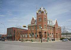
Humboldt has a number of heritage buildings listed on the Canadian Register of Historic Places. They include the Canadian National Railways (Canadian Northern Railway) Station (built in 1905),[21] a Post Office (built in 1911–1912),[22] the Humboldt Provincial Court House (built in 1914–1920).[23] and the Humboldt Water Tower (built in 1914).[24]
The Humboldt Post Office is a National Historic Site of Canada (built in 1911–1912). It houses the Humboldt and District Museum and Gallery.[25]
Marysburg Assumption Church is located 16 km (10 miles) north of Humboldt.[26] Mount Carmel Shrine is located 23 km (14 miles) west and St. Peter's Abbey is 10 km (6 miles) east of the city.
The Humboldt Murals located in the town centre depict historic scenes.
Festivals
- The Summer Sizzler is held in late-June of each year. The event features a midway, demolition derby, cabaret, slo-pitch tournament, tractor pull, Sizzler Strut Marathon and live on-stage entertainment. On the opening day, there is a parade through downtown and a pancake breakfast at Centennial Park.
- Canada Day celebrations occur every year on July 1 at Water Ridge Park and include live musical entertainment as well as a fireworks display.
- The Humboldt StreetFest is held in mid-August and is organized by the Humboldt Downtown Business Improvement District.
Sports and recreation
Humboldt is home to over 30 acres of parks and open spaces as well as a growing pedestrian trails and pathways system. There are eleven parks around the city, including: A.E. Kilcher Park, Bill Brecht Memorial Park, Carl Schenn Recreational Park, Centennial Park, Civic Park, Glenn Hall Park, Peace Park, St. Augustine School Grounds, St. Dominic School Grounds, Water Ridge Park and Wilf Chamney Park.
Situated 4 miles (6.4 km) west of Humboldt along Highway 5 and two miles (3 km) south is the Kloppenburg Wildlife Refuge. It consists of 160 acres (0.65 km2) which have never been cultivated.
The Uniplex is Humboldt's recreational facility featuring a curling rink, a skating and hockey rink, an indoor aquatic centre, a fitness room and a convention hall. On the Uniplex grounds is Centennial Park with six ball diamonds, a skateboard park and the Rodeo and Exhibition Grounds.
An 18-hole golf course is located next to Water Ridge Park and the Humboldt Historical Park and Campground.
Humboldt is home to the Humboldt Broncos of the Saskatchewan Junior Hockey League.
Churches
Humboldt has ten churches: Humboldt Alliance Church, St. John's Lutheran, St. Andrew's Anglican Church, St. Augustine Catholic Church, Living Word Ministries, All Saints Ukrainian Catholic Church, Humboldt Bible Church, Westminster United Church of Canada, First Baptist Church and Kingdom Hall of Jehovah's Witnesses.[1]
Education
| Humboldt Collegiate Institute | |
|---|---|
| Address | |
|
509 8th Avenue Humboldt, Saskatchewan, S0K 2A1 Canada | |
| Information | |
| Type | Secondary |
| School board |
Horizon School Division No. 205 Greater Saskatoon Catholic Schools |
| Principal | Cory Popoff |
| Vice Principal | Jacquie Bergerman |
| Vice Principal | Shaun Gardiner |
| Grades | Grade 9 to Grade 12 |
| Enrollment | 371[27] (2016) |
| Education system | Public/Separate |
| Language | English |
| Website | Humboldt Collegiate Institute |
| Humboldt Public School | |
|---|---|
| Address | |
|
509 8th Avenue Humboldt, Saskatchewan, S0K 2A1 Canada | |
| Information | |
| Type | Elementary |
| School board | Horizon School Division No. 205 |
| Principal | Dave Hill |
| Vice Principal | Darlene Popoff |
| Grades | Pre-Kindergarten to Grade 8 |
| Enrollment | 288[27] (2016) |
| Education system | Public |
| Language | English |
| Website | Humboldt Public School |
| St. Augustine School | |
|---|---|
| Address | |
|
1103 8th Avenue Humboldt, Saskatchewan, S0K 2A1 Canada | |
| Information | |
| Type | Elementary |
| Religious affiliation(s) | Catholic |
| Opened | 1907[28] |
| School board | Greater Saskatoon Catholic Schools |
| Principal | Cal Theisen |
| Vice Principal | Cathy Korte-Monz |
| Grades | Kindergarten to Grade 8 |
| Enrollment | 310[27] (2016) |
| Education system | Separate |
| Language | English |
| Website | St. Augustine School |
| St. Dominic School | |
|---|---|
| Address | |
|
706 2nd Avenue South Humboldt, Saskatchewan, S0K 2A1 Canada | |
| Information | |
| Type | Elementary |
| Religious affiliation(s) | Catholic |
| Opened | 1959[29] |
| School board | Greater Saskatoon Catholic Schools |
| Principal | Dallas Puto |
| Vice Principal | Chad Knaus |
| Grades | Kindergarten to Grade 8 |
| Enrollment | 242[27] (2016) |
| Education system | Separate |
| Language | English |
| Website | St. Dominic School |
Humboldt has three elementary schools: two Catholic (St. Augustine and St. Dominic) and one public (Humboldt Public School).
It has one public high school, Humboldt Collegiate Institute. It is co-managed by Horizon School Division No. 205 and Greater Saskatoon Catholic Schools.[30] The Humboldt Collegiate Institute has Senior & Junior Volleyball teams (boys & girls), Senior & Junior Basketball Teams (boys & girls), Soccer (boys & girls), Badminton, Golf, Cross-Country, Track & Field and a 9-man Football program known as HCI Mohawks. The Mohawks won provincial championships in 1975, 1996, 1997, 2008 and 2010.
Carlton Trail Regional College has its headquarters in Humboldt.
Infrastructure
Transportation
The city is served by Highway 5 and Highway 20.
Humboldt Airport, (TC LID: CJU4), is located 1 nautical mile (1.9 km; 1.2 mi) south of the city.
Health care
Humboldt lies within the Saskatoon Health Region and is served by the Humboldt District Health Complex. This state-of-the-art complex houses a medical clinic and four pharmacies in addition to local dental, chiropractic, home care, optometry, physiotherapy as well as health and wellness services.[31]
Government
Humboldt City Council
The Humboldt City Council is the municipal governing body for the city. The council consists of the mayor and six councillors. The current council sits between 2012 and 2016. The last civic election was held on October 24, 2012. Historically, the mayor and councillors were elected to three-year terms; however, the terms have increased to four years. Mayor Malcolm Eaton was returned by acclamation in the 2012 election.[32]
| 2012 Election Results (Councillors) | ||
| Candidate | Votes | % |
|---|---|---|
| Leon Fleischhacker | 1,041 | |
| Rob Muench | 961 | |
| Sandy Weyland | 745 | |
| Larry Jorgenson | 687 | |
| Linda Mattock | 627 | |
| Roger Nordick | 620 | |
| Owen Hopfner | 612 | |
| Larry Sunderland | 581 | |
| Kenton Flavel | 548 | |
| Francis Kunz | 406 | |
| Marc Dredhart | 146 | |
| Turnout | 28% | |
Legislative Assembly of Saskatchewan
The City of Humboldt is the largest centre in the provincial electoral district of Humboldt. Donna Harpauer of the Saskatchewan Party is the current MLA for the riding.
Humboldt will join the new riding of Humboldt-Watrous in the next provincial election that is scheduled to take place in late 2015.
Member of Parliament
The City of Humboldt is currently within the federal electoral district of Saskatoon-Humboldt which is represented by Brad Trost of the Conservative Party of Canada.
Due to the Canadian federal electoral redistribution, 2012 Humboldt will move into the rural-only riding of Humboldt—Warman—Martensville—Rosetown for the 42nd Canadian federal election that is scheduled for October 2015.
Notable people
Notable people who were born, grew up in or established their fame in Humboldt:
- Kelly Bates, former CFL guard and now Head Coach with the Simon Fraser Clan
- Al Duerr, former mayor of Calgary, Alberta
- Jillian Gallays, wrestler
- Glenn "Mr. Goalie" Hall, former professional ice hockey goaltender. Stanley Cup Champion and Hockey Hall of Fame inductee
- Ross Lonsberry, professional ice hockey player, two-time Stanley Cup Champion with the Philadelphia Flyers
- Otto Lang, Rhodes Scholar, Law School Dean, Federal Cabinet Minister, and Executive
- Brad Lauer, former NHL forward and current assistant coach with the Anaheim Ducks
- Kyle McLaren, former NHL defenceman
- Brendan Witt, former NHL defenceman
- Nathan Paetsch, former NHL defenceman
- William Dutton, 2014 Olympian 500m and 1000m long-track speed skater
- Jeremy Wotherspoon, speed skater with 67 World Cup wins
- Lyndon Rush, 2010 Olympian Bronze Medal four-man bobsleigh and 2014 Olympian Canadian bobsledder
- Brianne Theisen-Eaton, 2012 and 2016 Olympian, Heptathlete and Canadian record-holder in the women's pentathlon, 2016 Olympic bronze medallist (heptathlon)
- Rusty Malinoski, professional wakeboarder
- David Schmidtz, political philosopher
References
- 1 2 "City of Humboldt". City of Humboldt. Retrieved 2009-10-02.
- ↑ National Archives, Archivia Net. "Post Offices and Postmasters". Archived from the original on October 6, 2006. Retrieved 29 September 2013.
- ↑ Government of Saskatchewan, MRD Home. "Municipal Directory System (City of Humboldt)". Archived from the original on January 15, 2016. Retrieved 29 September 2013.
- ↑ A Line Through the Wilderness
- ↑ "Humboldt History". City of Humboldt. Retrieved 2009-10-02.
- ↑ "District of Saskatchewan Map 1885" (PDF). University of Regina. Retrieved 2013-12-01.
- ↑ "The Legacy of St. Peter's Colony(P.12)". Retrieved 2013-01-06.
- ↑ "St. Peter's Colony Map". Retrieved 2013-01-06.
- ↑ "Territorial Abbey of Saint Peter-Muenster". Retrieved 2013-09-18.
- ↑ "Encyclopedia of Saskatchewan (GERMAN SETTLEMENTS)". Encyclopedia of Saskatchewan. Canadian Plains Research Center, University of Regina. 2006. Retrieved 2013-09-18.
- ↑ "Climate Regions" (Image (JPE) FTP). FTP Home - Natural Resources Canada Archives. Natural Resources Canada. Retrieved 9 April 2016.
- ↑ "Plant Hardiness Zone by Municipality". Natural Resources Canada. Government of Canada. Retrieved 26 March 2016.
- ↑ Environment Canada , accessed 11 July 2016
- ↑ Environment Canada
- ↑ Environment Canada , accessed 11 July 2016
- ↑ Environment Canada , accessed 11 July 2016
- ↑ "NHS Profile, Humboldt, CY, Saskatchewan, 2011 (The sum of the ancestries in this table is greater than the total population estimate because a person may report more than one ancestry (ethnic origin) in the National Household Survey.)". 2011. Retrieved 2014-07-27.
- ↑ "2011 Community Profiles". Canada 2011 Census. Statistics Canada. July 5, 2013. Retrieved 2011-03-10.
- ↑ "2006 Community Profiles". Canada 2006 Census. Statistics Canada. March 30, 2011. Retrieved 2011-03-10.
- ↑ "2001 Community Profiles". Canada 2001 Census. Statistics Canada. February 17, 2012. Retrieved 2011-03-10.
- ↑ "Canadian National Railways (Canadian Northern Railway) Station". Retrieved 2013-09-18.
- ↑ "Post Office". Retrieved 2013-09-18.
- ↑ "Provincial Court House". Retrieved 2013-09-18.
- ↑ "Water Tower". Retrieved 2013-09-18.
- ↑ "Humboldt Post Office National Historic Site of Canada". Retrieved 2013-09-18.
- ↑ "Marysburg Assumption Church". Retrieved 2013-09-18.
- 1 2 3 4 Active List of Saskatchewan Schools/Programs (PDF), retrieved 2016-11-28
- ↑ Celebrating a Century of Faith and Learning - A History of Saskatoon's Catholic Schools. Greater Saskatoon Catholic Schools. 2015. p. 196. ISBN 978-0-9947443-0-2.
- ↑ Celebrating a Century of Faith and Learning - A History of Saskatoon's Catholic Schools. Greater Saskatoon Catholic Schools. 2015. p. 198. ISBN 978-0-9947443-0-2.
- ↑ HCI Joint Operations Committee, retrieved 2015-06-30
- ↑ "Saskatoon Health Region (Humboldt District Health Complex)". Retrieved 2014-07-27.
- ↑ humboldt.ca
External links
| Wikimedia Commons has media related to Humboldt, Saskatchewan. |
-
 Humboldt travel guide from Wikivoyage
 - Official website
- Map of Humboldt at Statcan
- Humboldt - Encyclopedia of Saskatchewan
- Humboldt & District Museum & Gallery
 |
Wakaw | Annaheim Lake Lenore |
| |
| Carmel Bruno Meacham Saskatoon |
|
Muenster St. Gregor Englefeld Watson | ||
| ||||
| | ||||
| Burr Guernsey Lanigan |
Leroy |
| Subdivisions | |
|---|---|
| Communities | |
| Cities | |
| Topics |
|
| |