Hunter, Kansas
| Hunter, Kansas | |
|---|---|
| City | |
 Location within Mitchell County and Kansas | |
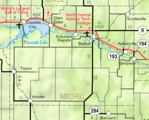 KDOT map of Mitchell County (legend) | |
| Coordinates: 39°14′5″N 98°23′45″W / 39.23472°N 98.39583°WCoordinates: 39°14′5″N 98°23′45″W / 39.23472°N 98.39583°W | |
| Country | United States |
| State | Kansas |
| County | Mitchell |
| Area[1] | |
| • Total | 0.21 sq mi (0.54 km2) |
| • Land | 0.21 sq mi (0.54 km2) |
| • Water | 0 sq mi (0 km2) |
| Elevation | 1,598 ft (487 m) |
| Population (2010)[2] | |
| • Total | 57 |
| • Estimate (2012[3]) | 57 |
| • Density | 270/sq mi (110/km2) |
| Time zone | Central (CST) (UTC-6) |
| • Summer (DST) | CDT (UTC-5) |
| ZIP code | 67452 |
| Area code | 785 |
| FIPS code | 20-33525 [4] |
| GNIS feature ID | 0472482 [5] |
Hunter is a city in Mitchell County, Kansas, United States. As of the 2010 census, the city population was 57.[6]
History
The first post office in Hunter was established in 1895.[7] It was named for Al Hunter, an early settler.[8] Hunter was incorporated in 1915.[9]
Geography
Hunter is located at 39°14′5″N 98°23′45″W / 39.23472°N 98.39583°W (39.234632, -98.395944).[10] According to the United States Census Bureau, the city has a total area of 0.21 square miles (0.54 km2), all of it land.[1]
Climate
The climate in this area is characterized by hot, humid summers and generally mild to cool winters. According to the Köppen Climate Classification system, Hunter has a humid subtropical climate, abbreviated "Cfa" on climate maps.[11]
Demographics
| Historical population | |||
|---|---|---|---|
| Census | Pop. | %± | |
| 1920 | 205 | — | |
| 1930 | 219 | 6.8% | |
| 1940 | 199 | −9.1% | |
| 1950 | 236 | 18.6% | |
| 1960 | 229 | −3.0% | |
| 1970 | 150 | −34.5% | |
| 1980 | 135 | −10.0% | |
| 1990 | 116 | −14.1% | |
| 2000 | 77 | −33.6% | |
| 2010 | 57 | −26.0% | |
| Est. 2015 | 56 | [12] | −1.8% |
| U.S. Decennial Census | |||
2010 census
As of the census[2] of 2010, there were 57 people, 33 households, and 15 families residing in the city. The population density was 271.4 inhabitants per square mile (104.8/km2). There were 61 housing units at an average density of 290.5 per square mile (112.2/km2). The racial makeup of the city was 98.2% White and 1.8% Native American. Hispanic or Latino of any race were 1.8% of the population.
There were 33 households of which 15.2% had children under the age of 18 living with them, 36.4% were married couples living together, 6.1% had a female householder with no husband present, 3.0% had a male householder with no wife present, and 54.5% were non-families. 45.5% of all households were made up of individuals and 30.3% had someone living alone who was 65 years of age or older. The average household size was 1.73 and the average family size was 2.33.
The median age in the city was 63.5 years. 14% of residents were under the age of 18; 5.4% were between the ages of 18 and 24; 14.1% were from 25 to 44; 17.6% were from 45 to 64; and 49.1% were 65 years of age or older. The gender makeup of the city was 43.9% male and 56.1% female.
2000 census
As of the census[4] of 2000, there were 77 people, 41 households, and 23 families residing in the city. The population density was 363.6 people per square mile (141.6/km²). There were 57 housing units at an average density of 269.2 per square mile (104.8/km²). The racial makeup of the city was 98.70% White and 1.30% Native American.
There were 41 households out of which 19.5% had children under the age of 18 living with them, 46.3% were married couples living together, 7.3% had a female householder with no husband present, and 43.9% were non-families. 43.9% of all households were made up of individuals and 24.4% had someone living alone who was 65 years of age or older. The average household size was 1.88 and the average family size was 2.48.
In the city the population was spread out with 15.6% under the age of 18, 5.2% from 18 to 24, 18.2% from 25 to 44, 28.6% from 45 to 64, and 32.5% who were 65 years of age or older. The median age was 56 years. For every 100 females there were 87.8 males. For every 100 females age 18 and over, there were 91.2 males.
The median income for a household in the city was $19,000, and the median income for a family was $27,708. Males had a median income of $15,625 versus $11,250 for females. The per capita income for the city was $13,424. There were no families and 5.3% of the population living below the poverty line, including no under eighteens and 7.1% of those over 64.
References
- 1 2 "US Gazetteer files 2010". United States Census Bureau. Archived from the original on January 24, 2012. Retrieved 2012-07-06.
- 1 2 "American FactFinder". United States Census Bureau. Retrieved 2012-07-06.
- ↑ "Population Estimates". United States Census Bureau. Archived from the original on June 17, 2013. Retrieved 2013-05-29.
- 1 2 "American FactFinder". United States Census Bureau. Archived from the original on September 11, 2013. Retrieved 2008-01-31.
- ↑ "US Board on Geographic Names". United States Geological Survey. 2007-10-25. Retrieved 2008-01-31.
- ↑ "2010 City Population and Housing Occupancy Status". U.S. Census Bureau. Archived from the original on July 21, 2011. Retrieved October 10, 2011.
- ↑ "Kansas Post Offices, 1828-1961 (archived)". Kansas Historical Society. Archived from the original on October 9, 2013. Retrieved 15 June 2014.
- ↑ "Profile for Hunter, Kansas". ePodunk. Retrieved 16 June 2014.
- ↑ From a Souvenir Booklet for the National Midwest Tour of the Horseless Carriage Club (1954). "Histories of Mitchell County Towns". Blue Skyways. Kansas State Library. Retrieved 15 June 2014.
- ↑ "US Gazetteer files: 2010, 2000, and 1990". United States Census Bureau. 2011-02-12. Retrieved 2011-04-23.
- ↑ Climate Summary for Hunter, Kansas
- ↑ "Annual Estimates of the Resident Population for Incorporated Places: April 1, 2010 to July 1, 2015". Retrieved July 2, 2016.
External links
| Wikimedia Commons has media related to Hunter, Kansas. |
- City
- Schools
- USD 299, local school district
- Maps
- Hunter City Map, KDOT
Municipalities and communities of Mitchell County, Kansas, United States | ||
|---|---|---|
| Cities | 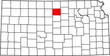 | |
| CDP | ||
| Unincorporated community | ||
| Townships |
| |
| Footnotes | ‡This populated place also has portions in an adjacent county or counties | |