Hutchinson, Oregon
| Hutchinson, Oregon | |
|---|---|
| Unincorporated community | |
 Hutchinson, Oregon  Hutchinson, Oregon | |
| Coordinates: 44°58′18″N 117°58′40″W / 44.97167°N 117.97778°WCoordinates: 44°58′18″N 117°58′40″W / 44.97167°N 117.97778°W | |
| Country | United States |
| State | Oregon |
| County | Baker |
| Elevation | 3,383 ft (1,031 m) |
| Time zone | Pacific (PST) (UTC-8) |
| • Summer (DST) | PDT (UTC-7) |
| Area code(s) | 458 and 541 |
| GNIS feature ID | 1136404[1] |
Hutchinson is an unincorporated community in Baker County, Oregon, United States.[1] It is about 5 miles (8 km) northwest of Haines, west of U.S. Route 30.[2][3]
Hutchinson was a station on the route of the Union Pacific Railroad's Huntington subdivision named for a local family.[2] The line was originally owned by the Oregon Railroad and Navigation Company.[4] Hutchinson post office was founded in 1900 with James H. Hutchinson as the first postmaster.[2] The post office closed in 1902.[2]
References
- 1 2 "Hutchinson". Geographic Names Information System. United States Geological Survey. November 28, 1980. Retrieved November 16, 2016.
- 1 2 3 4 McArthur, Lewis A.; McArthur, Lewis L. (2003) [1928]. Oregon Geographic Names (7th ed.). Portland, Oregon: Oregon Historical Society Press. p. 491. ISBN 978-0875952772.
- ↑ Oregon Atlas & Gazetteer (7th ed.). Yarmouth, Maine: DeLorme. 2008. p. 79. ISBN 0-89933-347-8.
- ↑ U.S. Coast and Geodetic Survey (1905). Report of the Superintendent of the Coast and Geodetic Survey Showing the Progress of Work from July 1, 1904 to June 30, 1905. Washington, D.C.: U.S. Government Printing Office. p. 225. Retrieved December 26, 2013.
External links
- Images of Hutchinson from Flickr
Municipalities and communities of Baker County, Oregon, United States | ||
|---|---|---|
| Cities | 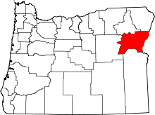 | |
| Unincorporated communities | ||
| Ghost towns | ||
This article is issued from Wikipedia - version of the 11/16/2016. The text is available under the Creative Commons Attribution/Share Alike but additional terms may apply for the media files.