Iowa Highway 333
| ||||
|---|---|---|---|---|
 | ||||
| Route information | ||||
| Maintained by Iowa DOT | ||||
| Length: | 1.558 mi[1] (2.507 km) | |||
| Major junctions | ||||
| West end: |
| |||
| East end: |
| |||
| Location | ||||
| Counties: | Fremont | |||
| Highway system | ||||
| ||||

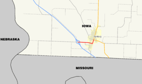
Iowa Highway 333 (Iowa 333) is a short highway in southwestern Iowa. It serves as a connector route between Interstate 29 and U.S. Highway 275 (US 275) in Hamburg. Formerly spanning two counties, Iowa 333 is the second-shortest state highway in Iowa; only Iowa Highway 165 is shorter.
Route description

Iowa Highway 333 begins at Interstate 29, exit 1, approximately 2 miles (3.2 km) from the Missouri state line. Just 500 yards (460 m) from the western end, Iowa 333 crosses a BNSF Railway line.[2] It enters Hamburg's west side along North Street. Iowa 333 meets Main Street in Hamburg at a four-way stop. Main Street connects to Missouri Route V 1 mile (1.6 km) south of town. Two blocks east of Main Street, Iowa 333 turns north onto Washington Street towards U.S. Route 275. Iowa 333 passes Hamburg's Clayton Field between A Street and D Street before ending at E Street. US 275 northbound continues north on Washington Street and southbound US 275 travels east on E Street.
History
Iowa Highway 333 was originally a 9-mile-long (14 km) spur route from U.S. Route 59 to Northboro. By the late 1940s, Iowa 333 extended 34 miles (55 km) from U.S. Route 275 to U.S. Route 71 near College Springs.[3] In 1970, all of Iowa 333 west of US 59 was turned over to Fremont County. In 1980, however, Iowa 333 was extended west to Interstate 29 from US 59 and turned over to Fremont and Page County east of US 59. Iowa 333 was 14 miles (23 km) long between 1980 and 2003. On 1 July 2003, all of Iowa 333 east of US 275 was turned over to Fremont County. Most of Iowa 333's former route is known as County Road J64.
Major intersections
The entire route is in Hamburg, Fremont County.
| mi[1] | km | Destinations | Notes | ||
|---|---|---|---|---|---|
| 0.000 | 0.000 | ||||
| 1.558 | 2.507 | ||||
| 1.000 mi = 1.609 km; 1.000 km = 0.621 mi | |||||
References
- 1 2 "2009 Volume of Traffic on the Primary Road System of Iowa" (PDF). Iowa Department of Transportation. January 1, 2009. Retrieved October 15, 2010.
- ↑ Iowa Department of Transportation (1 July 2008). "Iowa State Railroad Map" (PDF). Retrieved 5 December 2016.
- ↑ Road and Reference Atlas (Map) (1947 ed.). 1:1,077,120. Rand McNally & Company. 1947. pp. 42–43.