Interstate 29 in Iowa
| ||||
|---|---|---|---|---|
|
Iowa's Interstate Highways with I-29 highlighted in red. | ||||
| Route information | ||||
| Maintained by Iowa DOT | ||||
| Length: | 151.826 mi[1] (244.340 km) | |||
| Existed: | October 1, 1958[2] – present | |||
| History: | Under construction 1958–1972 | |||
| Tourist routes: |
| |||
| Major junctions | ||||
| South end: |
| |||
| ||||
| North end: |
| |||
| Location | ||||
| Counties: | ||||
| Highway system | ||||
| ||||
.svg.png)
_map.svg.png)
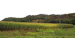
In the U.S. state of Iowa, Interstate 29 (I-29) is a north–south Interstate Highway which closely parallels the Missouri River. I-29 enters Iowa from Missouri near Hamburg and heads to the north-northwest through the Omaha-Council Bluffs and the Sioux City areas. It exits the state by crossing the Big Sioux River into South Dakota. For its entire distance through the state, it runs on the flat land between the Missouri River and the Loess Hills.
I-29 was built in sections over a period of 15 years. When there was a shortage of male workers, female workers stepped in to build a twenty-mile (32 km) section near Missouri Valley. Between Council Bluffs and Sioux City, I-29 replaced U.S. Route 75 (US 75) as the major route in western Iowa. As a result of I-29's creation, US 75 south of Sioux City was relocated into Nebraska.
Route description
Interstate 29 enters Iowa south of Hamburg. The interstate heads northwest, where it meets Iowa Highway 333 (Iowa 333) at a diamond interchange. From Hamburg, I-29 continues to the northwest for seven miles (11 km) where it meets Iowa 2 three miles (4.8 km) east of Nebraska City, Nebraska. North of the Iowa 2 interchange, the interstate straightens out to the north; interchanges serving Percival, Thurman, and Bartlett are spaced out every four and a half miles (7.2 km). At the US 34 interchange near Glenwood, I-29 is joined by US 275.[1]
North of Glenwood, I-29 / US 275 continue north towards Council Bluffs. The two routes meet Iowa 370, which crosses into Nebraska providing access to Offutt Air Force Base in Bellevue, Nebraska. Near Lake Manawa, US 275 splits away from I-29 at the Iowa 92 interchange. three-quarters mile (1.2 km) north of the split, the interstate is joined from the east by Interstate 80. The two interstates head west together through southern Council Bluffs for three miles (4.8 km). When the two interstates split at a Y interchange, I-80 immediately crosses the Missouri River into Nebraska, and I-29 immediately turns to the north. Two miles (3.2 km) to the north is a modified Y interchange with US 6 and the eastern end of I-480.[1]
North of Council Bluffs, I-29 is joined by I-680 near Crescent. The two interstates travel north together for nine miles (14 km) before I-680 splits off to the east near Loveland. I-29 continues north for four miles (6.4 km) to Missouri Valley, where it intersects US 30. North of Missouri Valley, the interstate turns to the northwest towards Modale and then straightens out again south of Mondamin, where I-29 meets the western end of Iowa 127. From Mondamin, it travels north for 23 miles (37 km) to the Iowa 175 interchange at Onawa, passing Little Sioux and Blencoe.[1]

North of Onawa, I-29 continues northwest for fifteen miles (24 km) towards Sloan, where it meets the western end of Iowa 141. As it approaches the Sioux City metro area, it passes the Sioux Gateway Airport at Sergeant Bluff. At the Singing Hills Boulevard interchange, northbound is joined by southbound U.S. Route 75 Business (US 75 Bus.). One mile (1.6 km) later, US 75 Bus. ends at the cloverleaf interchange with US 20 / US 75, which is also the eastern end of Interstate 129.[1]
For the next three miles (4.8 km) north of the I-129 interchange, I-29 runs closely, as close as 200 feet (61 m), to the Missouri River. The interstate follows the curve of the river and turns to the west. It meets Gordon Drive, which carries US 20 Bus. US 20 Bus. traffic is directed onto the interstate for one-half mile (0.80 km) before it exits via a volleyball interchange which represents the national northern end of U.S. Route 77.[1] I-29 continues west along the Missouri River, and after the Big Sioux River converges into the Missouri, I-29 follows the Big Sioux. Shortly before it crosses the Big Sioux into South Dakota, Iowa 12 splits away to the north.[3]
History
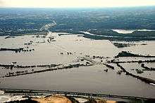
Construction of Interstate 29 began in the late 1950s in the Sioux City area. The first section to open, a three-mile-long (4.8 km) stretch from the Big Sioux River to the then-US 20 / US 77 bridge across the Missouri River, opened around October 1, 1958. In September 1961, I-29 was extended across the Big Sioux River to South Dakota. On April 1, 1962, some of the northbound directional spans collapsed into the Big Sioux River at the South Dakota state line as a result of flooding and bridge scour.[4][5][6]
North of Council Bluffs, a twenty-mile (32 km) section to Missouri Valley opened in November 1958. By December 1967, the two sections were connected, creating 100 miles (160 km) of continuous interstate highway.[2] Due to a shortage of male workers, at least 20 women were enlisted to help build this section of I-29. The women were paid $2.00 hourly ($14.00 hourly in 2016 dollars[7]), the same wage as men would have earned.[8]
Construction of I-29 in the Council Bluffs area was completed in 1970 and the route was open to Glenwood in the same year. Additional interchanges were added in the Sioux City and Council Bluffs areas between 1970 and 1971. The last thirty miles (48 km) of interstate were constructed and opened in sections over the next two years; the last section opened on December 15, 1972.[2]
In 1973, US 34 was expanded to four lanes near Glenwood, which resulted in US 34 being rerouted onto I-29 for three miles (4.8 km).[2] In 2003, US 275 was rerouted onto I-29 from the same interchange near Glenwood northward to Iowa 92 at Council Bluffs. The former US 275 alignment was turned over to Mills and Pottawattamie Counties.[9]
Much of I-29 was built next to existing highways, most notably US 75. When the section of I-29 opened between Council Bluffs and Missouri Valley, US 75 was rerouted onto I-29.[10] When construction connecting the Sioux City and Council Bluffs segments was completed, US 75 was again rerouted onto I-29.[11] In the mid-1980s, US 75, from Council Bluffs to Sioux City, was completely rerouted out of Iowa, instead extending up the former US 73 corridor in Nebraska.[12]
Exit list
| County | Location | mi[1] | km | Exit[13] | Destinations | Notes |
|---|---|---|---|---|---|---|
| Fremont | Washington Township | 0.000 | 0.000 | Continuation into Missouri | ||
| 1.811 | 2.915 | 1 | Access to Grape Community Hospital | |||
| Benton Township | 10.144 | 16.325 | 10 | |||
| 15.458 | 24.877 | 15 | ||||
| Scott Township | 19.917 | 32.053 | 20 | Formerly Iowa 145 | ||
| 24.447 | 39.344 | 24 | ||||
| Mills | Plattville Township | 32.386 | 52.120 | 32 | Pacific Junction, Plattsmouth | Formerly US 34 |
| 35.477 | 57.095 | 35 | Southern end of US 275 overlap | |||
| Saint Marys–Oak township line | 43.805 | 70.497 | 42 | Formerly Iowa 370 | ||
| Pottawattamie | Council Bluffs | 47.865 | 77.031 | 47 | Northern end of US 275 overlap | |
| 48.526 | 78.095 | 48 | Southern end of I-80 and US 6 overlaps; I-80 exit 4 | |||
| 49.230 | 79.228 | 3 | South Expressway – Council Bluffs, Business District, Lake Manawa | Formerly Iowa 192, exit number follows I-80 | ||
| 50.683 | 81.566 | 1B | S. 24th Street – Mid-America Center | Exit number follows I-80 | ||
| 51.644 | 83.113 | 51 | Northern end of I-80 overlap; I-80 exit 1A | |||
| 52.378 | 84.294 | 52 | Nebraska Avenue | |||
| 53.199 | 85.615 | 53A | 9th Avenue / Harrah's Boulevard | |||
| 53.777 | 86.546 | 53B | Northern end of US 6 overlap; northbound left exit; no eastbound exit | |||
| 54.204 | 87.233 | 54A | Avenue G | Southbound exit and entrance only | ||
| 54.623 | 87.907 | 54B | N. 35th Street | Northbound exit and entrance only | ||
| 55.715 | 89.665 | 55 | N. 25th Street | |||
| 56.917 | 91.599 | 56 | N. 16th Street – Council Bluffs, Business District | Southbound left exit and northbound entrance only, formerly Iowa 192 | ||
| Crescent Township | 61.966 | 99.725 | 61 | Southern end of I-680 overlap; signed as exits 61A (east) and 61B (west) | ||
| Crescent–Rockford township line | 66.465 | 106.965 | 66 | Honey Creek | ||
| Rockford Township | 71.623 | 115.266 | 71 | Northern end of I-680 overlap | ||
| 71.988 | 115.853 | 72 | Loveland | Pottawattamie CR G12 (west) and CR G14 (east) | ||
| Harrison | Missouri Valley | 75.786 | 121.966 | 75 | Access to Community Memorial Hospital | |
| Taylor Township | 82.088 | 132.108 | 82 | |||
| Morgan Township | 89.309 | 143.729 | 89 | |||
| Little Sioux Township | 95.714 | 154.037 | 95 | |||
| Monona | Sherman Township | 105.347 | 169.540 | 105 | ||
| Onawa | 112.326 | 180.771 | 112 | |||
| Lincoln–Lake township line | 120.210 | 193.459 | 120 | |||
| Woodbury | Sloan Township | 127.571 | 205.306 | 127 | ||
| Salix | 133.970 | 215.604 | 134 | Salix (CR K25) | ||
| 135.708 | 218.401 | 135 | Port Neal Landing (CR D51) | |||
| Sergeant Bluff | 141.194 | 227.230 | 141 | |||
| Sioux City | 143.413 | 230.801 | 143 | |||
| 144.473 | 232.507 | 144 | Signed as exits 144A (east/north) and 144B (west/south); I-129 exits 1A-B | |||
| 147.476 | 237.340 | 147A | Floyd Boulevard | |||
| 148.050 | 238.263 | 147B | No northbound entrance; access to Mercy Medical Center and St. Luke's Regional Medical Center | |||
| 148.493 | 238.976 | 148 | No southbound exit; southbound access is part of exit 149 | |||
| 149.081 | 239.923 | 149 | Northbound exit signed as Hamilton Blvd. only | |||
| 151.365 | 243.598 | 151 | ||||
| Big Sioux River | 151.826 | 244.340 | Iowa–South Dakota state line | |||
| Union | Dakota Dunes | Continuation into South Dakota | ||||
1.000 mi = 1.609 km; 1.000 km = 0.621 mi
| ||||||
References
- 1 2 3 4 5 6 7 "2009 Volume of Traffic on the Primary Road System of Iowa" (PDF). Iowa Department of Transportation. January 1, 2009. Retrieved September 8, 2010.
- 1 2 3 4 Completion Map of Interstate System (PDF) (Map). Iowa Department of Transportation. January 1, 1982. Retrieved September 8, 2010.
- ↑ Sioux City, Iowa (PDF) (Map). Iowa Department of Transportation. 2010. Retrieved September 8, 2010.
- ↑ "Rain, storms follow weekend of storms; stir fears of floods". Lodi News-Sentinel. United Press International. April 2, 1962. p. 5. Retrieved January 29, 2015.
- ↑ "I-29 bridge collapse". Sioux City Journal. April 22, 2012. Retrieved January 29, 2015.
- ↑ Richardson, E. V.; Lagasse, P. F. (1999). Stream Stability and Scour at Highway Bridges. American Society of Civil Engineers. p. 57.
- ↑ Federal Reserve Bank of Minneapolis Community Development Project. "Consumer Price Index (estimate) 1800–". Federal Reserve Bank of Minneapolis. Retrieved October 21, 2016.
- ↑ "Can't get men, paving contractor is hiring women". Toledo Blade. Associated Press. October 13, 1967. p. 5. Retrieved September 8, 2010.
- ↑ Iowa State Highway Map (PDF) (Map). Iowa Department of Transportation. 2004. § B2. Retrieved September 8, 2010.
- ↑ Iowa State Highway Map (PDF) (Map). Iowa State Highway Commission. 1959. § L2:M3. Retrieved September 8, 2010.
- ↑ Iowa State Highway Map (PDF) (Map). Iowa State Highway Commission. 1969. § G1:L3. Retrieved September 8, 2010.
- ↑ Iowa State Highway Map (Map). Iowa Department of Transportation. 1985. § A5:B3.
- ↑ Transportation Map (PDF) (Map). Iowa Department of Transportation. 2010. Retrieved 2010-09-08.
External links
| Previous state: Missouri |
Iowa | Next state: South Dakota |