Ironside, Oregon
| Ironside, Oregon | |
|---|---|
| Unincorporated community | |
|
Abandoned building in Ironside | |
 Ironside, Oregon  Ironside, Oregon | |
| Coordinates: 44°19′28″N 117°56′41″W / 44.32444°N 117.94472°WCoordinates: 44°19′28″N 117°56′41″W / 44.32444°N 117.94472°W | |
| Country | United States |
| State | Oregon |
| County | Malheur |
| Elevation | 3,783 ft (1,153 m) |
| Time zone | Pacific (PST) (UTC-8) |
| • Summer (DST) | PDT (UTC-7) |
| ZIP code | 97908 |
| Area code(s) | 541 |
| GNIS feature ID | 1136412[1] |

Ironside is an unincorporated community in Malheur County, Oregon, United States. Ironside is located on U.S. Route 26 46 miles (74 km) northwest of Vale. Ironside has a post office with ZIP code 97908.[2]
Climate
According to the Köppen Climate Classification system, Ironside has a semi-arid climate, abbreviated "BSk" on climate maps.[3]
References
- ↑ "US Board on Geographic Names". United States Geological Survey. 2007-10-25. Retrieved 2008-01-31.
- ↑ ZIP Code Lookup
- ↑ Climate Summary for Ironside, Oregon
External links
- Photos of Ironside from Panoramio
Municipalities and communities of Malheur County, Oregon, United States | ||
|---|---|---|
| Cities | 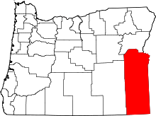 | |
| CDPs | ||
| Other unincorporated communities | ||
| Ghost town | ||
This article is issued from Wikipedia - version of the 7/31/2016. The text is available under the Creative Commons Attribution/Share Alike but additional terms may apply for the media files.