Jefferson Township, Andrew County, Missouri
| Jefferson Township | |
|---|---|
| Township | |
 | |
| Coordinates: 39°53′08″N 094°47′12″W / 39.88556°N 94.78667°WCoordinates: 39°53′08″N 094°47′12″W / 39.88556°N 94.78667°W | |
| Country | United States |
| State | Missouri |
| County | Andrew |
| Area | |
| • Total | 32.63 sq mi (84.50 km2) |
| • Land | 32.34 sq mi (83.75 km2) |
| • Water | 0.29 sq mi (0.75 km2) 0.88% |
| Elevation[1] | 892 ft (272 m) |
| Population (2010) | |
| • Total | 4,646 |
| • Density | 144/sq mi (55.5/km2) |
| FIPS code | 29-36710[2] |
| GNIS feature ID | 0766224 |
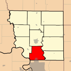
Jefferson Township is one of ten townships in Andrew County, Missouri, United States. As of the 2010 census, its population was 4,646.[3]
Jefferson Township was established in 1846, and named after Thomas Jefferson.[4]
Geography
Jefferson Township covers an area of 32.81 square miles (85.0 km2) and contains one incorporated settlement, Country Club. It shares part of its southern border with the city of St. Joseph in neighboring Buchanan County. The township contains four cemeteries: Fairview, Green, Ladd and Vanschoiack.
The streams of Crowley Creek, Dillon Creek and Mace Creek run through this township.
References
- ↑ "US Board on Geographic Names". United States Geological Survey. 2007-10-25. Retrieved 2008-01-31.
- ↑ "American FactFinder". United States Census Bureau. Retrieved 2008-01-31.
- ↑ "Geographic Identifiers: 2010 Demographic Profile Data (G001): Jefferson township, Andrew County, Missouri". U.S. Census Bureau, American Factfinder. Retrieved June 21, 2013.
- ↑ "Andrew County Place Names, 1928-1945 (archived)". The State Historical Society of Missouri. Retrieved 30 August 2016.
External links
Municipalities and communities of Andrew County, Missouri, United States | ||
|---|---|---|
| Cities | 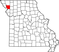 | |
| Villages | ||
| Townships | ||
| Unincorporated communities | ||
| Ghost towns | ||
This article is issued from Wikipedia - version of the 9/3/2016. The text is available under the Creative Commons Attribution/Share Alike but additional terms may apply for the media files.