Jihlava (river)
| Jihlava | |
|---|---|
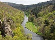 The Jihlava at Lhánice | |
| Country | Czech Republic |
| Basin | |
| Main source | Bohemian-Moravian Highlands |
| River mouth | Svratka |
| Basin size | 2,996.50 km2 (1,156.96 sq mi) |
| Physical characteristics | |
| Length | 180.8 km (112.3 mi) |
| Discharge |
|
The Jihlava (German: Igel) is a river in the Moravia (Czech Republic), the right tributary of the Svratka River. It originates in the Bohemian-Moravian Highlands (Českomoravská vrchovina) upland at the elevation of 665 m and flows for 180.8 km to Nové Mlýny reservoirs, where it enters the Svratka River.
It flows through numerous towns and villages, including Jihlávka, Horní Ves, Horní Cerekev, Batelov, Dolní Cerekev, Kostelec, Dvorce, Rantířov, Jihlava, Malý Beranov, Luka nad Jihlavou, Bítovčice, Bransouze, Číchov, Přibyslavice, Třebíč, Vladislav, Kramolín, Mohelno, Biskoupky, Ivančice, Moravské Bránice, Nové Bránice, Dolní Kounice, Pravlov, Kupařovice, Medlov, Pohořelice, Přibice, Ivaň.
The Dalešice Hydro Power Plant, including the Dalešice and Mohelno Dams, are constructed on the river.
The longest tributaries of the river are the Oslava, Brtnice, Jihlávka and Rokytná.
References
| Wikimedia Commons has media related to Jihlava. |
Coordinates: 48°54′46″N 16°36′18″E / 48.91278°N 16.60500°E