Přibyslavice (Třebíč District)
| Přibyslavice | |||
|---|---|---|---|
| Municipality | |||
|
Přibyslavice | |||
| |||
 Přibyslavice | |||
| Coordinates: 49°15′40″N 15°46′21″E / 49.26111°N 15.77250°ECoordinates: 49°15′40″N 15°46′21″E / 49.26111°N 15.77250°E | |||
| Country |
| ||
| Region | Vysočina | ||
| District | Třebíč | ||
| Area | |||
| • Total | 6.14 km2 (2.37 sq mi) | ||
| Elevation | 427 m (1,401 ft) | ||
| Population (2006) | |||
| • Total | 787 | ||
| • Density | 130/km2 (330/sq mi) | ||
| Postal code | 675 21 | ||
| Website | http://www.pribyslavice.cz | ||
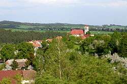


Přibyslavice is a village and municipality (obec) in Třebíč District in the Vysočina Region of the Czech Republic.
The municipality covers an area of 6.14 square kilometres (2.37 sq mi), and has a population of 787 (as at 3 July 2006).
Přibyslavice lies on the Jihlava River, approximately 10 kilometres (6 mi) north-west of Třebíč, 21 km (13 mi) south-east of Jihlava, and 134 km (83 mi) south-east of Prague.
References
| Wikimedia Commons has media related to Přibyslavice (Třebíč District). |
This article is issued from Wikipedia - version of the 4/7/2016. The text is available under the Creative Commons Attribution/Share Alike but additional terms may apply for the media files.