Jim Falls, Wisconsin
| Jim Falls, Wisconsin | |
|---|---|
| Census-designated place | |
 Jim Falls | |
| Coordinates: 45°02′43″N 91°16′23″W / 45.04528°N 91.27306°WCoordinates: 45°02′43″N 91°16′23″W / 45.04528°N 91.27306°W | |
| Country | United States |
| State | Wisconsin |
| County | Chippewa |
| Town | Anson |
| Area | |
| • Total | 0.735 sq mi (1.90 km2) |
| • Land | 0.606 sq mi (1.57 km2) |
| • Water | 0.129 sq mi (0.33 km2) |
| Elevation | 955 ft (291 m) |
| Population (2010) | |
| • Total | 237 |
| • Density | 320/sq mi (120/km2) |
| Time zone | Central (CST) (UTC-6) |
| • Summer (DST) | CDT (UTC-5) |
| ZIP code | 54748 |
| Area code(s) | 715 & 534 |
| GNIS feature ID | 1567178[1] |
| Historical population | |||
|---|---|---|---|
| Census | Pop. | %± | |
| 2010 | 237 | — | |
Jim Falls is an unincorporated census-designated place located in Chippewa County, Wisconsin, United States. Jim Falls is located on the Chippewa River northeast of Chippewa Falls, in the town of Anson. Jim Falls has a post office with ZIP code 54748.[2] As of the 2010 census, its population was 237.[3]
Geography
A stretch of rapids and falls on the Chippewa River provided the focal point around which the town developed. They have been incorporated into a hydroelectric facility operated by Northern States Power Company.[4] However, many geological features of the river bed are visible below the dam.[5]
History
Jim Falls is named in honor of James Ermatinger.[6] In 1840, he established a trading post near the falls, which were then called "Vermillion Falls". Later, he became very involved with public affairs of the village and county. In 1854, he was appointed by the county Board of Supervisors, along with Henry O'Neil, and Daniel McCann, to lay out a road from Chippewa Falls to Vermillion Falls.[7] In 1855, he acted as Justice of the Peace for Chippewa County.
In spring of 1861, the Indian Ahgamahwegezhig captured an eaglet near the South Fork of the Flambeau River, within the present day Chequamegon National Forest, east of Park Falls, Wisconsin. A few weeks later, he canoed down the Chippewa River on a trading expedition. At Jim Falls, he encountered Daniel McCann, to whom he sold the eagle for a bushel of corn.[8] In turn, McCann sold the bird to soldiers of the 8th Wisconsin Volunteer Infantry Regiment. The eagle became their mascot Old Abe, who accompanied them during many battles of the Civil War.[9]
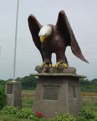
Jim Falls on the Old Abe State Trail.
Because of this connection, the reservoir behind the dam is named "Old Abe Lake." Moreover, in a park on the Old Abe State Trail, which runs through the town, a 10½ foot statue of Old Abe has been erected near the dam.[10]
References
- ↑ U.S. Geological Survey Geographic Names Information System: Jim Falls, Wisconsin
- ↑ ZIP Code Lookup
- ↑ "American FactFinder". U.S. Census Bureau. Retrieved 6 April 2011.
- ↑ "Jim Falls Dam". Energy Justice Network. December 31, 2008. Retrieved 2012-10-30.
- ↑ Dutch, Steven. "Jim Falls". University of Wisconsin - Green Bay. Retrieved 2012-08-19.
- ↑ Barkwell, Lawrence. "James Ermatinger. (1808-1866)". Coordinator of Metis Heritage and History Research, Louis Riel Institute. Scribd Inc. Retrieved 2012-10-26.
- ↑ "Chippewa County Wisconsin History". Chippewa County Wisconsin Genealogy and History. Genealogy Trails. Retrieved 2012-10-22.
- ↑ "How an Indian Chief Captured the Eagle that Became "Old Abe"". Wisconsin in the Civil War. Wisconsin Historical Society. (from the Eau Claire Leader, May 26, 1914. Retrieved 2012-08-15. Check date values in:
|date=(help) - ↑ Barrett, Joseph 0. (1865). History of "Old Abe". Chicago: Dunlop, Sewell & Spalding. Retrieved 2012-08-12.
- ↑ Geist, Dennis. "A Journey Into The Past On The Old Abe Trail". Cornell Area Tourism. Retrieved 2012-10-30.
Municipalities and communities of Chippewa County, Wisconsin, United States | ||
|---|---|---|
| Cities | 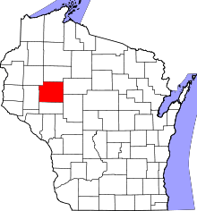 | |
| Villages | ||
| Towns | ||
| CDPs | ||
| Unincorporated communities | ||
| Footnotes | ‡This populated place also has portions in an adjacent county or counties | |
| Core cities |  | ||||||
|---|---|---|---|---|---|---|---|
| Surrounding communities |
| ||||||
| Counties | |||||||