Joes, Colorado
| Joes, Colorado | |
|---|---|
| CDP | |
 Joes, Colorado Location within the state of Colorado | |
| Coordinates: 39°39′21″N 102°40′30″W / 39.65583°N 102.67500°WCoordinates: 39°39′21″N 102°40′30″W / 39.65583°N 102.67500°W | |
| Country |
|
| State |
|
| County | Yuma[1] |
| Elevation[1] | 4,272 ft (1,302 m) |
| Time zone | MST (UTC-7) |
| • Summer (DST) | MDT (UTC-6) |
| ZIP code[2] | 80822 |
| GNIS feature ID | 0204816 |
Joes is a census-designated place and a U.S. Post Office in Yuma County, Colorado, United States. The population as of the 2010 Census was 80.[3] The Joes Post Office has the ZIP Code 80822.[2]
A post office called Joes has been in operation since 1912.[4] The community was named for the fact a share of the first settlers were named Joe.[5]
Geography
Joes is located at 39°39′21″N 102°40′30″W / 39.65583°N 102.67500°W (39.655928,-102.674961).
See also
References
- 1 2 "US Board on Geographic Names". United States Geological Survey. 2007-10-25. Retrieved 2008-01-31.
- 1 2 "ZIP Code Lookup" (JavaScript/HTML). United States Postal Service. December 28, 2006. Retrieved December 28, 2006.
- ↑ Colorado Trend Report 2: State and Complete Places (Sub-state 2010 Census Data). Missouri Census Data Center. Accessed 2011-02-25.
- ↑ "Post offices". Jim Forte Postal History. Retrieved 28 June 2016.
- ↑ Dawson, John Frank. Place names in Colorado: why 700 communities were so named, 150 of Spanish or Indian origin. Denver, CO: The J. Frank Dawson Publishing Co. p. 28.
- Propst, Nell B. (1988). The Boys From Joes: A Colorado Basketball Legend. Boulder, CO: Pruett Publishing. ISBN 0-87108-932-7
Municipalities and communities of Yuma County, Colorado, United States | ||
|---|---|---|
| Cities | 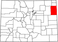 | |
| Town | ||
| CDPs | ||
| Unincorporated communities | ||
This article is issued from Wikipedia - version of the 6/29/2016. The text is available under the Creative Commons Attribution/Share Alike but additional terms may apply for the media files.