John's Burnt Mill Bridge
|
John's Burnt Mill Bridge | |
 | |
  | |
| Location | SW of New Oxford on T 428, Mount Pleasant Township, Pennsylvania |
|---|---|
| Coordinates | 39°49′57″N 77°4′47″W / 39.83250°N 77.07972°WCoordinates: 39°49′57″N 77°4′47″W / 39.83250°N 77.07972°W |
| Area | less than one acre |
| Built | 1800 |
| Architectural style | Other, Camelback |
| NRHP Reference # | 74001731[1] |
| Added to NRHP | December 16, 1974 |
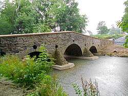
John's Burnt Mill Bridge, also known as Camelback Bridge, is a historic stone arch bridge in Mount Pleasant Township, Adams County, Pennsylvania. It was built between 1800 and 1823, and is a 75-foot-long (23 m), triple-arched fieldstone bridge. The bridge crosses the South Branch Conewago Creek.[2]
It was added to the National Register of Historic Places in 1974.[1]
References
- 1 2 National Park Service (2010-07-09). "National Register Information System". National Register of Historic Places. National Park Service.
- ↑ "National Historic Landmarks & National Register of Historic Places in Pennsylvania" (Searchable database). CRGIS: Cultural Resources Geographic Information System. Note: This includes Charles Dunlevey (July 1973). "National Register of Historic Places Inventory Nomination Form: John's Burnt Mill Bridge" (PDF). Retrieved 2011-12-08.
| Topics |   | |
|---|---|---|
| Lists by county |
| |
| Lists by city | ||
| Other lists | ||
| ||
This article is issued from Wikipedia - version of the 11/26/2016. The text is available under the Creative Commons Attribution/Share Alike but additional terms may apply for the media files.