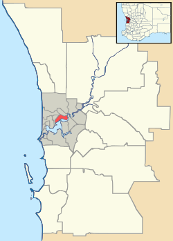
Joondalup (suburb)
| Joondalup Perth, Western Australia | |||||||||||||
|---|---|---|---|---|---|---|---|---|---|---|---|---|---|
 Davidson Terrace, Joondalup | |||||||||||||
 Joondalup | |||||||||||||
| Coordinates | 31°44′42″S 115°45′58″E / 31.745°S 115.766°ECoordinates: 31°44′42″S 115°45′58″E / 31.745°S 115.766°E | ||||||||||||
| Population | 8,420 (2006 census)[1] | ||||||||||||
| • Density | 714/km2 (1,848/sq mi) | ||||||||||||
| Established | 1980s | ||||||||||||
| Postcode(s) | 6027 | ||||||||||||
| Area | 11.8 km2 (4.6 sq mi) | ||||||||||||
| Location | 26 km (16 mi) from Perth | ||||||||||||
| LGA(s) | City of Joondalup | ||||||||||||
| State electorate(s) | Joondalup | ||||||||||||
| Federal Division(s) | Moore | ||||||||||||
| |||||||||||||
Joondalup is a suburb of Perth, Western Australia, which includes the central business district of the regional city of Joondalup, as well as the council chambers for the City of Joondalup local authority.
History
The suburb is named after Lake Joondalup, on the banks of which the suburb resides. The name Joondalup is a Noongar Aboriginal word, first recorded in 1837 and possibly meaning either "place of whiteness or glistening", or "place of a creature that can only move backwards".[2]
Geography
Joondalup is bounded by Burns Beach Road to the north, Mitchell Freeway to the west, Eddystone and Lakeside Drives to the south and Lake Joondalup to the east. Grand Boulevard and Joondalup Drive run through the centre of Joondalup. Most of Joondalup is zoned commercial or residential, although a significant suburban area exists between Moore Drive and Burns Beach Road near Currambine train station, and some small residential estates have been built in recent years along Lakeside Drive. The Yellagonga Regional Park and a small bushland corridor near the TAFE and university campuses can be found in the east and south.[3]
Demographics
At the ABS 2001 census, Joondalup had a population of 6,503 people living in 2,481 dwellings. Joondalup is unusual in that it has the highest proportion of British-born residents in Australia. According to 2001 Census data,[4] 46.7 per cent of the suburb's population were overseas-born, of whom 23.0 per cent (1,613 persons) were born in Britain. This far exceeds the Australian average for both overseas-born and British-born in 2001 — 23.1 per cent and 5.8 per cent respectively.
Nonetheless, the Australia-born still constituted the largest individual birthplace group in Joondalup, at 53.3 per cent (3,730 persons), followed by the British-born at 23.0 per cent (1,613 persons), the New Zealand-born at 3.1 per cent (215 persons) and those born in the Republic of Ireland at 1.3 per cent (94 persons).
Facilities

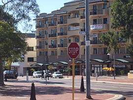
Joondalup's central business district, centred on Grand Boulevard, is largely a shopping and retail area lined with townhouses and apartments. Lakeside Joondalup is located adjacent to the Joondalup railway station and backs onto Grand Boulevard. Originally opened in 1994, it underwent considerable expansion from 2006 onwards, with several new shops and a food court opening on 7 December 2007, and the final stage on 4 December 2008. Also a expansion with a Myer department store opened in November 20 2014 and the final stage opened Early 2015. Reconfiguration of the current centre will result in the inclusion of a further 2 mini-major, a new food court in addition to the current food court and an increase in the floor space of the Coles supermarket. The centre contains branches of the Myer Woolworths, Coles and IGA supermarkets and Target, Kmart and Big W variety and discount stores, as-well as mini majors JB-HiFi Rebel Sport H&M and Best & Less. With one of Western Australia's first ALDI Food Market opening June 2016.
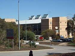
The council chambers for the City of Joondalup are located in Joondalup's central business district. The complex includes Joondalup Library, which serves as the central library and local history centre for both the City of Joondalup and the City of Wanneroo local authorities. The Joondalup Health Campus, the major public hospital for Perth's northern suburbs, a major police station and the Joondalup offices of the Australian Electoral Commission are also located in the CBD.
The city has a number of parks including Central Park and Neil Hawkins Park in the Yellagonga Regional Park. The Neil Hawkins Park is home to many parrots, including the Australian ringneck, cockatoos and kangaroos. The park sits alongside Lake Joondalup and wetlands which stretches out between Burns Beach Road to the north and Ocean Reef Road to the south. These wetlands provide refuge for migratory birds.
Arena Joondalup, located northwest of Lakeside Centre, is the home ground for one of Perth's oldest WAFL clubs, the West Perth Football Club, which moved from West Perth in the 1990s with their latest premiership coming in 2003 over rivals Subiaco. The Arena also hosts music events and festivals during the year, as well as the Home and Lifestyle Expo, an annual exhibition held in late March to early April.
Joondalup is a popular city for nightlife at weekends. The CBD contains two major nightclubs, Crush and Dusk, as well as four pubs around the city; The Old Bailey, the Grand Boulevard Tavern, The Sovereign Arms and Paddy Malone's.
Residential
Most of the residential housing in the city centre consists of either townhouses or apartments. There is a suburban residential area in the north-west corner of Joondalup, bordering the suburb of Currambine. It consists of a few hundred houses, numerous parks and Candlewood Village, a small shopping centre.
Education
Joondalup contains the following educational institutions:
- Joondalup Primary School (opened 1993)
- Lake Joondalup Baptist College (K-12, opened 1990)
- West Coast Institute of Training (TAFE College)
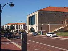
- Edith Cowan University (Joondalup Campus)
- West Australian Institute of Further Studies
- Australian Institute for University Studies (co-located with Curtin University of Technology, Joondalup Campus)
Transport

Joondalup contains two entrances to the Mitchell Freeway on Hodges Drive and Shenton Avenue.
The Joondalup train/bus interchange is located next to Lakeside Joondalup shopping centre. The interchange is connected to the Transperth Train network linking the area to the Perth CBD - a 25-minute journey - and to Butler. For a few months in early 1993, Joondalup was the terminus of the railway, and to this day Transperth still refer to it as the Joondalup Line.
Free CAT buses (routes 10 and 11) travel around Joondalup's central area, ferrying passengers to Joondalup Health Campus, Edith Cowan University, West Coast TAFE and Joondalup CBD among other destinations. The residential part of the suburb to the north is serviced by the 468, 473 and 474 routes. Transperth Trains are operated by the Public Transport Authority, while the buses and CAT services are operated by Path Transit.
References
- ↑ Australian Bureau of Statistics (25 October 2007). "Joondalup (State Suburb)". 2006 Census QuickStats. Retrieved 2008-10-05.
- ↑ Western Australian Land Information Authority. "History of metropolitan suburb names – J". Retrieved 2007-01-17..
- ↑ 2006 StreetSmart Perth street directory, Department of Land Information, Western Australia.
- ↑ 2001 Census, Australian Bureau of Statistics
- ↑ https://www.facebook.com/groups/1755206914719224/1757552304484685/?notif_t=group_activity¬if_id=1475038865145636