Josefův Důl (Jablonec nad Nisou District)
| Josefův Důl | |||
| Josefsthal | |||
| Municipality and village | |||
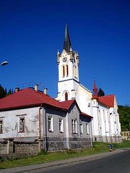 Church in Josefův Důl | |||
|
|||
| Name origin: Joseph's valley,[1] Joseph's Mine[2] | |||
| Motto: The gateway to Jizera Mountains | |||
| Country | Czech Republic | ||
|---|---|---|---|
| Region | Liberec | ||
| District | Jablonec nad Nisou District | ||
| River | Kamenice, Jizera | ||
| Elevation | 625 m (2,051 ft) | ||
| Coordinates | CZ 50°46′44″N 15°14′24″E / 50.779°N 15.240°ECoordinates: CZ 50°46′44″N 15°14′24″E / 50.779°N 15.240°E | ||
| Highest point | |||
| - elevation | 850 m (2,789 ft) | ||
| Lowest point | |||
| - elevation | 600 m (1,969 ft) | ||
| Area | 22 km2 (8 sq mi) | ||
| Population | 1,021 | ||
| First mentioned | 1697 | ||
| Mayor | John Miksa[3] | ||
| Timezone | CET (UTC+1) | ||
| - summer (DST) | CEST (UTC+2) | ||
| Postal code | 468 44 | ||
| Area code | 420-483 | ||
  Location in the Czech Republic | |||
| Statistics: http://www.statnisprava.cz | |||
| Website: http://www.josefuvdul.eu | |||
.svg.png)
_CoA_CZ.jpg)
Josefův Důl (German: Josefsthal) is a village and municipality in the Jablonec nad Nisou District of the Liberec Region in the Czech Republic. The municipality covers an area of 22 square kilometres (8 sq mi) and, as of 2006, it had a population of 1021. It is located at 625 metres (2,051 ft) above sea level in the Valley of the Kamenice river (German: Kamnitz) in the southeastern part of the Jizera Mountains (German: Isergebirge). Above the town 2.5 kilometres (1.6 mi) lies the Kamenice river that is collected by the Josefův Důl dam. Just 8 kilometres (5 mi) south-west sits the town of Jablonec nad Nisou.
History
Beginning in the year 1690, Maximilian II Emanuel populated the area with German immigrants. In 1701, the city of Karlsberg was founded by the Desfours family, who were known for the estates of Groß Rohosetz and Morchenstern. The new village was known for producing glass and crystal products.[4] Karlsberg was divided into Untermaxdorf, Karlsberg and Josefsthal in 1827. Fifty years later Untermaxdorf and Antoniwald were incorporated.
The Munich Agreement permitted Nazi Germany's Adolf Hitler to annex the area in 1938 into what he called the Sudetenland. Shortly thereafter Karlsberg was dissolved becoming Obermaxdorf and Antoniwald. Josefsthal and Untermaxdorf formed a new community named Iserwald. Following World War II, in 1945, the town returned to Czechoslovakia and the German inhabitants were expelled under the terms of Beneš decrees.
The Church
The Josefův Důl church was built between 1862 and 1865 in a neo-gothic style. Its construction was partially funded by a lottery and 4000 gold pieces were collected. The ceremonial laying of the foundation stone was held in September 1862. The church tower is 45 metres (148 ft) high, the interior fittings house three valuable altar paintings by Wilhelm Kandler.[5]

Present day
Known as "the gateway to Jizera Mountains" it is a popular destination for skiers, hikers and cyclists. Rivers in the town include the Kamenice, which is a tributary of the Jizera river, and the Jedlová river which flows through the Jedlový dul nature reserve.[4]
Landmarks
- Neo-Gothic church from 1862
- Castle, seat of the royal family of the Des Fours-Walderode
Neighbouring communities
The municipality of Josefův Důl includes the villages of Ortsteile Antonínov (Antoniwald), Karlov (Karlsberg) and Dolní Maxov (Untermaxdorf).
List of people from Josefův Důl
- Gustav Leutelt (1860–1947), poet, writer
- Fidelio F. Finke (1891–1968), composer
- Anna Fatton-Janoušková (~1965), cross-country skier
References
- ↑ http://dict.leo.org/ende?lp=ende&p=30lVUi8AA&search=Tal&trestr=0x2801
- ↑ http://translate.google.ca/translate_t?q=Josef%C5%AFv%20D%C5%AFl&oe=utf-8&rls=org.mozilla:en-US:official&client=firefox-a&um=1&ie=UTF-8&sa=N&hl=en&tab=wT#
- ↑ http://josefuvdul.eu/obecni-urad/
- 1 2 http://josefuvdul.eu/
- ↑ farní kronika z let 1865 - 1947, uložena v okresním archivu v Jablonci nad Nisou