June 1966 tornado outbreak sequence
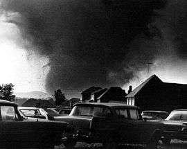 A photograph of the F5 Topeka, Kansas tornado. | |
| Type | Tornado outbreak |
|---|---|
| Duration | June 3–12 |
| Tornadoes confirmed | 57 |
| Max rating1 | F5 tornado |
| Duration of tornado outbreak2 | ~11 days |
| Damage |
$250.603 million (1966 USD) $694.79 million (2008 USD) |
| Casualties | 18 fatalities, 543 injuries |
| Areas affected | Southern and Midwestern United States, Great Plains |
|
1Most severe tornado damage; see Fujita scale 2Time from first tornado to last tornado | |
The June 1966 tornado outbreak sequence[nb 1][nb 2] was a series of tornado outbreaks which occurred between June 2 and June 12.
The most destructive tornado of this event occurred on the early evening of June 8, 1966, when Topeka, Kansas was struck by an F5 rated tornado. It started on the southwest side of town, moving northeast, passing through several subdivisions and over a local landmark named Burnett's Mound. 57 tornadoes were confirmed during the 11-day span, which left 18 people dead and 543 injured.
Topeka, Kansas tornado
According to a local Native American legend, Burnet's Mound (a local landmark that was named after Potawatomi Indian chief Abram Burnett, and also believed to be an ancient Native American burial ground) was thought to protect the city from tornadoes, suggesting that the 250 feet (76 m) hill would cause a tornado that was approaching Topeka to disintegrate. A few years earlier, a water tower had been built directly on the mound, which sparked controversy among many Topeka residents as they felt it would negatively affect the mound's ability to keep the city safe from tornadic activity. However, ten other tornadoes had struck the city since Kansas state tornado records were first kept in 1889. The 1966 tornado was significantly stronger than the other ten tornadoes that struck Topeka prior to June 8.[2]
The Topeka tornado began developing at 6:55 p.m. Central Time on June 8, touching down 8 miles (13 km) west of the city. The National Weather Service could not detect the developing tornado on radar as the Topeka forecast office used a modified military radar that was donated by the U.S. government following World War II. While it was considered state-of-the-art for its time, it had a limited ability to detect tornadic activity, compared to the Doppler weather radar of the present day. Around 7:30 p.m., a 1/4 to 1/2-mile (400–800 m) wide tornado tracked into the southwest side of town, moving northeast, and passed over Burnett's Mound. Bill Kurtis, then a reporter for WIBW-TV (channel 13; then a hybrid CBS/ABC/NBC affiliate, now only affiliated with CBS) wanted to get people the message to take shelter from the devastating storm, ultimately advising viewers to get to safety by urging in a calm but stern manner, "for God's sake, take cover!"

After broadcasting a take-cover report on the air while driving down the winding road on Burnett's Mound with the tornado approaching his direction, Rick Douglass, a reporter for radio station WREN (1250 AM, now KYYS), attempted to take shelter under an overpass, while trying to do a second live report on the storm. Douglass was carried by the tornado, becoming airborne for a few seconds, and was dropped over one block away. Douglass, whose clothes were ripped from his body, was pushed by the strong winds along the ground until the tornado passed on to make a six-block swath across Topeka. Douglas was found with dirt and debris covering his body. When he arrived at an area hospital, a nurse placed a cover over Douglas's face – believing he had perished; in an interview with The History Channel's Wrath of God, Douglass stated that he then pulled off the cover, resulting in the attending nurse wincing in reaction; Douglass found shards of debris in his skin for several years after the tornado and was left with a smell he described in the interview as "a mix of blood, guts, wood and metal" for several weeks.

The tornado first struck residential areas, cleanly sweeping away entire rows of homes and hurling vehicles hundreds of yards through the air. Grass was scoured from the ground as well, according to eyewitnesses.[3] Washburn University took a direct hit from the tornado, and many of the large stone buildings on campus were badly damaged or destroyed.[3] A 300-pound section of stone wall was torn from one building and thrown two miles away.[4] One vehicle on campus was reportedly lofted and thrown over the top of the university's ROTC building, before coming to rest on the 50-yard line of the football field.[5] The tornado went on to rip through the central part of the city, hitting the downtown area. Buses were crushed as the transportation barn was collapsed by the tornado and the trains on the Santa Fe Railway were overturned. Most of the downtown buildings were badly damaged or had their windows blown out. Cars were flipped and tossed, and streets were blocked with debris. Many workers at the AT&T building downtown took shelter after a co-worker notified people of the approaching tornado, which they could not hear through the soundproof operating room. The building was hit, but only light damage occurred. The Kansas State Capitol building also experienced minor damage.
Ironically as the storm raged on past the downtown area, meteorologists at the National Weather Service Topeka forecast office (located at Philip Billard Municipal Airport) had to take shelter as well, as the tornado tracked through the airport, flipping over several airplanes. At 7:29 p.m., 34 minutes after it touched down, the tornado dissipated after ripping through the airport; by this point, the tornado had traversed 22 miles (35 km) of the city, with a damage path width of 1/2 mile (800 m). The most intense damage occurred in residential areas on the east side of town, partly due to the close proximity of housing units. Homes and other buildings along the tornado's path were completely obliterated, and the National Weather Service Topeka forecast office years later rated this tornado as an F5 on the Fujita scale.
Then-mayor Chuck Wright later issued a decree that those caught looting would be shot on sight. The Kansas National Guard was called in to handle the situation. Streets in devastated areas of the city were filled with sightseers checking out the ruins of homes and businesses, hampering efforts from first responders to find those missing under rubble. Families of victims also came onto the scene to try to find those missing.
The total damage estimate was put at $250 million (US$ 731 million in 2016) making it one of the costliest tornadoes in U.S. history. Even to this day, with inflation factored in, the Topeka tornado stands as the seventh costliest tornado on record. 820 homes were destroyed and 3,000 others were damaged. 250 businesses were destroyed and 2,390 were damaged including a major shopping center. 330 of the damaged homes and businesses suffered major damage and the other 5,000 received lesser degrees of damage. Hundreds of apartments were destroyed. Many government buildings, public buildings, other structures and much other property were damaged or destroyed.
Overall, 16 people were killed, and many others were injured. However, it is believed that had the tornado hit during school and work hours or during the night, that as many as 5,000 people would have been killed. Bill Kurtis was credited for saving many lives with his urgent message to take cover.
Casualties
| State | Total | County | County total |
|---|---|---|---|
| Kansas | 17 | Leavenworth | 1 |
| Shawnee | 16 | ||
| Illinois | 1 | Cook | 1 |
| Totals | 18 | ||
| All deaths were tornado-related | |||
Confirmed tornadoes
- 5 Tornadoes were confirmed but were not given an F-Scale intensity.
| F0 | F1 | F2 | F3 | F4 | F5 | Total |
|---|---|---|---|---|---|---|
| 12 | 17 | 18 | 2 | 2 | 1 | 57 |
June 3 event
| List of reported tornadoes - Friday, June 3, 1966 | ||||||
|---|---|---|---|---|---|---|
| | | | | | ||
| South Dakota | ||||||
| F? | Aurora | 43°54′N 98°54′W / 43.9°N 98.9°W | 2300 | 0.1 miles (0.2 km) | Brief touchdown, no damage reported. Tornado was confirmed but was not given a rating. | |
| F0 | Yankton | 42°54′N 97°24′W / 42.9°N 97.4°W | 0200 | 0.1 miles (0.2 km) | Brief touchdown, no damage reported. | |
| Sources:
,[6] | ||||||
June 4 event
| List of reported tornadoes - Saturday, June 4, 1966 | |||||
|---|---|---|---|---|---|
| | | | | | |
| Colorado | |||||
| F0 | Logan | 40°56′N 103°11′W / 40.93°N 103.18°W | 2300 | 0.1 miles (0.2 km) | Brief touchdown, no damage reported. |
| Wisconsin | |||||
| F2 | Oconto | 45°01′N 88°23′W / 45.02°N 88.38°W | 0100 | 5.4 miles (8.7 km) | First of the F2 triplet tornadoes in Oconto County. Barns were destroyed. |
| F2 | Oconto | 44°57′N 88°20′W / 44.95°N 88.33°W | 0100 | 4.9 miles (7.9 km) | Second of the F2 triplet tornadoes in Oconto County. |
| F2 | Oconto | 44°53′N 88°18′W / 44.88°N 88.3°W | 0100 | 4.7 miles (7.6 km) | Last of the F2 triplet tornadoes in Oconto County. |
| Nebraska | |||||
| F? | Morrill | 41°44′N 102°52′W / 41.73°N 102.87°W | 0148 | 0.1 miles (0.2 km) | Brief touchdown, no damage reported. |
| South Dakota | |||||
| F2 | Gregory | 43°14′N 99°26′W / 43.23°N 99.43°W | 330 | 1 mile (1.6 km) | 1.5 mile wide tornado caused severe damage. |
June 5 event
| List of reported tornadoes - Sunday, June 5, 1966 | |||||
|---|---|---|---|---|---|
| | | | | | |
| Nebraska | |||||
| F2 | Boone | 41°42′N 98°10′W / 41.7°N 98.17°W | 0608 | 0.7 miles (1.1 km) | 1 Injury Brief touchdown injured one person. |
| F? | Madison | 41°00′N 97°36′W / 41°N 97.6°W | 0612 | 0.1 miles (0.2 km) | Brief touchdown, no damage reported. Tornado was confirmed but was not given an F-Scale intensity. |
| Minnesota | |||||
| F0 | Pipestone | 43°58′N 96°05′W / 43.97°N 96.08°W | 1200 | 0.1 miles (0.2 km) | Brief touchdown caused minor damage. |
| Oklahoma | |||||
| F0 | Baine | 35°51′N 98°28′W / 35.85°N 98.47°W | 2300 | 0.1 miles (0.2 km) | Brief touchdown, no damage reported. |
| F2 | Kay | 36°50′N 97°24′W / 36.83°N 97.4°W | 2350 | 2.5 miles (4.0 km) | 1 Injury A house was pushed 12 feet off of its foundation and another was badly damaged. Barns were destroyed as well. |
| F0 | Garfield | 36°29′N 97°53′W / 36.48°N 97.88°W | 0030 | 4.3 miles (6.9 km) | No damage reported. First of four tornadoes to hit Garfield County in only 30 minutes. |
| F1 | Grant | 36°40′N 97°37′W / 36.67°N 97.62°W | 0030 | 1.4 miles (2.3 km) | Quarter-mile-wide tornado caused damage to structures. |
| F2 | Garfield | 36°28′N 97°53′W / 36.47°N 97.88°W | 0035 | 0.1 miles (0.2 km) | 6 Injuries Tornado struck Enid and caused $250,000 in damages. 3 trailers were destroyed and 3 others were damaged. 11 homes had their roofs torn off and 112 others were damaged. Boxcars were overturned and a truck garage was destroyed. Second of four tornadoes to hit Garfield County in only 30 minutes. |
| F0 | Garfield | 36°18′N 98°06′W / 36.3°N 98.1°W | 0055 | 3.8 miles (6.1 km) | Third of four tornadoes to hit Garfield County in only 30 minutes. |
| F1 | Garfield | 36°22′N 97°54′W / 36.37°N 97.9°W | 0100 | 5.7 miles (9.2 km) | Last of four tornadoes to hit Garfield County in only 30 minutes. |
| Missouri | |||||
| F1 | Gentry | 40°14′N 94°17′W / 40.23°N 94.28°W | 0000 | 0.1 miles (0.2 km) | Brief touchdown caused minor damage. |
| Iowa | |||||
| F2 | Linn | 42°17′N 91°30′W / 42.28°N 91.5°W | 0430 | 0.1 miles (0.2 km) | |
June 6 event
| List of reported tornadoes - Monday, June 6, 1966 | |||||
|---|---|---|---|---|---|
| | | | | | |
| Kentucky | |||||
| F2 | McCracken, Madison | 36°58′N 88°37′W / 36.97°N 88.62°W | 1800 | 18.5 miles (29.8 km) | 2 Injuries Long track tornado injured 2 people. |
| Florida | |||||
| F1 | Pinellas | 27°55′N 82°45′W / 27.92°N 82.75°W | 2030 | 0.3 miles (0.5 km) | 1 Injury Brief touchdown. |
June 7 event
| List of reported tornadoes - Tuesday, June 7, 1966 | |||||
|---|---|---|---|---|---|
| | | | | | |
| Kansas | |||||
| F? | Wallace | 38°51′N 101°42′W / 38.85°N 101.7°W | 2310 | 0.1 miles (0.2 km) | Brief touchdown, no damage reported. Tornado was confirmed but was not given an F-Scale intensity. |
| F0 | McPherson | 38°12′N 97°31′W / 38.2°N 97.52°W | 2330 | 0.1 miles (0.2 km) | Brief touchdown caused minor damage. |
| F? | Ellis | 38°47′N 99°29′W / 38.78°N 99.48°W | 0100 | 0.1 miles (0.2 km) | Brief touchdown caused minor damage. Tornado was confirmed but was not given an F-Scale intensity. |
| Missouri | |||||
| F0 | Stoddard | 37°06′N 89°55′W / 37.1°N 89.92°W | 2330 | 0.1 miles (0.2 km) | Brief touchdown caused minor damage. |
| Oklahoma | |||||
| F0 | Ellis | 37°06′N 89°55′W / 37.1°N 89.92°W | 0000 | 0.1 miles (0.2 km) | Brief touchdown, no damage reported. |
June 8 event
| List of reported tornadoes - Wednesday, June 8, 1966 | |||||
|---|---|---|---|---|---|
| | | | | | |
| Florida | |||||
| F0 | Miami-Dade | 25°45′N 80°15′W / 25.75°N 80.25°W | 1200 | 4.9 miles (7.9 km) | No damage reported. |
| F1 | Miami-Dade | 25°36′N 80°18′W / 25.6°N 80.3°W | 1700 | 0.1 miles (0.2 km) | Brief touchdown caused minor damage. |
| Kansas | |||||
| F0 | Rice | 38°15′N 98°24′W / 38.25°N 98.4°W | 2118 | 0.1 miles (0.2 km) | Brief touchdown, no damage reported. |
| F2 | Clay | 39°08′N 97°09′W / 39.13°N 97.15°W | 2337 | 8.9 miles (14.3 km) | Caused damage to farms. |
| F3 | Riley | 39°04′N 96°46′W / 39.07°N 96.77°W | 0000 | 13.8 miles (22.2 km) | At least 65 Injuries. Enormous 1.2 mile wide tornado, caused $5 million in damage in Manhattan. KSU campus sustained $1,850,000 in damage alone. 11 homes were destroyed and others were unroofed. An apartment building and 66 trailers were destroyed as well.[7] |
| F5 | Shawnee | 38°55′N 95°55′W / 38.92°N 95.92°W | 0100 | 21.1 miles (34.0 km) | 16 Deaths 450 Injuries. See section on this tornado |
| F2 | Leavenworth | 39°14′N 95°02′W / 39.23°N 95.03°W | 0115 | 8.2 miles (13.2 km) | Trailers were destroyed and a home was unroofed. First of two tornadoes to hit Leavenworth County. |
| F4 | Leavenworth | 39°10′N 95°11′W / 39.17°N 95.18°W | 0200 | 19.9 miles (32.0 km) | 1 Death 2 Injuries. One home was leveled and a car was thrown and destroyed. Second of two tornadoes to hit Leavenworth County. |
| Oklahoma | |||||
| F1 | Caddo | 35°29′N 98°24′W / 35.48°N 98.4°W | 2330 | 0.5 miles (0.8 km) | Brief touchdown caused minor damage. |
| F0 | Washita | 35°18′N 98°48′W / 35.3°N 98.8°W | 0000 | 0.1 miles (0.2 km) | Brief touchdown, no damage reported. |
| F0 | Caddo | 35°10′N 98°12′W / 35.17°N 98.2°W | 0120 | 0.1 miles (0.2 km) | Brief touchdown, no damage reported. |
June 9 event
| List of reported tornadoes - Thursday, June 9, 1966 | |||||
|---|---|---|---|---|---|
| | | | | | |
| Illinois | |||||
| F0 | Cook | 42°06′N 88°01′W / 42.1°N 88.02°W | 1110 | 0.1 miles (0.2 km) | Brief touchdown, no damage reported. |
| F2 | Cook | 42°06′N 88°01′W / 42.1°N 88.02°W | 1115 | 0.1 miles (0.2 km) | Brief touchdown. |
| F2 | Cook | 42°06′N 87°56′W / 42.1°N 87.93°W | 1120 | 2.5 miles (4.0 km) | 1 Death 30 Injuries Tornado unroofed homes and apartment buildings in the area. A trailer was destroyed as well. |
| Florida | |||||
| F1 | Jackson | 30°48′N 85°14′W / 30.8°N 85.23°W | 1200 | 0.1 miles (0.2 km) | Brief touchdown caused minor damage. |
| F? | Jackson | 30°48′N 85°14′W / 30.8°N 85.23°W | 1605 | 0.1 miles (0.2 km) | Brief touchdown, no damage reported. Tornado was confirmed but was not given an F-Scale intensity. |
| Michigan | |||||
| F2 | Barry | 42°15′N 85°23′W / 42.25°N 85.38°W | 1400 | 2 miles (3.2 km) | Tornado caused moderate damage in the area. |
| New York | |||||
| F0 | Erie | 42°38′N 78°33′W / 42.63°N 78.55°W | 2200 | 1 mile (1.6 km) | Brief touchdown caused minor damage. |
June 10 event
| List of reported tornadoes - Friday, June 10, 1966 | |||||
|---|---|---|---|---|---|
| | | | | | |
| Texas | |||||
| F2 | Swisher | 34°21′N 101°44′W / 34.35°N 101.73°W | 0130 | 36.9 miles (59.4 km) | Long track tornado. |
| F1 | Swisher | 34°21′N 101°44′W / 34.35°N 101.73°W | 0130 | 2 miles (3.2 km) | Brief touchdown, no damage reported. |
| F0 | Swisher | 34°39′N 101°30′W / 34.65°N 101.5°W | 0130 | 2 miles (3.2 km) | Brief touchdown, no damage reported. |
June 11 event
| List of reported tornadoes - Saturday, June 11, 1966 | |||||
|---|---|---|---|---|---|
| | | | | | |
| Minnesota | |||||
| F1 | Minnesota | 47°11′N 95°55′W / 47.18°N 95.92°W | 2115 | 1.9 miles (3.1 km) | Brief touchdown caused minor damage. |
| F4 | Crow Wing, Cass | 46°38′N 94°22′W / 46.63°N 94.37°W | 2300 | 72.8 miles (117.2 km) | Very long track half-mile-wide tornado completely leveled several farms, and damaged at least 20 others. Two homes sustained near F5-damage with only clean slabs remaining. Thousands of trees were snapped and 3 people were injured. |
| Iowa | |||||
| F2 | Polk | 41°34′N 93°33′W / 41.57°N 93.55°W | 2345 | 12.2 miles (19.6 km) | |
| F2 | Mitchell | 43°23′N 92°54′W / 43.38°N 92.9°W | 0100 | 1 mile (1.6 km) | |
| F1 | Marshall | 41°50′N 92°58′W / 41.83°N 92.97°W | 0145 | 0.1 miles (0.2 km) | Brief touchdown caused minor damage. |
| F2 | Boone | 42°05′N 93°52′W / 42.08°N 93.87°W | 0230 | 2 miles (3.2 km) | |
| F1 | Story | 42°12′N 93°24′W / 42.2°N 93.4°W | 0300 | 2 miles (3.2 km) | Brief touchdown caused minor damage. |
June 12 event
| List of reported tornadoes - Sunday, June 12, 1966 | |||||
|---|---|---|---|---|---|
| | | | | | |
| Kansas | |||||
| F1 | Douglas | 39°03′N 95°27′W / 39.05°N 95.45°W | 2201 | 0.1 miles (0.2 km) | Brief touchdown caused minor damage. |
| Missouri | |||||
| F0 | Clay | 39°18′N 94°31′W / 39.3°N 94.52°W | 2245 | 0.1 miles (0.2 km) | Brief touchdown, no damage reported. |
| F1 | Monroe | 39°31′N 92°10′W / 39.52°N 92.17°W | 2330 | 0.2 miles (0.3 km) | Brief touchdown caused minor damage. |
| Texas | |||||
| F3 | Denton | 33°18′N 97°00′W / 33.3°N 97.0°W | 0045 | 3.6 miles (5.8 km) | |
See also
References
- ↑ Schneider, Russell S.; Harold E. Brooks; Joseph T. Schaefer. "Tornado Outbreak Day Sequences: Historic Events and Climatology (1875-2003)" (PDF). Norman, Oklahoma: Storm Prediction Center. Retrieved 13 February 2013.
- ↑ Archived November 14, 2005, at the Wayback Machine.
- 1 2 "Stories of the 1966 Topeka Tornado". Washburn.edu. Washburn University. Retrieved December 23, 2013.
- ↑ extremeplanet (2013-03-11). "Analysis of Violent Tornadoes that have Struck Downtown Areas |". Extremeplanet.me. Retrieved 2013-09-09.
- ↑ "Washburn university Devastation and Recovery". Washburn.edu. Washburn University. Retrieved December 23, 2013.
- ↑ Archived May 3, 2008, at the Wayback Machine.
- ↑ "City Officials set Damage at $5 Million". Topeka Capital-Journal. 1966-06-10. Retrieved 2008-08-13.
Notes
- ↑ An outbreak is generally defined as a group of at least six tornadoes (the number sometimes varies slightly according to local climatology) with no more than a six-hour gap between individual tornadoes. An outbreak sequence, prior to (after) modern records that began in 1950, is defined as, at most, two (one) consecutive days without at least one significant (F2 or stronger) tornado.[1]
- ↑ All damage totals are in 1966 United States dollars unless otherwise noted.
External links
- Tornado Damage Patterns in Topeka, Kansas, June 8, 1966 (Monthly Weather Review, Vol. 95, No. 6)
- NWS Topeka page
- Topeka Capital-Journal online
- Access Menninger photographs and documents on Kansas Memory, the Kansas State Historical Society's digital portal
- The Topeka Tornado of 1966: Never Before Published Damage Photos
| 10 costliest US tornadoes | ||||
|---|---|---|---|---|
| Rank | Area affected | Date | Damage 1 | Adjusted Damage 2 |
| 1 | Joplin, Missouri | May 22, 2011 | 2800 | 2950 |
| 2 | Tuscaloosa, Alabama | April 27, 2011 | 2450 | 2582 |
| 3 | Moore, Oklahoma | May 20, 2013 | 2000 | 2035 |
| 4 | Oklahoma City Metro, Oklahoma | May 3, 1999 | 1000 | 1422 |
| 5 | Hackleburg, Alabama | April 27, 2011 | 1290 | 1359 |
| 6 | Wichita Falls, Texas | April 10, 1979 | 400 | 1305 |
| 7 | Omaha, Nebraska | May 6, 1975 | 250 | 1100 |
| 8 | Washington, Illinois | November 17, 2013 | 935 | 951 |
| 9 | Lubbock, Texas | May 11, 1970 | 250 | 824 |
| 10 | Topeka, Kansas | June 8, 1966 | 250 | 729 |
| Source: Brooks, Harold E.; C. A. Doswell (Feb 2001). "Normalized Damage from Major Tornadoes in the United States: 1890–1999". Weather and Forecasting. American Meteorological Society. 16 (1): 168–76. doi:10.1175/1520-0434(2001)016<0168:NDFMTI>2.0.CO;2. 3 | ||||
|
1. These are the unadjusted damage totals in millions of US dollars. | ||||