Clay County, Kansas
| Clay County, Kansas | |
|---|---|
| County | |
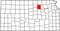 Location in the U.S. state of Kansas | |
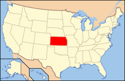 Kansas's location in the U.S. | |
| Founded | February 20, 1857 |
| Named for | Henry Clay |
| Seat | Clay Center |
| Largest city | Clay Center |
| Area | |
| • Total | 656 sq mi (1,699 km2) |
| • Land | 645 sq mi (1,671 km2) |
| • Water | 10 sq mi (26 km2), 1.6% |
| Population | |
| • (2010) | 8,535 |
| • Density | 13/sq mi (5/km²) |
| Congressional district | 1st |
| Time zone | Central: UTC-6/-5 |
| Website |
ClayCountyKansas |
Coordinates: 39°21′N 97°10′W / 39.350°N 97.167°W
Clay County (county code CY) is a county located in the U.S. state of Kansas. As of the 2010 census, the county population was 8,535.[1] Its county seat and most populous city is Clay Center.[2]
History
Early history
For many millennia, the Great Plains of North America was inhabited by nomadic Native Americans. From the 16th century to 18th century, the Kingdom of France claimed ownership of large parts of North America. In 1762, after the French and Indian War, France secretly ceded New France to Spain, per the Treaty of Fontainebleau.
19th century
In 1802, Spain returned most of the land to France, but keeping title to about 7,500 square miles. In 1803, most of the land for modern day Kansas was acquired by the United States from France as part of the 828,000 square mile Louisiana Purchase for 2.83 cents per acre.
In 1854, the Kansas Territory was organized, then in 1861 Kansas became the 34th U.S. state. In 1857, Clay County was established.
When the first counties were created by the Kansas legislature in 1855, the territory within the present limits of the county was attached to Riley County for all revenue and judicial purposes. Subsequently Clay was attached to Geary County. In 1857, Clay was created and named in honor of the famous American statesman Henry Clay,[3] a member of the United States Senate from Kentucky and United States Secretary of State in the 19th century.
In 1887, the Atchison, Topeka and Santa Fe Railway built a branch line from Neva (3 miles west of Strong City) to Superior, Nebraska. This branch line connected Strong City, Neva, Rockland, Diamond Springs, Burdick, Lost Springs, Jacobs, Hope, Navarre, Enterprise, Abilene, Talmage, Manchester, Longford, Oak Hill, Miltonvale, Aurora, Huscher, Concordia, Kackley, Courtland, Webber, Superior. At some point, the line from Neva to Lost Springs was pulled but the right of way has not been abandoned. This branch line was originally called "Strong City and Superior line" but later the name was shortened to the "Strong City line". In 1996, the Atchison, Topeka and Santa Fe Railway merged with Burlington Northern Railroad and renamed to the current BNSF Railway. Most locals still refer to this railroad as the "Santa Fe".
21st century
In 2010, the Keystone-Cushing Pipeline (Phase II) was constructed north to south through Clay County, with much controversy over tax exemption and environmental concerns (if a leak ever occurs).[4][5] A pumping station named Riley was built along the pipeline.
Geography
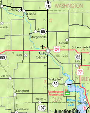
According to the U.S. Census Bureau, the county has a total area of 656 square miles (1,700 km2), of which 645 square miles (1,670 km2) is land and 10 square miles (26 km2) (1.6%) is water.[6]
Adjacent counties
- Washington County (north)
- Riley County (east)
- Geary County (southeast)
- Dickinson County (south)
- Ottawa County (southwest)
- Cloud County (west)
Major highways
Sources: National Atlas,[7] U.S. Census Bureau[8]
Demographics
| Historical population | |||
|---|---|---|---|
| Census | Pop. | %± | |
| 1860 | 163 | — | |
| 1870 | 2,942 | 1,704.9% | |
| 1880 | 12,320 | 318.8% | |
| 1890 | 16,146 | 31.1% | |
| 1900 | 15,833 | −1.9% | |
| 1910 | 15,251 | −3.7% | |
| 1920 | 14,365 | −5.8% | |
| 1930 | 14,556 | 1.3% | |
| 1940 | 13,281 | −8.8% | |
| 1950 | 11,697 | −11.9% | |
| 1960 | 10,675 | −8.7% | |
| 1970 | 9,890 | −7.4% | |
| 1980 | 9,802 | −0.9% | |
| 1990 | 9,158 | −6.6% | |
| 2000 | 8,822 | −3.7% | |
| 2010 | 8,535 | −3.3% | |
| Est. 2015 | 8,347 | [9] | −2.2% |
| U.S. Decennial Census[10] 1790-1960[11] 1900-1990[12] 1990-2000[13] 2010-2013[1] | |||
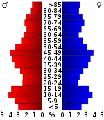
As of the U.S. Census in 2000,[14] there were 8,822 people, 3,617 households, and 2,517 families residing in the county. The population density was 14 people per square mile (5/km²). There were 4,084 housing units at an average density of 6 per square mile (2/km²). The racial makeup of the county was 97.72% White, 0.57% Black or African American, 0.41% Native American, 0.15% Asian, 0.26% from other races, and 0.90% from two or more races. Hispanic or Latino of any race were 0.83% of the population.
There were 3,617 households out of which 30.50% had children under the age of 18 living with them, 59.90% were married couples living together, 6.10% had a female householder with no husband present, and 30.40% were non-families. 27.70% of all households were made up of individuals and 15.40% had someone living alone who was 65 years of age or older. The average household size was 2.39 and the average family size was 2.91.
In the county the population was spread out with 24.90% under the age of 18, 6.70% from 18 to 24, 23.90% from 25 to 44, 23.70% from 45 to 64, and 20.80% who were 65 years of age or older. The median age was 41 years. For every 100 females there were 99.10 males. For every 100 females age 18 and over, there were 95.60 males.
The median income for a household in the county was $33,965, and the median income for a family was $41,103. Males had a median income of $28,817 versus $17,760 for females. The per capita income for the county was $17,939. About 6.80% of families and 10.10% of the population were below the poverty line, including 14.60% of those under age 18 and 8.60% of those age 65 or over.
Law and government
Although the Kansas Constitution was amended in 1986 to allow the sale of alcoholic liquor by the individual drink with the approval of voters, Clay County has remained a prohibition, or "dry", county.[15]
Education
Unified school districts
- Clay County USD 379, located in Clay Center
Communities
Cities
- Clay Center
- Wakefield
- Clifton (partly in Washington County)
- Morganville
- Green
- Longford
- Vining (partly in Washington County)
- Oak Hill
Unincorporated communities
Townships
Clay County is divided into eighteen townships. The city of Clay Center is considered governmentally independent and is excluded from the census figures for the townships. In the following table, the population center is the largest city (or cities) included in that township's population total, if it is of a significant size.
Notable people
Two former Kansas Governors resided in Clay County. George Docking was the 35th Governor, serving from January 14, 1957 until January 9, 1961.[16] William H. Avery was the 37th Governor, from January 11, 1965 until January 9, 1967.[17]
See also
|
|
References
- 1 2 "State & County QuickFacts". United States Census Bureau. Retrieved July 22, 2014.
- ↑ "Find a County". National Association of Counties. Archived from the original on 2011-05-31. Retrieved 2011-06-07.
- ↑ Gannett, Henry (1905). The Origin of Certain Place Names in the United States. Govt. Print. Off. p. 83.
- ↑ Keystone Pipeline - Marion County Commission calls out Legislative Leadership on Pipeline Deal; April 18, 2010. Archived October 22, 2011, at the Wayback Machine.
- ↑ Keystone Pipeline - TransCanada inspecting pipeline; December 10, 2010.
- ↑ "US Gazetteer files: 2010, 2000, and 1990". United States Census Bureau. 2011-02-12. Retrieved 2011-04-23.
- ↑ National Atlas Archived December 5, 2008, at the Wayback Machine.
- ↑ U.S. Census Bureau TIGER shape files
- ↑ "County Totals Dataset: Population, Population Change and Estimated Components of Population Change: April 1, 2010 to July 1, 2015". Retrieved July 2, 2016.
- ↑ "U.S. Decennial Census". United States Census Bureau. Archived from the original on May 11, 2015. Retrieved July 22, 2014.
- ↑ "Historical Census Browser". University of Virginia Library. Retrieved July 22, 2014.
- ↑ "Population of Counties by Decennial Census: 1900 to 1990". United States Census Bureau. Retrieved July 22, 2014.
- ↑ "Census 2000 PHC-T-4. Ranking Tables for Counties: 1990 and 2000" (PDF). United States Census Bureau. Retrieved July 22, 2014.
- ↑ "American FactFinder". United States Census Bureau. Archived from the original on 2013-09-11. Retrieved 2008-01-31.
- ↑ "Map of Wet and Dry Counties". Alcoholic Beverage Control, Kansas Department of Revenue. November 2004. Archived from the original on 2007-10-08. Retrieved 2007-01-21.
- ↑ "To Seek Third Term". The Fort Scott Tribune. May 2, 1970. Retrieved March 30, 2012.
- ↑ "Former Kan. Gov. Avery dies at the age of 98". Associated Press. November 5, 2009.
Further reading
- History of the State of Kansas; William G. Cutler; A.T. Andreas Publisher; 1883. (Online HTML eBook)
- Kansas : A Cyclopedia of State History, Embracing Events, Institutions, Industries, Counties, Cities, Towns, Prominent Persons, Etc; 3 Volumes; Frank W. Blackmar; Standard Publishing Co; 944 / 955 / 824 pages; 1912. (Volume1 - Download 54MB PDF eBook),(Volume2 - Download 53MB PDF eBook), (Volume3 - Download 33MB PDF eBook)
External links
| Wikimedia Commons has media related to Clay County, Kansas. |
- County
- Historical
- Maps
- Clay County Maps: Current, Historic, KDOT
- Kansas Highway Maps: Current, Historic, KDOT
- Kansas Railroad Maps: Current, 1996, 1915, KDOT and Kansas Historical Society
 |
Washington County | | ||
| Cloud County | |
Riley County | ||
| ||||
| | ||||
| Ottawa County | Dickinson County | Geary County |
Municipalities and communities of Clay County, Kansas, United States | ||
|---|---|---|
| Cities | | |
| Unincorporated communities | ||
| Townships | ||
| Footnotes | ‡This populated place also has portions in an adjacent county or counties | |