Kagarko
| Kagarko | |
|---|---|
| LGA and town | |
 Kagarko Location in Nigeria | |
| Coordinates: 9°27′0″N 7°41′0″E / 9.45000°N 7.68333°ECoordinates: 9°27′0″N 7°41′0″E / 9.45000°N 7.68333°E | |
| Country |
|
| State | Kaduna State |
| Time zone | WAT (UTC+1) |
Kagarko is a Local Government Area in Kaduna State, Nigeria. Its headquarters are in the town of Kagarko.
It has an area of 1,864 km² and a population of 240,943 at the 2006 census.It comprises about eleven districts which are, Shadalafiya, Katugal,Kushe, Jere, Dogon Kurmi,Kenyi,Kurmin Dangana, Kubacha,Aribi and Kagarko districts. Iyy The people of Kagarko Local government are predominantly Koro and Gbagyi by tribe.The Koro and Gbagyi people are very hard working and mostly farmers, about 70% of ginger produced in Kaduna State is from Kagarko Local Government.There is a town called Kudiri headed by Chiew Asubada H Yakubu and first son Williams Yakubu.
The postal code of the area is 802.[1]
References
- ↑ "Post Offices- with map of LGA". NIPOST. Retrieved 2009-10-20.
State capital: Kaduna | ||
| LGAs | 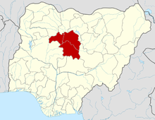 | |
This article is issued from Wikipedia - version of the 9/9/2016. The text is available under the Creative Commons Attribution/Share Alike but additional terms may apply for the media files.