Kandal Stueng District
| Kandal Steung កណ្តាលស្ទឹង | |
|---|---|
| District (srok) | |
 Kandal Steung | |
| Coordinates: 11°24′24″N 104°50′8″E / 11.40667°N 104.83556°E | |
| Country |
|
| Province | Kandal Province |
| Communes | 23 |
| Villages | 154 |
| Population (1998)[1] | |
| • Total | 76,549 |
| Time zone | +7 |
| Geocode | 0801 |
Kandal Stueng District (Khmer: ស្រុកកណ្តាលស្ទឹង) is a district (srok) of Kandal Province, Cambodia. The district is subdivided into 23 communes (khum) and 154 villages (phum).[2]
References
- ↑ General Population Census of Cambodia, 1998: Village Gazetteer. National Institute of Statistics. February 2000. pp. 149–152.
- ↑ "Kandal Administration". Royal Government of Cambodia. Retrieved 2009-01-27.
External links
| Capital city | 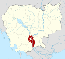 | |
|---|---|---|
| Districts | ||
Coordinates: 11°24′24″N 104°50′8″E / 11.40667°N 104.83556°E
This article is issued from Wikipedia - version of the 10/11/2016. The text is available under the Creative Commons Attribution/Share Alike but additional terms may apply for the media files.