Kasel-Golzig
Kasel-Golzig is a municipality in the district of Dahme-Spreewald in Brandenburg in Germany.
Demography
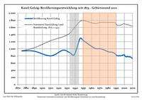
Development of population since 1875 within the current boundaries (Blue line: Population; Dotted line: Comparison to population development of Brandenburg state; Grey background: Time of Nazi rule; Red background: Time of communist rule)
Kasel-Golzig:
Population development within the current boundaries[2]
| Year |
Population |
|
|
|---|
| 1875 | 943 |
| 1890 | 934 |
| 1910 | 803 |
| 1925 | 961 |
| 1933 | 897 |
| 1939 | 840 |
| 1946 | 1 290 |
| 1950 | 1 232 |
| 1964 | 1 016 |
| 1971 | 1 003 |
|
|
| Year |
Population |
|
|
|---|
| 1981 | 915 |
| 1985 | 906 |
| 1989 | 859 |
| 1990 | 828 |
| 1991 | 808 |
| 1992 | 809 |
| 1993 | 800 |
| 1994 | 811 |
| 1995 | 803 |
| 1996 | 808 |
|
|
| Year |
Population |
|
|
|---|
| 1997 | 809 |
| 1998 | 826 |
| 1999 | 826 |
| 2000 | 834 |
| 2001 | 794 |
| 2002 | 780 |
| 2003 | 776 |
| 2004 | 791 |
| 2005 | 779 |
| 2006 | 772 |
|
|
| Year |
Population |
|
|
|---|
| 2007 | 779 |
| 2008 | 764 |
| 2009 | 746 |
| 2010 | 733 |
| 2011 | 748 |
| 2012 | 745 |
| 2013 | 685 |
|
|
References
- ↑ "Bevölkerung im Land Brandenburg nach amtsfreien Gemeinden, Ämtern und Gemeinden 31. Dezember 2015 (Fortgeschriebene amtliche Einwohnerzahlen auf Grundlage des Zensus 2011)". Amt für Statistik Berlin-Brandenburg (in German). 2016.
- ↑ Detailed data sources are to be found in the Wikimedia Commons.Population Projection Brandenburg at Wikimedia Commons

