Straupitz
Straupitz (Lower Sorbian: Tšupc) is a municipality in the district of Dahme-Spreewald in Brandenburg in Germany.
Demography
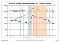
Development of population since 1875 within the current boundaries (Blue line: Population; Dotted line: Comparison to population development of Brandenburg state; Grey background: Time of Nazi rule; Red background: Time of communist rule)
Straupitz:
Population development within the current boundaries (2013)[2]
| Year |
Population |
|---|
| 1875 | 1 190 |
| 1890 | 1 278 |
| 1910 | 1 147 |
| 1925 | 1 106 |
| 1933 | 1 044 |
| 1939 | 963 |
| 1946 | 1 638 |
| 1950 | 1 648 |
| 1964 | 1 454 |
| 1971 | 1 502 |
|
|
| Year |
Population |
|---|
| 1981 | 1 372 |
| 1985 | 1 327 |
| 1989 | 1 344 |
| 1990 | 1 333 |
| 1991 | 1 311 |
| 1992 | 1 312 |
| 1993 | 1 299 |
| 1994 | 1 295 |
| 1995 | 1 293 |
| 1996 | 1 276 |
|
|
| Year |
Population |
|---|
| 1997 | 1 236 |
| 1998 | 1 217 |
| 1999 | 1 203 |
| 2000 | 1 184 |
| 2001 | 1 163 |
| 2002 | 1 132 |
| 2003 | 1 115 |
| 2004 | 1 090 |
| 2005 | 1 054 |
| 2006 | 1 042 |
|
|
| Year |
Population |
|---|
| 2007 | 1 031 |
| 2008 | 999 |
| 2009 | 997 |
| 2010 | 988 |
| 2011 | 1 015 |
| 2012 | 993 |
| 2013 | 991 |
|
|
References

