Kaymaz
| Kaymaz | |
|---|---|
| Town | |
|
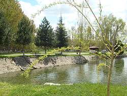
A scene from the town | |
 Kaymaz Location in Turkey | |
| Coordinates: 39°31′N 31°11′E / 39.517°N 31.183°ECoordinates: 39°31′N 31°11′E / 39.517°N 31.183°E | |
| Country |
|
| Province | Eskişehir Province |
| District | Sivrihisar |
| Elevation | 970 m (3,180 ft) |
| Population (2012) | |
| • Total | 1,254 |
| Time zone | EET (UTC+2) |
| • Summer (DST) | EEST (UTC+3) |
| Postal code | 26640 |
| Area code(s) | 0222 |
| Licence plate | 26 |
Kaymaz is a town in the Sivrihisar district of Eskişehir Province, Turkey. It is situated at 39°31′N 31°11′E / 39.517°N 31.183°E, on Turkish state highway ![]() which connects Eskişehir to Ankara. It is 65 kilometres (40 mi) south east of Eskişehir and 36 kilometres (22 mi) west of Sivrihisar. The population of Kaymaz was 1254[1] as of 2012. The town is an historical settlement and it was named as Troknada during the Phyrgiaan kingdom. Later it was renamed as Kaytrus and eventually the name Kaymaz was adopted.
which connects Eskişehir to Ankara. It is 65 kilometres (40 mi) south east of Eskişehir and 36 kilometres (22 mi) west of Sivrihisar. The population of Kaymaz was 1254[1] as of 2012. The town is an historical settlement and it was named as Troknada during the Phyrgiaan kingdom. Later it was renamed as Kaytrus and eventually the name Kaymaz was adopted.
In 1963, it was declared a seat of township. There are various ruins around the town. In contrast to general scenery of Central Anatolia, Kaymaz is a watery town thanks to Kaymaz Dam to the north east of the town. It is also known as Yeşilkaymaz ("Green Kaymaz"). Beans and cherries are the main products of the town.[2]
It has an annual Festival of Kuru Fasulye.[3]
See also
References
- ↑ Statistical Institute
- ↑ Town page (Turkish)
- ↑ http://www.sabah.com.tr/eskisehir-bolge/2013/06/17/kaymaz-beldesi-kuru-fasulye-festivali