Koos

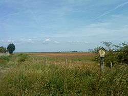
Koos is the largest of several small islands in the Bay of Greifswald, Mecklenburg-Vorpommern, Germany. It has an area of 772 hectares and a maximum elevation of just above three meters.[1] The island is a largely uninhabited natural reserve with restricted access.[2][3] It is separated from the mainland by Kooser Bucht and Kooser See, two bays connected by a tiny strait, Beek.[1]
In 1241, Barnuta, prince of Rügen, granted Koos (then "Chosten") to Eldena abbey (then "Hilda"),[4] later it became a possession of the Hanseatic town of Greifswald, located a few kilometers southward. A medieval burgh has been suggested on the isle, but not verified.[5] A 17th-century Dutch settlement had disappeared in the 18th century. Koos is administered by the nearby town of Greifswald.[3]
References
- 1 2 Map of Koos, elevation and settlements detailed
- ↑ Declaration of Koos as part of a Naturschutzgebiet "Insel Koos, Kooser See und Wampener Riff"
- 1 2 The island is off limits to the general public; driving to the island with a motor vehicle is only permitted to authorised individuals. Detailed list of protected areas within the Greifswald city limits
- ↑ Christian Lübke, Struktur und Wandel im Früh- und Hochmittelalter: eine Bestandsaufnahme aktueller Forschungen zur Germania Slavica, Franz Steiner Verlag, 1998, p. 308, ISBN 3-515-07114-8
- ↑ Christian Lübke, Struktur und Wandel im Früh- und Hochmittelalter: eine Bestandsaufnahme aktueller Forschungen zur Germania Slavica, Franz Steiner Verlag, 1998, p.305, ISBN 3-515-07114-8
External links
Coordinates: 54°10′N 13°25′E / 54.167°N 13.417°E
|  | |