Kunčice pod Ondřejníkem
| Kunčice pod Ondřejníkem | |||
|---|---|---|---|
| Municipality and village | |||
 | |||
| |||
 Kunčice pod Ondřejníkem Location in the Czech Republic | |||
| Coordinates: 49°32′28″N 18°16′52″E / 49.54111°N 18.28111°ECoordinates: 49°32′28″N 18°16′52″E / 49.54111°N 18.28111°E | |||
| Country |
| ||
| Region | Moravian-Silesian Region | ||
| District | Frýdek-Místek District | ||
| Time zone | CET (UTC+1) | ||
| • Summer (DST) | CEST (UTC+2) | ||
| Website |
www | ||

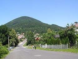
Kunčice pod Ondřejníkem is a village in Frýdek-Místek District, Moravian-Silesian Region, Czech Republic. It had an estimated population of 2,004 in 2006. There is an 18th-century wooden church in the village. It was relocated here in 1931 from the Subcarpathian Rus. Kunčice pod Ondřejníkem lies in the Moravian-Silesian Beskids and is a popular spot for tourists.
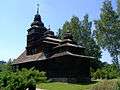 Church of Saints Procopius and Barbara
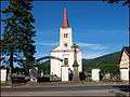 Church of Saint Mary Magdalene
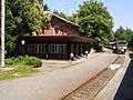 Train station
External links
| Wikimedia Commons has media related to Kunčice pod Ondřejníkem. |
- (Czech) Official website
- (Czech) Mikroregion Frýdlantsko
- (Czech) Paper model of St. Prokop and Barbora church in Kuncice pod Ondrejnik
This article is issued from Wikipedia - version of the 4/7/2016. The text is available under the Creative Commons Attribution/Share Alike but additional terms may apply for the media files.