La Couronne, Charente
| La Couronne | ||
|---|---|---|
|
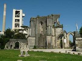
Ruins of the abbey | ||
| ||
 La Couronne | ||
|
Location within Nouvelle-Aquitaine region  La Couronne | ||
| Coordinates: 45°36′30″N 0°06′03″E / 45.6083°N 0.1008°ECoordinates: 45°36′30″N 0°06′03″E / 45.6083°N 0.1008°E | ||
| Country | France | |
| Region | Nouvelle-Aquitaine | |
| Department | Charente | |
| Arrondissement | Angoulême | |
| Canton | La Couronne | |
| Intercommunality | Grand Angoulême | |
| Government | ||
| • Mayor (2008–2014) | Jean-François Dauré | |
| Area1 | 28.82 km2 (11.13 sq mi) | |
| Population (2008)2 | 7,013 | |
| • Density | 240/km2 (630/sq mi) | |
| Time zone | CET (UTC+1) | |
| • Summer (DST) | CEST (UTC+2) | |
| INSEE/Postal code | 16113 / 16400 | |
| Elevation |
31–137 m (102–449 ft) (avg. 100 m or 330 ft) | |
|
1 French Land Register data, which excludes lakes, ponds, glaciers > 1 km² (0.386 sq mi or 247 acres) and river estuaries. 2 Population without double counting: residents of multiple communes (e.g., students and military personnel) only counted once. | ||
.svg.png)
La Couronne is a commune in the Charente department in southwestern France.
Population
| Historical population | ||
|---|---|---|
| Year | Pop. | ±% |
| 1793 | 2,050 | — |
| 1800 | 1,407 | −31.4% |
| 1806 | 1,264 | −10.2% |
| 1821 | 1,801 | +42.5% |
| 1831 | 2,007 | +11.4% |
| 1841 | 2,355 | +17.3% |
| 1846 | 2,311 | −1.9% |
| 1851 | 2,340 | +1.3% |
| 1856 | 2,550 | +9.0% |
| 1861 | 2,700 | +5.9% |
| 1866 | 2,882 | +6.7% |
| 1872 | 2,617 | −9.2% |
| 1876 | 2,876 | +9.9% |
| 1881 | 3,301 | +14.8% |
| 1886 | 3,271 | −0.9% |
| 1891 | 3,490 | +6.7% |
| 1896 | 3,457 | −0.9% |
| 1901 | 3,700 | +7.0% |
| 1906 | 3,847 | +4.0% |
| 1911 | 3,852 | +0.1% |
| 1921 | 3,763 | −2.3% |
| 1926 | 3,897 | +3.6% |
| 1931 | 4,271 | +9.6% |
| 1936 | 4,411 | +3.3% |
| 1946 | 4,735 | +7.3% |
| 1954 | 5,123 | +8.2% |
| 1962 | 5,257 | +2.6% |
| 1968 | 5,394 | +2.6% |
| 1975 | 5,901 | +9.4% |
| 1982 | 6,076 | +3.0% |
| 1990 | 6,295 | +3.6% |
| 1999 | 6,857 | +8.9% |
| 2008 | 7,013 | +2.3% |
See also
References
| Wikimedia Commons has media related to La Couronne (Charente). |
This article is issued from Wikipedia - version of the 2/12/2016. The text is available under the Creative Commons Attribution/Share Alike but additional terms may apply for the media files.