Lake Dick, Arkansas
| Lake Dick, Arkansas | |
|---|---|
| Unincorporated community | |
 | |
 Lake Dick, Arkansas  Lake Dick, Arkansas | |
| Coordinates: 34°15′07″N 91°50′19″W / 34.25194°N 91.83861°WCoordinates: 34°15′07″N 91°50′19″W / 34.25194°N 91.83861°W | |
| Country | United States |
| State | Arkansas |
| County | Jefferson |
| Elevation | 210 ft (60 m) |
| Time zone | Central (CST) (UTC-6) |
| • Summer (DST) | CDT (UTC-5) |
| Area code(s) | 870 |
| GNIS feature ID | 77430[1] |
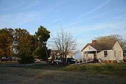
Lake Dick is an unincorporated community in Jefferson County, Arkansas, United States. Lake Dick is northeast of Pine Bluff and south of Altheimer.
The Resettlement Administration, a New Deal program which supported farming projects, established the community on the shore of Lake Dick in 1936. The administration built the community's buildings in the next two years and relocated 80 farming families from throughout Arkansas to the community. Unlike most Resettlement Administration farming communities, which divided farmland among their residents, Lake Dick was a cooperative farming project; families jointly participated in producing crops on community farmland according to a work schedule. Roughly one-third of the community's original buildings are still in place; most of the others, particularly the houses, have been relocated to other nearby settlements.[2]
The community was added to the National Register of Historic Places in 1975.[3]
See also
References
- ↑ "US Board on Geographic Names". United States Geological Survey. 2007-10-25. Retrieved 2008-01-31.
- ↑ Kirk, Dianna (September 10, 1974). "National Register of Historic Places Inventory - Nomination Form: Lake Dick" (PDF). National Park Service. Retrieved June 4, 2014.
- ↑ National Park Service (2010-07-09). "National Register Information System". National Register of Historic Places. National Park Service.
Municipalities and communities of Jefferson County, Arkansas, United States | ||
|---|---|---|
| Cities | 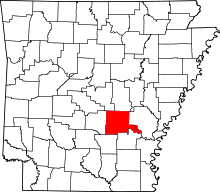 | |
| Towns | ||
| CDP | ||
| Unincorporated communities | ||
| Footnotes | ‡This populated place also has portions in an adjacent county or counties | |