Lake Lure, North Carolina
| Lake Lure, North Carolina | |
|---|---|
| Town | |
 Location of Lake Lure, North Carolina. | |
| Coordinates: 35°26′41″N 82°11′28″W / 35.44472°N 82.19111°WCoordinates: 35°26′41″N 82°11′28″W / 35.44472°N 82.19111°W | |
| Country | United States |
| State | North Carolina |
| County | Rutherford |
| Area | |
| • Total | 14.8 sq mi (38.3 km2) |
| • Land | 13.6 sq mi (35.2 km2) |
| • Water | 1.2 sq mi (3.1 km2) |
| Elevation | 1,125 ft (343 m) |
| Population (2010) | |
| • Total | 1,192 |
| • Density | 75.6/sq mi (29.2/km2) |
| Time zone | Eastern (EST) (UTC-5) |
| • Summer (DST) | EDT (UTC-4) |
| ZIP code | 28746 |
| Area code(s) | 828 |
| FIPS code | 37-36500[1] |
| GNIS feature ID | 1021079[2] |
| Website | www.townoflakelure.com |
Lake Lure is a town in Rutherford County, North Carolina, United States. In 2010 the town population was 1,192. Lake Lure was incorporated in 1927, and acquired the lake after which it is named in 1965.
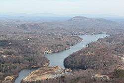
| Lake Lure | |
|---|---|
 | |
| Location | Rutherford County, North Carolina |
| Coordinates | 35°25′55″N 82°11′50″W / 35.43194°N 82.19722°W |
| Lake type | reservoir |
| Primary inflows | Rocky Broad River |
| Primary outflows | Rocky Broad River |
| Basin countries | United States |
| Surface area | 717 acres (2.9 km2) |
| Surface elevation | 911 ft (278 m) |
History
In 1902, Dr. Lucius B. Morse and his brothers Hiram and Asahel purchased 64 acres (0.26 km2) around Chimney Rock (within present-day Chimney Rock State Park) for $5,000. They later acquired enough land in the area to bring the total to 8,000 acres (32 km2). Lucius Morse's wife Elizabeth is credited with naming the lake (and the town).[3]
In 1925, the Morse family created Carolina Mountain Power Company and funded the construction of a dam on the Broad River (through a mortgage) which produced the lake after which the town is named. The full impoundment of Lake Lure was completed in 1927. At ordinary water levels, Lake Lure covers approximately 720 acres (2.9 km2) and has a shoreline of approximately 27 miles (43 km). The dam's power plant began operations in 1928 with the sale of electricity under a 10-year contract to Blue Ridge Power Co., a local predecessor of Duke Power.
In 1929, the plans for development came to a halt with the advent of the Great Depression. A mortgage-holder, Stroud & Company of Philadelphia, foreclosed on the lake and the dam. Stroud owned them and the power the dam generated until 1965. In 1963, the North Carolina General Assembly enacted the legislation that authorized the Town of Lake Lure to issue revenue bonds for the purpose of acquiring the assets from Stroud. The dam, power company, and real estate of Lake Lure were acquired by the Town of Lake Lure in 1965.[3]
In modern times, the town continues to sell electricity to Duke Energy, although profits from the dam now come second to maintaining a fixed water level year-round. Recreation and tourism have become crucial to the town's economy.
IN 1999, Pine Gables was added to the National Register of Historic Places.[4]
Demographics
| Historical population | |||
|---|---|---|---|
| Census | Pop. | %± | |
| 1930 | 204 | — | |
| 1940 | 212 | 3.9% | |
| 1950 | 174 | −17.9% | |
| 1960 | 233 | 33.9% | |
| 1970 | 456 | 95.7% | |
| 1980 | 488 | 7.0% | |
| 1990 | 691 | 41.6% | |
| 2000 | 1,027 | 48.6% | |
| 2010 | 1,192 | 16.1% | |
| Est. 2015 | 1,184 | [5] | −0.7% |
As of the census[1] of 2000, there were 1,027 people, 495 households, and 359 families residing in the town. The population density was 75.6 people per square mile (29.2/km2). There were 1,957 housing units at an average density of 144.1 per square mile (55.6/km2). The racial makeup of the town was 97.27% White, 1.46% African American, 0.29% Asian, 0.19% Native American, and 0.78% from two or more races. Hispanic or Latino of any race were 0.10% of the population.
There were 495 households out of which 10.1% had children under the age of 18 living with them, 68.1% were married couples living together, 3.2% had a female householder with no husband present, and 27.3% were non-families. 22.4% of all households were made up of individuals and 12.5% had someone living alone who was 65 years of age or older. The average household size was 2.07 and the average family size was 2.38.
In the town the population was spread out with 10.4% under the age of 18, 3.2% from 18 to 24, 14.1% from 25 to 44, 35.9% from 45 to 64, and 36.3% who were 65 years of age or older. The median age was 59 years. For every 100 females there were 103.0 males. For every 100 females age 18 and over, there were 102.6 males.
The median income for a household in the town was $38,417, and the median income for a family was $45,833. Males had a median income of $39,464 versus $23,333 for females. The per capita income for the town was $23,459. About 4.9% of families and 10.2% of the population were below the poverty line, including 11.7% of those under age 18 and 4.9% of those age 65 or over.
Geography
Lake Lure is located at 35°26′41″N 82°11′28″W / 35.444668°N 82.191243°W.[7] According to the United States Census Bureau, the town has a total area of 14.8 square miles (38 km2), of which, 13.6 square miles (35 km2) of it is land and 1.2 square miles (3.1 km2) of it (8.11%) is water.

Notable people
- Verda Welcome, Maryland educator and politician, was born in Lake Lure.
Filming location
The Lake Lure area has been used several times as a filming location, beginning with Thunder Road (1968). Other movies that include scenes filmed in or near Lake Lure are: A Breed Apart (1984), Firestarter (1984), Dirty Dancing (1987), and My Fellow Americans (1996). Scenes in the film The Last of the Mohicans (1992), including the final 17 minutes, were filmed at nearby Chimney Rock and Hickory Nut Gorge.[8] Also, the new film Careful What You Wish For starring Nick Jonas was filmed here.
References
- 1 2 "American FactFinder". United States Census Bureau. Retrieved 2008-01-31.
- ↑ "US Board on Geographic Names". United States Geological Survey. 2007-10-25. Retrieved 2008-01-31.
- 1 2 History of Lake Lure
- ↑ National Park Service (2010-07-09). "National Register Information System". National Register of Historic Places. National Park Service.
- ↑ "Annual Estimates of the Resident Population for Incorporated Places: April 1, 2010 to July 1, 2015". Retrieved July 2, 2016.
- ↑ "Census of Population and Housing". Census.gov. Retrieved June 4, 2015.
- ↑ "US Gazetteer files: 2010, 2000, and 1990". United States Census Bureau. 2011-02-12. Retrieved 2011-04-23.
- ↑ Popowski, Matt (2013). "The Last of the Mohicans returns to Chimney Rock June 15" (PDF) (Press release). Chimney Rock at Chimney Rock State Park. Retrieved June 5, 2013.
- Titles with locations including Lake Lure, North Carolina, USA. IMDB. Accessed January 12, 2007.
External links
- TownOfLakeLure.com, official website
- U.S. Geological Survey Geographic Names Information System: Lake Lure (populated place)
- U.S. Geological Survey Geographic Names Information System: Lake Lure (reservoir)
Municipalities and communities of Rutherford County, North Carolina, United States | ||
|---|---|---|
| Towns | 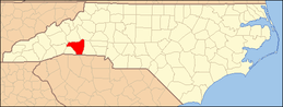 | |
| Village | ||
| CDPs | ||
| Unincorporated communities |
| |