Landrienne, Quebec
| Landrienne | |
|---|---|
| Township municipality | |
 | |
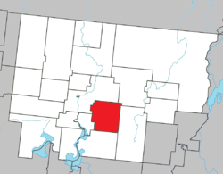 Location within Abitibi RCM. | |
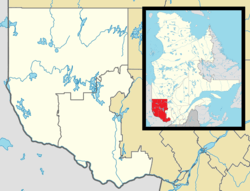 Landrienne Location in western Quebec. | |
| Coordinates: 48°33′N 77°57′W / 48.550°N 77.950°WCoordinates: 48°33′N 77°57′W / 48.550°N 77.950°W[1] | |
| Country |
|
| Province |
|
| Region | Abitibi-Témiscamingue |
| RCM | Abitibi |
| Settled | 1910s |
| Constituted | July 15, 1918 |
| Government[2] | |
| • Mayor | François Lemieux |
| • Federal riding | Abitibi—Témiscamingue |
| • Prov. riding | Abitibi-Ouest |
| Area[2][3] | |
| • Total | 274.90 km2 (106.14 sq mi) |
| • Land | 276.83 km2 (106.88 sq mi) |
|
There is an apparent contradiction between two authoritative sources | |
| Population (2011)[3] | |
| • Total | 977 |
| • Density | 3.5/km2 (9/sq mi) |
| • Pop 2006-2011 |
|
| • Dwellings | 397 |
| Time zone | EST (UTC−5) |
| • Summer (DST) | EDT (UTC−4) |
| Postal code(s) | J0Y 1V0 |
| Area code(s) | 819 |
| Highways |
|
| Website |
www |
Landrienne is a township municipality in the Canadian province of Quebec, located in the Abitibi Regional County Municipality. It is part of the census agglomeration of Amos.
Originally known as Saint-Barnabé-de-Landrienne, the place was named in honor of Jean-Marie Landriève Des Bordes (1712–1778), a French naval officer and Administrative Inspector.[1]
Demographics
The township had a population of 977 as of the Canada 2011 Census, and a land area of 276.83 square kilometres. Private dwellings occupied by usual residents are 379, out of 390 total dwellings. Mother tongues are:[4]
- English as first language: 0%
- French as first language: 100%
- English and French as first language: 0%
- Other as first language: 0%
Population trend:[5]
- Population in 2011: 977 (2006 to 2011 population change: -0.9%)
- Population in 2006: 986
- Population in 2001: 1072
- Population in 1996: 1007
- Population in 1991: 1044
Municipal council
- Mayor: François Lemieux
- Councillors: Julie Auger, Maryse Bélanger, Réal Champagne, Steve Champagne, Richard Lecompte, Carole Perron
References
- 1 2 Reference number 33933 of the Commission de toponymie du Québec (French)
- 1 2 "Landrienne". Répertoire des municipalités (in French). Ministère des Affaires municipales, des Régions et de l'Occupation du territoire. Retrieved 2011-01-11.
- 1 2 "Landrienne census profile". 2011 Census data. Statistics Canada. Retrieved 2011-01-11.
- ↑ "Landrienne community profile". 2006 Census data. Statistics Canada. Retrieved 2011-01-11.
- ↑ Statistics Canada: 1996, 2001, 2006, 2011 census
 |
Amos | La Morandière | | |
| Saint-Marc-de-Figuery | |
Barraute | ||
| ||||
| | ||||
| La Corne |
| Towns | |
|---|---|
| Municipalities | |
| Townships | |
| Parishes | |
| Unorganized territories | |
| |
This article is issued from Wikipedia - version of the 7/29/2016. The text is available under the Creative Commons Attribution/Share Alike but additional terms may apply for the media files.