Laredo, Missouri
| Laredo, Missouri | |
|---|---|
| City | |
|
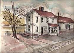
The former Milwaukee Railroad depot in Laredo. Watercolor by R.L. Huffstutter. | |
 Location of Laredo, Missouri | |
| Coordinates: 40°1′35″N 93°26′51″W / 40.02639°N 93.44750°WCoordinates: 40°1′35″N 93°26′51″W / 40.02639°N 93.44750°W | |
| Country | United States |
| State | Missouri |
| County | Grundy |
| Area[1] | |
| • Total | 0.28 sq mi (0.73 km2) |
| • Land | 0.28 sq mi (0.73 km2) |
| • Water | 0 sq mi (0 km2) |
| Elevation | 801 ft (244 m) |
| Population (2010)[2] | |
| • Total | 198 |
| • Estimate (2012[3]) | 200 |
| • Density | 707.1/sq mi (273.0/km2) |
| Time zone | Central (CST) (UTC-6) |
| • Summer (DST) | CDT (UTC-5) |
| ZIP code | 64652 |
| Area code(s) | 660 |
| FIPS code | 29-40736[4] |
| GNIS feature ID | 0720816[5] |
Laredo is a city in Grundy County, Missouri, United States. The population was 198 at the 2010 census. Laredo is pronounced "la-read-oh" which varies from the traditional pronunciation.
History
Laredo was founded in 1887.[6] The city was named after Laredo, Texas.[7] A post office called Laredo has been in operation since 1887.[8]
Geography
Laredo is located at 40°1′35″N 93°26′51″W / 40.02639°N 93.44750°W (40.026341, -93.447527).[9]
According to the United States Census Bureau, the city has a total area of 0.28 square miles (0.73 km2), all land.[1]
Demographics
| Historical population | |||
|---|---|---|---|
| Census | Pop. | %± | |
| 1900 | 286 | — | |
| 1910 | 758 | 165.0% | |
| 1920 | 728 | −4.0% | |
| 1930 | 578 | −20.6% | |
| 1940 | 1,421 | 145.8% | |
| 1950 | 426 | −70.0% | |
| 1960 | 370 | −13.1% | |
| 1970 | 383 | 3.5% | |
| 1980 | 340 | −11.2% | |
| 1990 | 205 | −39.7% | |
| 2000 | 250 | 22.0% | |
| 2010 | 198 | −20.8% | |
| Est. 2015 | 196 | [10] | −1.0% |
2010 census
As of the census[2] of 2010, there were 198 people, 89 households, and 59 families residing in the city. The population density was 707.1 inhabitants per square mile (273.0/km2). There were 128 housing units at an average density of 457.1 per square mile (176.5/km2). The racial makeup of the city was 99.5% White and 0.5% from two or more races.
There were 89 households of which 24.7% had children under the age of 18 living with them, 53.9% were married couples living together, 9.0% had a female householder with no husband present, 3.4% had a male householder with no wife present, and 33.7% were non-families. 28.1% of all households were made up of individuals and 9% had someone living alone who was 65 years of age or older. The average household size was 2.22 and the average family size was 2.68.
The median age in the city was 47.5 years. 16.2% of residents were under the age of 18; 10.2% were between the ages of 18 and 24; 17.7% were from 25 to 44; 32.9% were from 45 to 64; and 23.2% were 65 years of age or older. The gender makeup of the city was 49.0% male and 51.0% female.
2000 census
As of the census[4] of 2000, there were 250 people, 113 households, and 69 families residing in the city. The population density was 913.8 people per square mile (357.5/km²). There were 138 housing units at an average density of 504.4 per square mile (197.3/km²). The racial makeup of the city was 97.20% White, and 2.80% from two or more races. Hispanic or Latino of any race were 0.80% of the population.
There were 113 households out of which 23.0% had children under the age of 18 living with them, 49.6% were married couples living together, 8.0% had a female householder with no husband present, and 38.9% were non-families. 37.2% of all households were made up of individuals and 23.9% had someone living alone who was 65 years of age or older. The average household size was 2.21 and the average family size was 2.88.
In the city the population was spread out with 25.6% under the age of 18, 5.6% from 18 to 24, 24.4% from 25 to 44, 24.4% from 45 to 64, and 20.0% who were 65 years of age or older. The median age was 41 years. For every 100 females there were 98.4 males. For every 100 females age 18 and over, there were 91.8 males.
The median income for a household in the city was $20,536, and the median income for a family was $29,688. Males had a median income of $23,828 versus $16,250 for females. The per capita income for the city was $12,451. About 13.4% of families and 19.6% of the population were below the poverty line, including 42.2% of those under the age of eighteen and 9.5% of those sixty five or over.
References
- 1 2 "US Gazetteer files 2010". United States Census Bureau. Retrieved 2012-07-08.
- 1 2 "American FactFinder". United States Census Bureau. Retrieved 2012-07-08.
- ↑ "Population Estimates". United States Census Bureau. Retrieved 2013-05-30.
- 1 2 "American FactFinder". United States Census Bureau. Retrieved 2008-01-31.
- ↑ "US Board on Geographic Names". United States Geological Survey. 2007-10-25. Retrieved 2008-01-31.
- ↑ "Grundy County Place Names, 1928–1945 (archived)". The State Historical Society of Missouri. Retrieved 3 October 2016.
- ↑ Ramsay, Robert L. (1952). Our Storehouse of Missouri Place Names. University of Missouri Press. p. 26.
- ↑ "Post Offices". Jim Forte Postal History. Retrieved 3 October 2016.
- ↑ "US Gazetteer files: 2010, 2000, and 1990". United States Census Bureau. 2011-02-12. Retrieved 2011-04-23.
- ↑ "Annual Estimates of the Resident Population for Incorporated Places: April 1, 2010 to July 1, 2015". Retrieved July 2, 2016.
- ↑ "Census of Population and Housing". Census.gov. Retrieved June 4, 2015.
External links
- Historic maps of Laredo in the Sanborn Maps of Missouri Collection at the University of Missouri
Municipalities and communities of Grundy County, Missouri, United States | ||
|---|---|---|
| Cities |  | |
| Village | ||
| Townships | ||
| CDPs |
| |
| Unincorparated communities | ||
| Footnotes | ‡This populated place also has portions in an adjacent county or counties | |